All Activity
- Past hour
-
Mild Christmas Day on euro. Just like the ones we used to know.
-

December 2025 regional war/obs/disco thread
weatherwiz replied to Torch Tiger's topic in New England
Who the heck knows what to expect after Christmas. The signals are all over the place, especially with the structure and orientation of the pattern which will play a critical roll. If I had to be nervous about something post Christmas it would be shortwave moving into the West getting obliterated as they move across the Inter-mountain West...but there is really no sense of worrying about this nor any point to feeling confident or not confident. -

Central PA Winter 25/26 Discussion and Obs
TimB replied to MAG5035's topic in Upstate New York/Pennsylvania
Now do the 12z euro. -

Central PA Winter 25/26 Discussion and Obs
Mount Joy Snowman replied to MAG5035's topic in Upstate New York/Pennsylvania
Thought this was a curious post by MU. Is he implying that one day in the low 50s qualifies as a “torch period”? I know he loves his warm weather but it seemed weirdly defensive to me and wasn’t sure who he was addressing.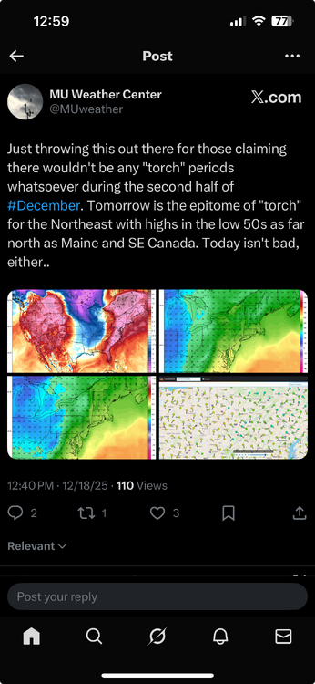
-

December 2025 regional war/obs/disco thread
Damage In Tolland replied to Torch Tiger's topic in New England
Been TTTE. They keep screaming wearing boxers outside on Boxing Day -

December 2025 regional war/obs/disco thread
weathafella replied to Torch Tiger's topic in New England
Also, some of the torchy guidance has a Canadian high in a nice position. The warmth seems at least partially suspect. We’ll see. -
1977 did it about 30 or so
-

-
I drove through fog like that once after a big snow in Jan. 2008. Temps shot into the 50’s with a foot of snow on the ground. Visibility had to be 25 feet on State Road 2 and I wasn’t sure if I should maintain the speed limit and risk plowing into a stopped vehicle or slow down and risk getting hit from behind. It only lasted about five miles but that was scary af
-
Impressive squall line by December standards in Illinois rn
-

December 2025 regional war/obs/disco thread
WxWatcher007 replied to Torch Tiger's topic in New England
Yeah I liked that signal a few days ago and I think we’re in good shape right now. We definitely need to bring that home. A few inches would put us closer to Dec climo with uncertainty about the post Christmas possibilities. -
Yeah agree. Luckily it’s cold to start out, but shift that south a bit.
-
Euro is still pretty nice for 12/23. Would be awesome to get that to trend a smidge further south to juice it up a little more.
-
December 2025 regional war/obs/disco thread
Damage In Tolland replied to Torch Tiger's topic in New England
You sure were. You’re welcome -
Clearly the goal posts are still very wide, and until the block establishes itself there will be a lot of uncertainty in our sensible weather outcomes. 6z takes us to the promised land while 12z shows us a poor case scenario. What’s most likely to happen is something in the middle, cool dreary CAD with maybe a mixed event with more snow to the north of this sub (and even this is low confidence).
-
Someone is nervously melting
-
December 2025 regional war/obs/disco thread
Damage In Tolland replied to Torch Tiger's topic in New England
You should see the melts in a text group with 3 well known Mets.after they saw the gfs. I had to talk sense into them . Imagine that -
Teetering in Tolland
-
Yep this is a good soaking rain that we needed ahead of the pattern change
-
Anything post-Xmas needs to be taken a massive grain of salt right now around this part of the country. The only certainty is the middle of the country will blowtorch.
-
URGENT - WEATHER MESSAGE National Weather Service Baltimore MD/Washington DC 1153 AM EST Thu Dec 18 2025 DCZ001-MDZ013-014-503-504-VAZ026-027-029>031-036>040-053-054-501-505- 506-526-190100- /O.EXA.KLWX.WI.Y.0024.251219T1700Z-251220T0000Z/ District of Columbia-Prince Georges-Anne Arundel-Northwest Montgomery-Central and Southeast Montgomery-Rockingham-Shenandoah- Page-Warren-Clarke-Nelson-Albemarle-Greene-Madison-Rappahannock- Fairfax-Arlington/Falls Church/Alexandria-Northern Fauquier- Western Loudoun-Eastern Loudoun-Northwest Prince William- 1153 AM EST Thu Dec 18 2025 ...WIND ADVISORY IN EFFECT FROM NOON TO 7 PM EST FRIDAY... * WHAT...West winds 20 to 30 mph with gusts of 45 to 55 mph expected. * WHERE...Washington DC, and portions of central Maryland, and central, northern, northwest, and western Virginia. * WHEN...From noon to 7 PM EST Friday. * IMPACTS...Gusty winds will blow around unsecured objects. Tree limbs could be blown down and a few power outages may result. * ADDITIONAL DETAILS...Gusty winds may persist for several more hours Friday evening.
-
URGENT - WEATHER MESSAGE National Weather Service Baltimore MD/Washington DC 1153 AM EST Thu Dec 18 2025 MDZ003>006-008-011-505>508-VAZ028-WVZ050>053-055-190100- /O.CON.KLWX.WI.Y.0024.251219T1700Z-251220T0000Z/ Washington-Frederick MD-Carroll-Northern Baltimore-Cecil-Southern Baltimore-Northwest Howard-Central and Southeast Howard-Northwest Harford-Southeast Harford-Frederick VA-Hampshire-Morgan-Berkeley- Jefferson-Hardy- 1153 AM EST Thu Dec 18 2025 ...WIND ADVISORY REMAINS IN EFFECT FROM NOON TO 7 PM EST FRIDAY... * WHAT...West winds 20 to 30 mph with gusts of 45 to 55 mph expected. * WHERE...Portions of central, north-central, northeast, and northern Maryland, northwest Virginia, and eastern West Virginia. * WHEN...From noon to 7 PM EST Friday. * IMPACTS...Gusty winds will blow around unsecured objects. Tree limbs could be blown down and a few power outages may result. * ADDITIONAL DETAILS...Gusty winds may persist for several more hours Friday evening. A few gusts to near 60 mph are possible, especially along and just east of higher terrain.
-
URGENT - WEATHER MESSAGE National Weather Service Baltimore MD/Washington DC 1153 AM EST Thu Dec 18 2025 MDZ502-509-VAZ503-504-507-508-WVZ502-504-506-190100- /O.UPG.KLWX.WI.Y.0024.251219T1100Z-251220T0000Z/ /O.NEW.KLWX.HW.W.0004.251219T1100Z-251220T0000Z/ Central and Eastern Allegany-Western Garrett-Western Highland- Eastern Highland-Northern Virginia Blue Ridge-Central Virginia Blue Ridge-Eastern Grant-Eastern Mineral-Eastern Pendleton- 1153 AM EST Thu Dec 18 2025 ...HIGH WIND WARNING IN EFFECT FROM 6 AM TO 7 PM EST FRIDAY... * WHAT...West winds 25 to 35 mph with gusts up to 60 mph expected. * WHERE...In Maryland, Central and Eastern Allegany and Western Garrett Counties. In Virginia, Central Virginia Blue Ridge and Northern Virginia Blue Ridge, and Eastern Highland and Western Highland Counties. In West Virginia, Eastern Grant, Eastern Mineral, and Eastern Pendleton Counties. * WHEN...From 6 AM to 7 PM EST Friday. * IMPACTS...Damaging winds will blow down trees and power lines. Widespread power outages are expected. Travel will be difficult, especially for high profile vehicles. * ADDITIONAL DETAILS...The strongest winds are expected above 3000 feet around or just before daybreak Friday. A second and more widespread surge will follow from about midday through late afternoon, with a third surge of wind possible Friday evening.
-
Some of the more impressive fog I have ever seen. Was in a turn lane and could not see the stop light until I was at the line, so well under 50 ft.
-
URGENT - WEATHER MESSAGE National Weather Service Baltimore MD/Washington DC 1153 AM EST Thu Dec 18 2025 MDZ501-510-WVZ501-503-505-190100- /O.UPG.KLWX.HW.A.0003.251219T1100Z-251220T0300Z/ /O.NEW.KLWX.HW.W.0004.251219T1100Z-251220T0300Z/ Extreme Western Allegany-Eastern Garrett-Western Grant-Western Mineral-Western Pendleton- 1153 AM EST Thu Dec 18 2025 ...HIGH WIND WARNING IN EFFECT FROM 6 AM TO 10 PM EST FRIDAY... * WHAT...West winds 25 to 40 mph with gusts up to 65 mph expected. * WHERE...In Maryland, Eastern Garrett and Extreme Western Allegany Counties. In West Virginia, Western Grant, Western Mineral, and Western Pendleton Counties. * WHEN...From 6 AM to 10 PM EST Friday. * IMPACTS...Damaging winds will blow down trees and power lines. Widespread power outages are expected. Travel will be difficult, especially for high profile vehicles. * ADDITIONAL DETAILS...The strongest winds are expected above 3000 feet around or just before daybreak Friday. A second and more widespread surge will follow from about midday through late afternoon, with a third surge of wind expected Friday evening.


