All Activity
- Past hour
-
2025. Most boring year ever.
-
Per the latest Euro Weeklies: After Humberto and Imelda wind down ~10/4-5, there looks to be a brief break overall. However, don’t get too comfortable as activity markedly picks up again to above normal on the run in the Gulf, NW Caribbean, and SW Atlantic (including Yucatan, Cuba, NC/NE US Gulf coast, FL/SE US coast, Bahamas, and Bermuda) with 140% of normal 10/13-19 and 160% of normal 10/20-26. This would be a 3rd peak of sorts for 2025 should it verify. This active period would resemble a somewhat toned down version of the freakishly active late seasons of 2020 and 2005 and similar to 1950, 1878, and 1870 for that area. 10/13-19: 10/20-26:


-

September 2025 OBS-Discussion centered NYC subforum
SACRUS replied to wdrag's topic in New York City Metro
71 / 65 clearig out after 0.19 in the bucker mostly overnight. Low - mid 80s today, Upper 70s / low 80s tomorrow and Tuesday - clouds could keep it lower Tue. Humberto and Imelda tango exit stage with most of the rain chances for the next week. 2 days of a cooler ENE/NE flow 10/2-10/3 - ridge anchoreed intot he northeast and its overall warm beyond there. 9/28 - 10/1: Warm - to much warmer than normal 10/2 - 10/3 : Cooler onshore ENE/NE flow 10/4 - beyond ; Warmer / much warmer than normal (more 80s 10/6-10/7) -
Going to be weird to have two consecutive morning Sunday games for my Vikes.
-

2025 Mid-Atlantic Garden, Lawn, and Other Green Stuff Thread
WxUSAF replied to mattie g's topic in Mid Atlantic
After what had been a pretty tame year for mosquitoes, this last week has brought them out with a vengeance -
(002).thumb.png.6e3d9d46bca5fe41aab7a74871dd8af8.png)
Central PA Fall Discussions and Obs
ChescoWx replied to ChescoWx's topic in Upstate New York/Pennsylvania
Today will be our warmest day of the week along with some relatively high humidity for late September. Today’s highs will be in the upper 70's in the higher spots to lower 80's in valley locations. A couple of degrees cooler tomorrow followed by our chilliest weather so far this autumn season with highs by mid-week remaining in the 60's and morning lows well down into the 40's with even some 30's possible for our colder valley locations. We look dry through the entire week.

-
E PA/NJ/DE Autumn 2025 Obs/Discussion
ChescoWx replied to PhiEaglesfan712's topic in Philadelphia Region
Today will be our warmest day of the week along with some relatively high humidity for late September. Today’s highs will be in the upper 70's in the higher spots to lower 80's in valley locations. A couple of degrees cooler tomorrow followed by our chilliest weather so far this autumn season with highs by mid-week remaining in the 60's and morning lows well down into the 40's with even some 30's possible for our colder valley locations. We look dry through the entire week.
-

September 2025 OBS-Discussion centered NYC subforum
Sundog replied to wdrag's topic in New York City Metro
You can't compare extremes that occur in winter to Fall. There's a reason there's no +10 month in summer for example. Going another +2.5 over the warmest October monthly average maximum is a big deal. October 1947 btw finished +5.7. -

2025-2026 ENSO
so_whats_happening replied to 40/70 Benchmark's topic in Weather Forecasting and Discussion
When they get going they have become really nice storms this year. Erin, Gabrielle, and Humberto all have had amazing satellite imagery. -
Sexy hurricane porn pics not enough to get it up.
-

September 2025 OBS-Discussion centered NYC subforum
anthonymm replied to wdrag's topic in New York City Metro
Uh .. this can happen nowadays. Look at Jan 2023, it was a +10 anomaly the whole month. Plus it's not even that unprecedented. 1947 had an average high of 72.5, which means we can easily beat that now. Also to get an average high temp of 75 you don't need mid 70s every day. -
The Euro has been just another model for a long time now. Even though this turn was part of the envelope of possibilities, what’s particularly jarring was the Euro/GFS and their ensembles choosing the wrong path together inside 100 hours. That’s noteworthy imo. The AI models seem to have schooled the legacy guidance on this one.
-
Central PA Fall Discussions and Obs
WxUSAF replied to ChescoWx's topic in Upstate New York/Pennsylvania
I guess they made it respectable at least? But chokers gonna choke -
September 2025 OBS-Discussion centered NYC subforum
Sundog replied to wdrag's topic in New York City Metro
Dude you need to chill, do you realize what you're typing? Mid 70s for the whole month of October? So a +10 monthly anomaly for highs huh? And you're basing this on what exactly? -
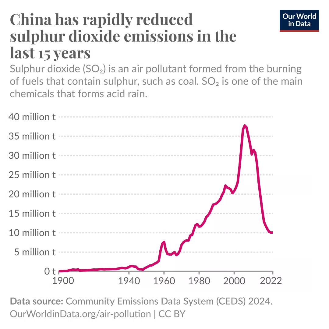
It’s good news for them that they have been removing sulfur dioxide at the coal plants and leading to cleaner air than they had just a decade ago. But this could also be a part of the puzzle as to why we have seen a sudden jump in global temperatures. The cleaner air could also mean less of an imperative for them to replace coal pants with renewables so we may see a long plateau but not a decline in coal burning. https://www.wired.com/story/in-an-odd-twist-cleaner-air-in-china-may-mean-a-warmer-earth/ OVER THE PAST 15 years, Chinese officials saved the lives of an estimated more than 200,000 residents by reducing the air pollution from coal-fired power plants. But this public health campaign has an unfortunate side effect: The drop in pollutants is helping warm the planet. https://ourworldindata.org/data-insights/china-has-reduced-sulphur-dioxide-emissions-by-more-than-two-thirds-in-the-last-15-years

-
lol you will be all over it- posting snow maps every model cycle.
-
4.1" for the month. Looks like that will be the total. Pretty good after a below normal August.
-
I maybe wrong but to my eye it looks like it's going be north and west of forecast from nhc based on the that solid line at bottom before next offical track update. No?

-
Thinking about making a Bloody Mary with breakfast, watching the game.
-
What a complete fold by the EURO models. Hail the new ICON/ Canadian Kings!!! In all seriousness, I will not fall for the EURO snow storm looks this winter when the other models show nothing....
-
September 2025 OBS-Discussion centered NYC subforum
anthonymm replied to wdrag's topic in New York City Metro
It's trivial for us to break high temp records now, as long as they're taken over a long enough period. -
Man what a flaccid season.
-

September 2025 OBS-Discussion centered NYC subforum
donsutherland1 replied to wdrag's topic in New York City Metro
Were that to happen, that would set a new record. The record is 72.5° in 1947. -
September 2025 OBS-Discussion centered NYC subforum
anthonymm replied to wdrag's topic in New York City Metro
Yep we always pay heavily for those rare cooldowns. It's so biased towards warmth now its not even funny.