All Activity
- Past hour
-
Not looking at modeling all summer I wouldn’t know how the AI has performed.
-
NO
-
(002).thumb.png.6e3d9d46bca5fe41aab7a74871dd8af8.png)
E PA/NJ/DE Autumn 2025 Obs/Discussion
ChescoWx replied to PhiEaglesfan712's topic in Philadelphia Region
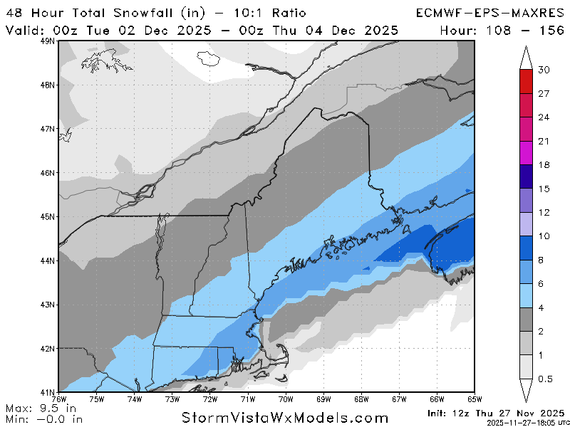
Both the Euro and GFS have the Miller B type low developing pretty far south off the NC border - a bit unusual as in recent years we have seen lows forming more north and east. Euro a bit more strung out but would if to be believed give most folks N and W of 95 their 1st measurable snow before any mix or change to rain. -
Happy Thanksgiving! 24 and light snow on and off all day. Very festive as we cook.
-
It’s a bit of a red flag but I’ve seen the AI totally out to lunch before and it has been slowly but surely ticking NW the last few runs. Watch the vort track…that usually tells you. It’s currently tracking from like central PA into LI/RI. That’s not really a big suppressed look to me. It can become suppressed if the vort/energy gets ground up too much but it’s still pretty defined in PA.
-
What happened to him?
-

December 2025 regional war/obs/disco thread
Henry's Weather replied to Torch Tiger's topic in New England
Someone should start a threat-specific thread -
Yes and no. Kinda more into it now tho because things seem to be south/colder Yup
-
-
I'm eating thanksgiving dinner, the 18z runs will be dessert... Hopefully
-
there is going to be mixing somewhere- these amounts are not accurate yet BUT GFS and Euro moved closer to their mean Ensembles - probably more adjustments to come
-

Central PA Fall Discussions and Obs
canderson replied to ChescoWx's topic in Upstate New York/Pennsylvania
F you I was going to post this exact same gif lol -
lol. That’s some internet fail. Mine is still cooking. Beer brined that bitch.
-
12z euro quite wintry looking for the metro.
-

December 2025 regional war/obs/disco thread
Kitz Craver replied to Torch Tiger's topic in New England
Take all guidance and blend and it’s a pretty nice hit for most of SNE -

E PA/NJ/DE Autumn 2025 Obs/Discussion
penndotguy replied to PhiEaglesfan712's topic in Philadelphia Region
Miller B type of setup, at least it’s something to track -
Oh yeah I know which one you're talking about, 1/19. It actually did pretty well in the medium range compared to other guidance which had the storm like 100 miles off the coast. Though I do agree it did pretty bad in the short range like you said, but it's not like any other global model did much better for that storm though
-
Euro is monthly climo snowfall for all of the folks north and west of I-95. Sign me up.
-
You just said my quiet thought out loud. The 12z gfs took a step closer to euro compared to 0z, so we’ll see if this is the start of a trend.
-
Euro like solution “feels” right to me based on seasonal trends
-
No it struggled with the one big storm we did have it was showing it as 1-3” up to like 24hrs before the event and then we got 7”.
-
If this verifies for the 3rd then statistically there'll be more to come throughout the season.
-
the one time we needed to nail a storm it didn't. but that's the euro for you
-
that looks like white rain south of White Plains, NY. We need a colder solution!
-
The Euro nailed like every storm last year, no? Other than 2/20 of course but nobody got that one right