All Activity
- Past hour
-
Yeah, this is why I like living near the shoreline. I used to get a great sea breeze back on the South Shore of LI. Now I get the local sea breezes off the Long Island Sound.
-
He’s the president of ACATT
-
Of course he posts long range gfs ops.
-
I wouldn't mind as much if highs got that high on a regular basis if: A: the dewpoints stayed below 60 B: temps would drop at sundown to the low 80s at least if not lower C: we have a nice breeze
-
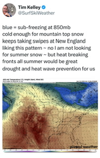
https://x.com/surfskiweather/status/1933493008810348748?s=46&t=096JqkIpgJTvSWddnDYqdA
-
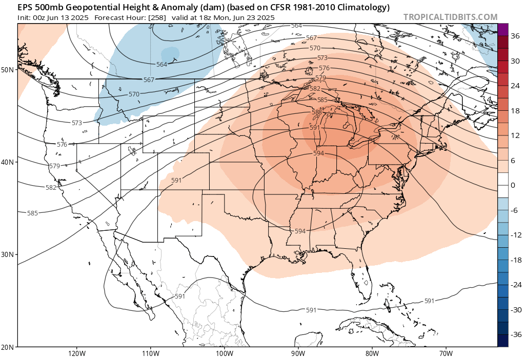
If the EPS is correct about that 594DM heat dome in around 10 days, then it would give us our first mid to upper 90s of the season.

-
Oh baby it’s coming https://x.com/jimcantore/status/1933436787159917015?s=46&t=dhcbvkjmRcyBVQtDxJ3lRg
-
Most Ambient Weather stations topped off in the low 90s in large parts of NYC, even the parts to the east where it's closer to the water and more suburban. Even the ones in the totally rural northern Nassau topped off in the low 90s.
-
I was surprised to see a flood watch for DC, PG and Southern MD. I had to water the garden for the first time yesterday. I wouldn't mind a little flood later.
-
If NYC increased the 90° count at the same rate as LGA and EWR last 30 years, then they would have around 28 days instead of only 18 days. So moving the sensor into the shade shaved off about 10 days. Yesterday was a prime example of this as some spots in NYC made it to 94° and the park was only 87°. June 12th high temperatures Corona, Queens…94° Brownsville, Queens….94° Newark….92° Astoria, Queens…91° LGA….90° JFK….90° BDR…90° FRG….89° HVN…89° ISP…..88° NYC….87° HPN….87°
-
I'll second that
-
Probably 85-90+ end of week
-
While we missed out on rain this week, the next two weeks are looking fairly warm and stormy.
-
Yup, end of the week looks like some mid-80s possibly higher in hotspots but nothing sustained. So long as it doesn't rain I'm happy.
- Today
-
3k NAM says enjoy the dry weekend. Let’s go team hrrrrr!
-
Too many people in my neighborhood have poured chemicals in their lawn. We're the only property that has them anymore in our street.
-
For the first time in 14 months, Virginia is drought free.
-
we are right on the edge of heat at times. So maybe it’s a day or two of warmth followed by fropa and N to nE winds while NJ south roasts.
-
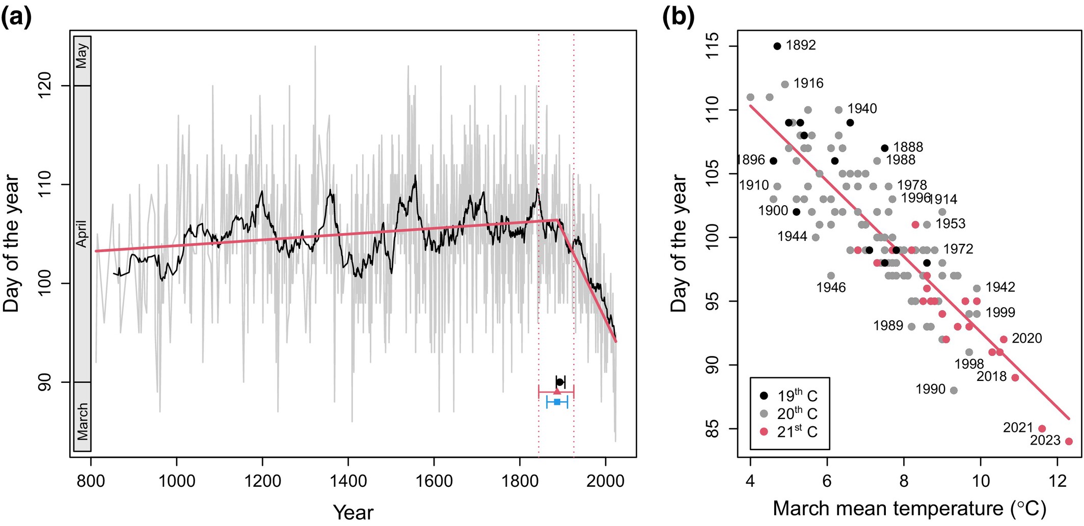
New paper analyzing the flowering date of Kyoto Cherries. Warming began to impact cherry flowering around 1890. Per the paper, urbanization and changes in cultivation are unlikely to have had much impact at that time. https://nph.onlinelibrary.wiley.com/doi/10.1111/nph.70268

-
You could be very well right on that.
-
Of course I'm not a college trained meteorologist, but I have a feeling this pattern is going to keep going for most, if not, the entire summer.
-
-
-
Hazardous Weather Outlook...UPDATED National Weather Service State College PA 430 AM EDT Fri Jun 13 2025 PAZ017>019-024>028-033>036-056-057-059-063>066-140830- Clearfield-Northern Centre-Southern Centre-Cambria-Blair-Huntingdon- Mifflin-Juniata-Somerset-Bedford-Fulton-Franklin-Perry-Dauphin- Lebanon-Cumberland-Adams-York-Lancaster- 430 AM EDT Fri Jun 13 2025 This Hazardous Weather Outlook is for central Pennsylvania. .DAY ONE...Today and tonight. Showers will become numerous later this afternoon and tonight along with isolated thunderstorms, that will bring up to one inch of rain in some places by sunrise Saturday. The main impact of the rain later today and tonight will be to prime the ground for potential flooding from additional showers and storms this weekend into early next week. .DAYS TWO THROUGH SEVEN...Saturday through Thursday. Several rounds of locally heavy rainfall could result in an increasing threat for short duration flooding Saturday and Sunday. .SPOTTER INFORMATION STATEMENT... Spotters are encouraged to report significant hazardous weather.