All Activity
- Past hour
-
Well, I just added something to my last post that may cheer you up. The models are actually suggesting a good chance this moves right back into 8 either tomorrow or the next day! So, we might go right back to celebrating!
-

December 2025 OBS and Discussion
coastalplainsnowman replied to wdrag's topic in New York City Metro
Oh we recognize a pattern alright -
Question is will the tune change 2 weeks from now or will forecasters string us along with "not too late" pieces until it's February and we're staring down a week of 70s?
-
Looks like DVN canceled the winter storm warning. 90+% of the warning area received a trace or not a flake.
-

December 2025 regional war/obs/disco thread
WxWatcher007 replied to Torch Tiger's topic in New England
Yeah better run for the region. -
Another troll
-
You have been wrong all December.
-
ENSO thread has transitioned to last rites, Philly is transitioning to last rites, Our med/long range thread is transitioning to last rites, NYC is hanging by a thread, NE isn't far behind.
-

December 2025 regional war/obs/disco thread
WinterWolf replied to Torch Tiger's topic in New England
We take. -

December 2025 Short/Medium Range Forecast Thread
John1122 replied to John1122's topic in Tennessee Valley
No sooner had I said that than thunder boomed. TIMs activated. Of course this may end as snow flakes towards morning. -
Gfs is still showing some snow for 23
.thumb.png.cbbe03ad2b86a7ff82ab498f60a87d8d.png)
.thumb.png.89f67d950462e9a3e02177c041be8e55.png)
-
The projected cold weather between Christmas and new years is quickly slipping away. Hopefully we can get a pattern reset in early January akin to January 2024 because that shook things up quite a bit and prevented a January-March 2023 repeat with an eastern ridge. Something will have to give at some point, or that’s quite the headfake the models were throwing at us
-
I think you’re right. You should probably sign off until then.
-
Gfs solid for the 23-24
.thumb.png.58b6559032e617a7b715cc71e677e2ac.png)
.thumb.png.ff1842899a8b5392b2e6a9e89dbf8732.png)
-
It just seems like the central US ridge has strengthened as we get closer to the date. Around a week ago, we knew there would be warmth across much of conus. But this record breaking warmth for much of south and central US appears to have creeped up on us, and the duration of it seems to extend past Christmas now. I think we’ll need a jet extension (I know how much we hate those) to push storminess ashore and get some storms moving throuhh CONUS. I’d rather take my chances with stormy weather and hope there’s a well timed cold air injection than to have wall to wall torch with the only winter weather being north of the border. Doesn’t get much worse than this
-
Honestly there's no chance until next month based off of what I've been seeing.
-
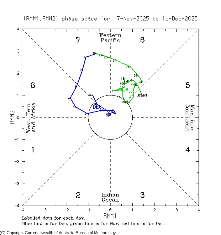
Talk about a turnaround! After one day of glee and bigtime celebration due to our immense accomplishment of getting phase 8 back, it’s already gone. The MJO moved into phase 7 two days ago. Turn out the lights, the party’s over (well as of two days ago at least). But the good news is that the models are suggesting a good chance this moves right back into 8 either tomorrow or the next day! So, we might go right back to celebrating!


-
Potential dusting/snow tv on the 23rd on the GFS. That window hasn't really lived up to my interest in it, as the heights to our west just became too hostile for something to really develop even though we still managed to scrape some cold out of the situation. But flakes would be nice.
-
December 2025 Short/Medium Range Forecast Thread
John1122 replied to John1122's topic in Tennessee Valley
That like blitzed through here. No thunder but incredible wind and heavy rain. -
This is the right question. Last year was prototyping. This year is massive telemetry gathering. Next year is tuning in response to those telemetrics. The one caveat is that observability is nascent so the value of the telemetry gathering is low but sharply increasing. So, the quality of that observability will (is) increasing exponentially, ferreting out bias, low value feedback and creating a positive feedback loop of increasing telemetry quality / observability of high-value output / input (retraining) back into the LLM’s and SLM’s.
-
Wow thanks for putting that together. Combining depth days and snow cover is a great way to look at it. 18/19 really does stick out. I recall the storms that November being a bit warmer and putting down a few feet of dense snow that really opened the whole mountain up. So I agree with Tony that it was a more impressive start than this one in some ways. While I think this early season has been special for all the reasons I mentioned earlier, it’s great to have those numbers to confirm that we aren’t really in uncharted waters here. Just in very good company with some of the better winters in the last 20 years. And wow is it always incredible to see how terrible 15/16 was.
-

December 2025 Short/Medium Range Forecast Thread
Reb replied to John1122's topic in Tennessee Valley
It feels awesome outside. MPING reports show shingle damage near Harriman and Decatur -
I mean January is 2 weeks away, prime climo window starts in 4 weeks. Could it turn around by then and the models won't pick up on it until it's closer?
-
Eff the PNA....can I get an amen?
-

December 2025 regional war/obs/disco thread
40/70 Benchmark replied to Torch Tiger's topic in New England
Still have about 1.5" of crust on the ground here....all a dream tomorrow.


.png.27c0a2391b753e6930b43554a54df774.png)
.png.678bc16becc0d8084918fb0513dda6d2.png)


.png.a55cdba7422438a113f45412a1da993d.png)
.png.a8903ba913a264a665a49bcad0484329.png)