All Activity
- Past hour
-
These gusts are insane. Have to be gusting 40-45
-
Beautiful morning out there! Humidity is noticeably lower...going to enjoy time outside later before the motherload of heat arrives.
-
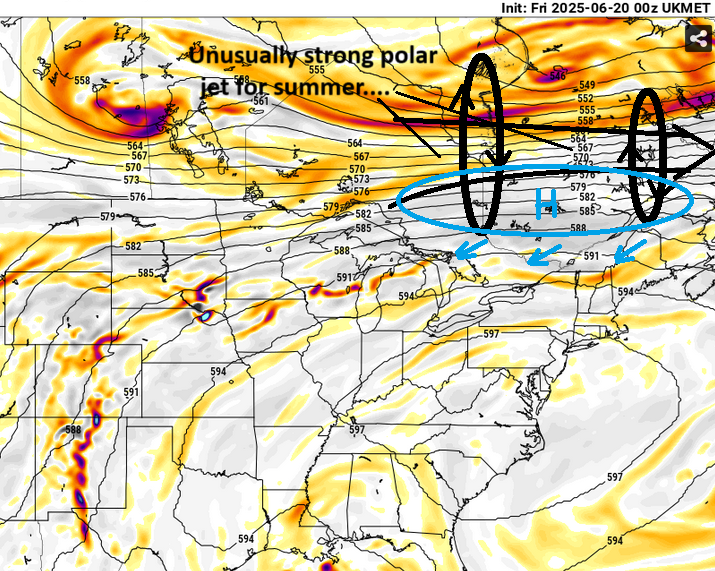
that above is why this heat may truncate mid week while that large synoptic appeal of that ridge is still in place. That models are sort of eroding the ridge out from underneath ...like water under a sandcastle. The problem is, that overactive jet (anachronistic for late June) up there fits the seasonal trend of ... basically a tendency for over active jets. There's a reason the eastern half of the mid latitude continent has just gone through the windiest AM month span in 50 years ( check that but something like that...). Anyway, these powerful jets tunneling through the skies over N Ontario will tend to mechanize polar highs ( summer versions of them...). Regardless of season, the +PP then suppresses the boundary S, under cutting the ridge, and that ends the heat. Winter or summer, the fronts seldom end up parked through here... they end up either S, or, the whole construct turns out wrong and they don't come. But at least in my experience, lodging right here is rare. It's possible the models back off this jet bomb up there...which may mitigate some of that going on.. but we'll see.
-
Beautiful morning. I’m still soft selling the Euro but I’m getting more intrigued.
-
-
I'm just playin' It's a nice morning.
-
Serious Scoot this morning
-
GSO has managed to record at least a trace of precip for the past 15 consecutive days going back to June 5th. Somehow that amounted to a MTD precip anomaly of only +.16, with the highest single day total being .64. Raleigh is at +1.02, Fayetteville +1.04, Asheville +1.28, Charlotte +.86, Danville -.49, Wilmington +.31
-
Early Fall at RDU?
-
Clouds quickly leaving here...getting into strong sun now!
-
I think he meant early fall. Late fall is the 50+ mins.
-
not a cloud here
-
He's like Ineedachill pill when it comes to snow. Both of them 'em are so out of control jazzed at all times for their respective interest area of weather, that there's no filtration of analytics at first bearing witness to some chart; they just autopost it like this guy as though it's 'totally possible'
-
NAM/Euro combo for the MCS?
-
Breeze feels nice.
-
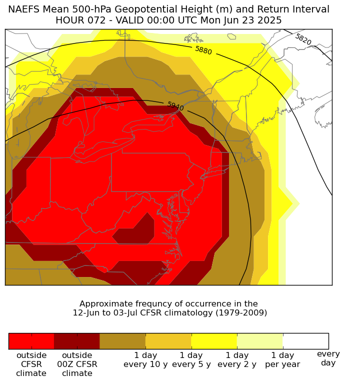
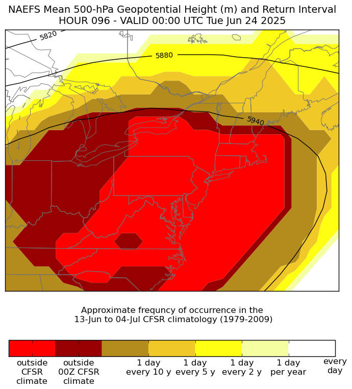
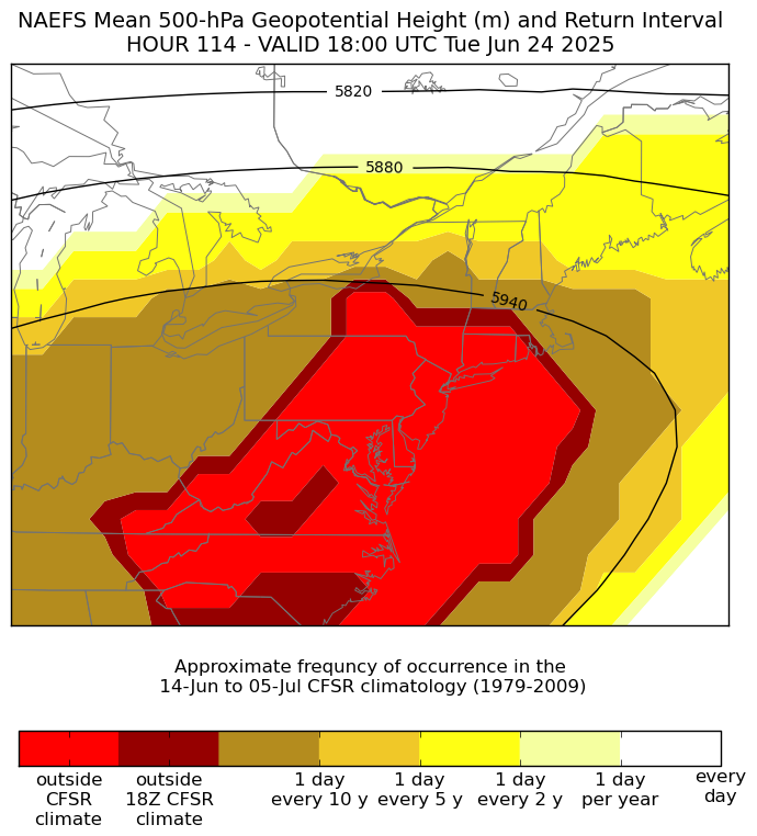
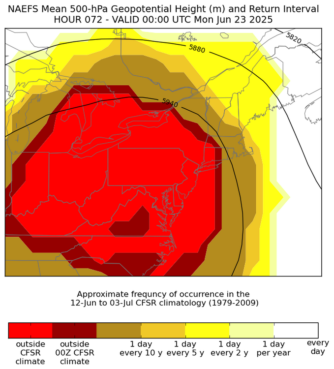
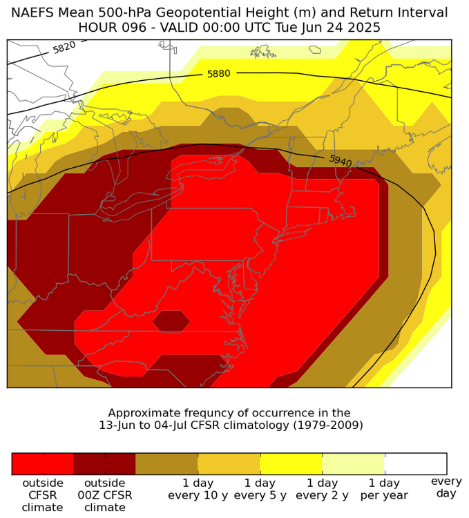
The unusual thing about the coming heatwave is how long the 500mb heights remain in the 594dm to 600dm range. In the past these ridges have generally lasted a day or two with 500mb heights this high. Now the models have us in these near to record levels from Sunday into Tuesday. Getting the heat to build for 3 days increases the chance that some spots across the region could approach 105° before the heatwave ends.

-
I looked on tropical tidbits and saw nothing.. and couldn't figure out what he was seeing
-
I have to think there will be daily seabreezes with such a contrast with the mid 60s water. The hot spot might actually be where the compressional heating is worst which could be around the Southern State Parkway area or just north. Since NW is a downslope direction it’ll definitely heat up for everyone though.
-
Healthy reminder not to get your forecast from internet wishcasters . Some were even saying hot and muggy today If you can believe that.
-
Yeah, it looked like you got a solid up that way. As for me, I got a solid too, except mine was a solid pile of excrement...lol
-
Nice pic, and yeah that's exactly how it's looked this week. We leave today so I don't think we will see any sun until we get up in the airplane above the clouds. It's back to reality in the oven when we land at DCA tonight. Acadia is nice but holy cow is it overcrowded. I don't really understand why. The facilities in the park are also woefully under designed for the number of people that show up. I might go back off season in the snow or something but I wouldn't return this time of year.
-
ahhh...I thought that looked extremely odd when I saw that. I didn't catch there was an error.
-
Come on Wiz, get it together kehd.
-
It's wrong. COD has an error. That was yesterday.