All Activity
- Past hour
-
.thumb.jpg.6a4895b2a43f87359e4e7d04a6fa0d14.jpg)
Central PA Winter 25/26 Discussion and Obs
Yardstickgozinya replied to MAG5035's topic in Upstate New York/Pennsylvania
@Ruin it's one thing if you're just simply saying you've never seen it. It's another one if you're trying to say it doesn't happen. . Every single spring and fall we have no shortage of air quality alerts on windy days, it's not a rare thing by any means. Air quality alerts in the winter is a little more rare but it's not unheard of either. Air quality alerts are frequently issued during windy conditions. While wind often disperses pollution, it can also transport smoke from distant wildfires or stir up dust, sand, and ash, causing AQI levels to spike into dangerous orange, red, or purple zones. High winds can transport pollutants across large distances, worsening air quality far from the source. Pollution and particulate matter (PM) generally travel, persist, and accumulate more in cold, dry air. Cold air is denser and sits closer to the ground, trapping pollutants, while low humidity prevents moisture from washing particles out of the atmosphere. Thermal inversions often occur, acting as a lid that keeps pollutants trapped. Humidity can help hold down pollen particles, but the overall effect on allergy symptoms is complex and often negative. While moisture can weigh down pollen grains and stop them from traveling far, high humidity often leads to increased mold and dust mite populations, which can exacerbate allergies. https://en.wikipedia.org/wiki/Dunning–Kruger_effect -
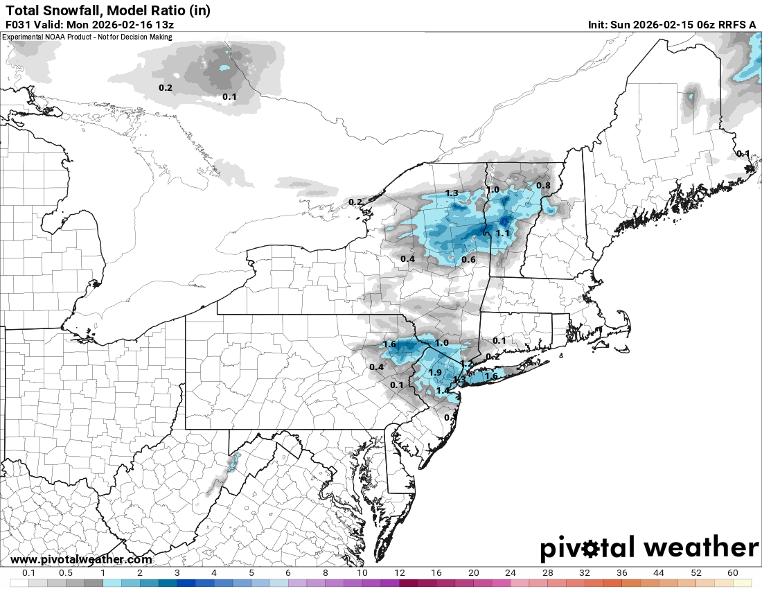
Lol it’s an inch of snow (maybe) that’s going to be gone by tomorrow afternoon when it gets into the 40’s
-
You should get some goods up there. If you have to start worrying about rain then that would be a very bad sign.
-
Oh well.. I knew it was like a 5 percent chance of happening but have to keep hope alive this week could be pretty good if things line up right
-

Central PA Winter 25/26 Discussion and Obs
Ruin replied to MAG5035's topic in Upstate New York/Pennsylvania
I never seen a bad air quaility alert in windy weather why? cause it blows stigmatic air 2 I rarely ever see it in cold weather why? the particles have a way harder time in lower humidity to bond and cause smog and or other pollution you often see in muggy very humid conditions int he summer. Myself besides from getting sick this winter I had no problems breathing at all. -

- Today
-

Winter 2025-26 Medium/Long Range Discussion
dmc76 replied to michsnowfreak's topic in Lakes/Ohio Valley
Living outside of the Lakes region for example like madison, the Quad Cities, Rockford. Even the western suburbs of Chicago. Would be frustrating to me to go days and sometimes several weeks without measureable snows. especially coming from SE Michigan, where lake-effect bursts and clippers usually give you something to track every week or two around you and watch the radar southern Michigan snows every other day while Madison and Rockford blue skies for 2-3 weeks in the same cold pattern that would drive me crazy and I know places like Minneapolis and Madison averages more than DTW but that’s DTW many places west and north of DTW averages much more outside the belts the Hills north of detroit averages 60” yes I know detroit sucks and big snowstorms (Erie Basin effect) -
Winter 2025-26 Medium/Long Range Discussion
dmc76 replied to michsnowfreak's topic in Lakes/Ohio Valley
44% of the 36.3 DTW received was under 2” events. -
For one winter, I want to live in Copenhagen, NY where they get around 300 inches of snow per year so I don't have to be up at 3:20 in the bloody morning chasing a g*ddamn inch of snow while half drunk. Never tell your significant other she would look better in the pink dress because the purple on makes her look like an eggplant.
-
Central PA Winter 25/26 Discussion and Obs
Yardstickgozinya replied to MAG5035's topic in Upstate New York/Pennsylvania
It's not fog brother. Wind can often be what's transporting pollution and particulate to you. It's all relative to where the pollution, particulate, pollen radiation, etc, source region,and you are located. It also appears to me that there is an excess amount of particulate in the air for this time of year. What you're seeing in the pictures below is not moisture or mist. I'm outside every night with a headlamp. My eyes are well, trained to tell the difference between solid particles and water droples. It's not the larger particles that actually cause the respiratory issues, It's the smaller particles making the picture look grainy, and the ones you can't see, that are responsible for the majority of respiratory and analergy issues.. Cpa is also subject to what are known as oreographic pollen and or pollution showers later in the day and night as the atmosphere cools ,due to our eastern proximitie to the Appalachian mountains . Cpa can dbe a rough place for people with allergies and health problems due to air quality ,especially when the atmosphere starts to cool after those hot and warm days in the spring and fall, when the pollen and mold counts are elevated.

-

2026-2027 El Nino
Stormchaserchuck1 replied to Stormchaserchuck1's topic in Weather Forecasting and Discussion
Climate Prediction Center - CPC adopts Relative Oceanic Niño Index (RONI) for reliable, responsive monitoring and tracking of ENSO -

Presidents' day Snow potential
Bxstormwatcher360 replied to WeatherGeek2025's topic in New York City Metro
Yeah the moisture is def north as well. -
384hr 0z GEFS Problem is where the Polar Vortex is MJO may offer some help by the 2nd week of March if it can stay amplified
-
Better than 0z
-
Slightly better than 0z
.thumb.png.db41f72d34f4e52f4e42559c51434232.png)
-
I'm inclined to agree with you regarding snow fall. One more big storm and a few more small to mid size events could really make this a very special winter in Southern New England. This week looks pretty warm the entirety into next weekend and by that I mean upper 30s to mid 40s for daytime highs and liquid precipitation
-
If we get shut out or close to it the rest of the way I think people are overrating this winter. Sure, the cold was remarkable in its duration and to some degree magnitude, but ultimately we only had the one big storm. That's pretty disappointing in my book. We did decent in the 12/26 event here but I know most of the subforum didn't do that well so really just the one widespread event. Had the Carolina crusher turned the corner then we could be talking about this winter being a special one but I think from a snowfall standpoint it may go down as largely forgettable.
-
Nothing to see
-
 Not the 0z AIFS showing another logbook fail on the 24th (and the 0z GFS too to a degree)
 -
Central PA Winter 25/26 Discussion and Obs
Yardstickgozinya replied to MAG5035's topic in Upstate New York/Pennsylvania
Apparently it's from particulate and other pollutants getting trapped under a persistent inversion facilitated by the extremely cold air we had as of late according to the NWS. -
That is just what I wanted for the sub: Deep sleet/snowpack into a deep glacier then the Bombcyclone dumping about 16 inches of fresh snow on top of the greenland-like glacier. It would have taken weeks and weeks and weeks and weeks to melt. It would have been EPIC!
-
Things are improving for the Sierras for the Sunday night thru Thursday storm cycle. Models now printing out at least 8 to 9 inches of pure water for much of the Sierran Cordillera. There are some areas of near 10 inches of the water. Snow to water ratios will start out at 8 to 11 to 1, then improve to 13 to 16 to 1 when the colder air gets in. You do the math. This is a very serious storm brewing, even for the Sierra. It's conceivable that quite a few Sierran communities will end up with seven or eight FEET of fresh snow by Thursday. This enormous snowpack will be blown around by very strong winds. This could be a particularly dangerous situation for travelers beginning Monday morning when snow rates will explode. People trying to walk to shelter in these conditions will be confronted by prohibitively deep snow and whiteout conditions caused by tremendous snow rates plus high winds and epic masses of blowing snow. This is no time to be trying to enjoy a holiday in the Sierran ski resorts. Mt Bachelor in Oregon is already beginning to see snow https://www.youtube.com/watch?v=jF9f7hsdlJg
-
It’s beautiful.
-
Central PA Winter 25/26 Discussion and Obs
Ruin replied to MAG5035's topic in Upstate New York/Pennsylvania
yeah I even had them when its windy its total bs -

Central PA Winter 25/26 Discussion and Obs
Jns2183 replied to MAG5035's topic in Upstate New York/Pennsylvania
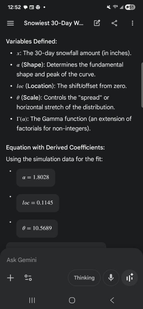
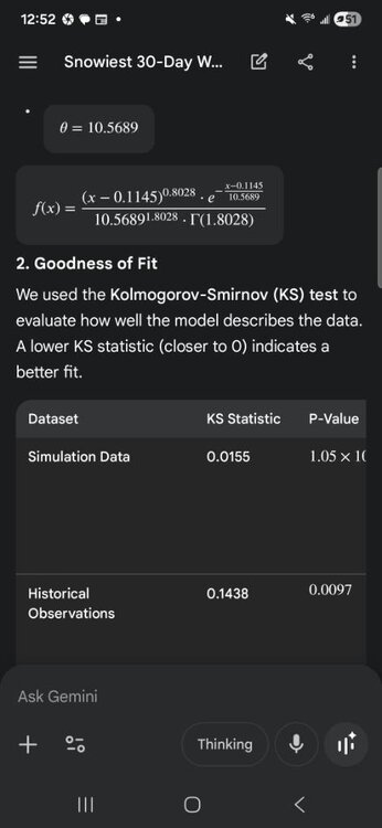
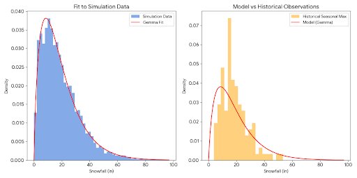
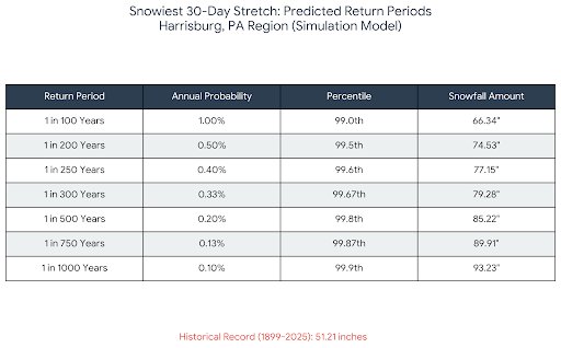
So Sam Lilo did a ridiculous million winter simulation to try to quantify what Boston experienced that fabled 30 day stretch in 2015 when 90+ inches fell in 30 days. Reaching a conclusion it was a 1:26000 year event. I did similar for Harrisburg based upon 125 years data and 30,000 simulation years. Based on the analysis of the simulation data (max30_histogram_bins_0p25.csv) and the historical seasonal maxima calculated from the Harrisburg records, the Gamma Distribution remains the best-fitting mathematical model. 1. The Model: Gamma Distribution The Gamma distribution is ideal for modeling physical quantities that are always positive and exhibit a "heavy tail" (skewed towards high values), such as extreme snowfall events. Variables Defined: * x: The 30-day snowfall amount (in inches). * \alpha (Shape): Determines the fundamental shape and peak of the curve. * loc (Location): The shift/offset from zero. * \theta (Scale): Controls the "spread" or horizontal stretch of the distribution. * \Gamma(\alpha): The Gamma function (an extension of factorials for non-integers). Equation with Derived Coefficients: Using the simulation data for the fit: * * * 2. Goodness of Fit We used the Kolmogorov-Smirnov (KS) test to evaluate how well the model describes the data. A lower KS statistic (closer to 0) indicates a better fit. | Dataset | KS Statistic | P-Value | Interpretation | |---|---|---|---| | Simulation Data | 0.0155 | 1.05 \times 10^{-6} | Excellent Fit. The model follows the simulation counts almost perfectly across the entire range of values. | | Historical Observations | 0.1438 | 0.0097 | Moderate Fit. The model generalizes the history but over-predicts low-snow years and under-predicts the mid-range "typical" snowiest months. | 3. Analysis * Simulation vs. Model: The Gamma curve is a near-perfect approximation of the simulation data. It successfully captures the rapid rise in probability between 0 and 10 inches and the long, thin tail extending past 60 inches. * Historical Gap: As shown in the right-hand graph, the historical observations are more "clumped" than the model predicts. In reality, Harrisburg has a very strong peak of seasonal maxima between 15 and 25 inches. The model (derived from simulation) peaks slightly earlier (around 10 inches). * Extreme Tails: The simulation model is much "bolder" than the historical record. It suggests a non-zero probability of 30-day periods exceeding 80 inches, whereas the historical record (spanning ~126 years) has never surpassed ~51 inches. * Conclusion: The equation is a highly reliable model for the theoretical distribution of 30-day snowfall. However, if used to predict a typical winter in Harrisburg, it will slightly underestimate the "average" peak snow month while significantly overestimating the potential for unprecedented "megastorms." Sent from my SM-S731U using Tapatalk


.png.7922f5e12d363fbbb0b222780025b0aa.png)