All Activity
- Past hour
-
When the trend is your friend.
-

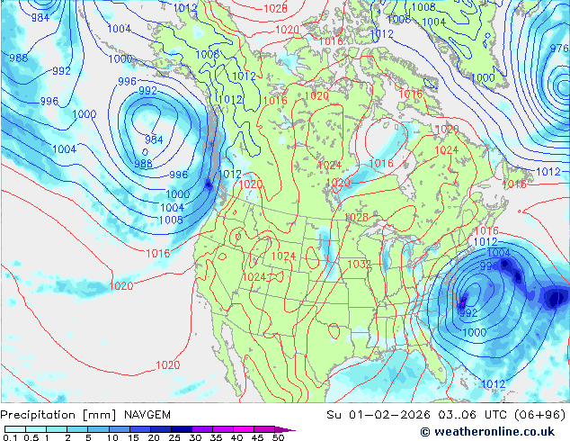
Possible coastal storm centered on Feb 1 2026.
Roger Smith replied to Typhoon Tip's topic in New England
Buy citrus soon, prices will skyrocket next week. (Florida freeze coming) -

February 2026 Medium/ Long Range Discussion: Buckle Up!
Maestrobjwa replied to Weather Will's topic in Mid Atlantic
Came in here to talk about the same thing...like bruh whhhyyy? Lol (If it does end up looking like that we'll know this time to ignore the threat altogether! -
The Jan 31 Potential: Stormtracker Failure or 'Tracker Trouncing
Roger Smith replied to stormtracker's topic in Mid Atlantic
I was reading about the Washington and Jefferson snowstorm of Jan 28, 1772, apparently both of those esteemed gents were weather watchers and measured 30 inches of snow at both of their locations. There were some gnarly winters around the Revolutionary War period, Jan 1780 was extremely cold and the Hudson River froze over solid. A reading of -16 F was taken somewhere near New York City. That image earlier in the thread reminded me of these factoids. Other winters of the early years that were very harsh were 1805 and 1821. They had dud winters in those times too, a weather journal from Rhode Island shows that winter 1833-34 was very mild and almost without snow. Winters of the 1850s were very cold and snowy but the 1840s were much more variable. In this era of human-modified climate some may forget that there are large natural variations in the mix as well. -
sounds like right in front of the garage is a good place to dump snow for next time
-
It doesn’t need much of a jog west. .
-
.thumb.png.4150b06c63a21f61052e47a612bf1818.png)
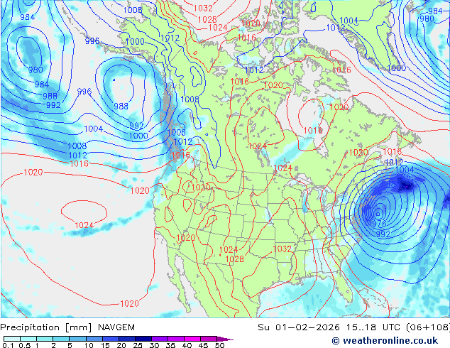
Possible coastal storm centered on Feb 1 2026.
HIPPYVALLEY replied to Typhoon Tip's topic in New England
Something different from what the models are showing right now is going to happen for sure. I’m not convinced it will be big for us, but they are definitely going to be some surprises over the next 48 hours. -

Possible coastal storm centered on Feb 1 2026.
George001 replied to Typhoon Tip's topic in New England
I’m not buying this eastern trend at all. Something big is going to happen this weekend. -

Richmond Metro/Hampton Roads Area Discussion
eaglesin2011 replied to RIC Airport's topic in Mid Atlantic
Imo I would rather the storm just blows up farther south in NC & the precip field expands north.. I’d rather just have a nice average 3 to 6 snowfall then have this move more north but the development hurt us and send dry air into this specific area… I think that is what the models are having a hard time predicting… -

The “I bring the mojo” Jan 30-Feb 1 potential winter storm
Snowncanes replied to lilj4425's topic in Southeastern States
Yeah… I think it’s overdoing it though. CAM’s will probably resolve it better but I feel like a low that strong is going to throw precip back. And if we can get even just a slightly earlier negative tilt it will help transfer the energy earlier and throw the precip back over the piedmont better. The gap is from the ULL snow and the energy skipping over and then the low bombing out and so that area misses the brunt of the ULL and of the coastal. -
Possible coastal storm centered on Feb 1 2026.
HIPPYVALLEY replied to Typhoon Tip's topic in New England
Verbatim, would get some accumulating snow pretty far west. -

February 2026 Medium/ Long Range Discussion: Buckle Up!
stormtracker replied to Weather Will's topic in Mid Atlantic
lol, Euro tries the EXACT same thing Next Saturday as it's doing for this Saturday. Can't make this shit up. Same result -
Probably time for a February thread. The Euro is already trying to shaft us with a system next week that looks about like this one. Weak sauce here and it buries NE Georgia, South Carolina and North Carolina. Meanwhile, the GFS gives us rain and smokes southern Kentucky with 6 inches. So we are right in the middle of the two, but we know it'll either fade far south or go north.
-
 Why does the Euro hate Greenville? Did they make God angry?
 -

The “I bring the mojo” Jan 30-Feb 1 potential winter storm
StantonParkHoya replied to lilj4425's topic in Southeastern States
Don’t love the dry slot between Raleigh and Highway 17 . -
The butthurt DC area folks are a bit annoying, so Im popping my RVA area ass over here to see what's up. Hell, I'm interested even if Richmond only gets a few inches
-
You could have the issues Carvers mentions, but across all modeling you're looking at 4-10+ inches at this point.
- 230 replies
-
- 1
-

-
- extreme cold
- snow
- (and 1 more)
- Today
-

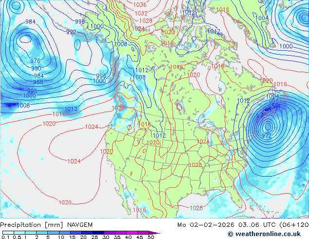
The Jan 31 Potential: Stormtracker Failure or 'Tracker Trouncing
snowcane33 replied to stormtracker's topic in Mid Atlantic
Awesome, it seems too me that you think they will win it all this year. Go O's!!!! Hopefully things will change today with these models to at least give the eastern shore some love today. Let's go fern!!! -
Only model with a hit is the 0z navgem so far. This model did pretty damn well in the last storm we had.
-

1-30/2-1-26 Arctic Blast, ULL Snow Event
Hurricaneguy replied to John1122's topic in Tennessee Valley
John, how is your gut feeling about Greeneville/Greene Co? Is this finally looking like the storm to give us a solid snowfall? At least 3-4” -
I think its amazing how some posters here are just "throwing in the towel" on this storm like there is no chance of any snow when parts of the region could still receive anywhere from 2 - 8 inches AS OF NOW or more if there is a slight northwest jog of less than 100 miles. if you receive 4 -8 inches it will seem like a bigger deal because of all the snow already on the ground and frozen solid piles and VERY cold temps. The only good thing is it would be overnight Saturday once again very little traffic and Sunday a majority of people don't have to go to work or school. I also think the title of this thread is misleading - FYI it could be coming but only a smaller event than previously expected.
-

Richmond Metro/Hampton Roads Area Discussion
wasnow215 replied to RIC Airport's topic in Mid Atlantic
3-6" Kuchera -it's fine-wind gusts approaching 40 much of the time also -
And by stepped back, I mean for those of us in the screw zone/western edge. It still pounds the far eastern areas with 6-10 inches.
- 230 replies
-
- 1
-
-
- extreme cold
- snow
- (and 1 more)
-
Well, this may be nothing, but the Euro actually looks decent. But that it is pretty much the only model holding serve right now.
-

The Jan 31 Potential: Stormtracker Failure or 'Tracker Trouncing
Nomz replied to stormtracker's topic in Mid Atlantic
Rutschman is remaining a pumpkin Westburg is overrated Beavers and holliday have no tools Alonso regression + horribly aging + no fielding Cowser is playing in japan next year Basallo Ks too much Ward can pop a HR once and a while but thats it Trevor Rogers due for BABIP regression Kyle Bradish has had one (1) healthy season Baz and Eflin are Rays name brand merchants Dean Kremer is Israel's greatest soldier Bullpen is Ryan Helsley and a bunch of slapdicks


