All Activity
- Past hour
-
Seems like the sort of pattern where we may get frequent shots at light accumulation but no big storm threat.
-

January 2026 regional war/obs/disco thread
40/70 Benchmark replied to Baroclinic Zone's topic in New England
Yea, I could see that...I have not, and won't even look at this...just try not to have it be a PIA. lol -

January 2026 regional war/obs/disco thread
ineedsnow replied to Baroclinic Zone's topic in New England
I'm still mostly in bed with the flu.. today seems better though.. this is the one time I wish it was warm out -
January 2026 regional war/obs/disco thread
Typhoon Tip replied to Baroclinic Zone's topic in New England
what? my thoughts are pure logic dude - at the moment anyway... nah, CC HAS nothing to do with why I cited MJO desk, and these other facts in present company and stream. lol, not sure we're even disagreeing on much here. -

January 2026 regional war/obs/disco thread
ORH_wxman replied to Baroclinic Zone's topic in New England
You are really close to the snow line too early on so I don’t think it will just be ZR. Prob some sleet and perhaps mangled flakes mixed in. Basically a potpourri of crap. It’s not a lot of QPF but obviously even a little ZR makes things ugly. And yeah, roads will be fine as long as they are treated. Sidewalks might be another story. -

January 2026 regional war/obs/disco thread
40/70 Benchmark replied to Baroclinic Zone's topic in New England
I also don't think this particular La Nina is a good specimen to test these theories because it's never been particularly robust. -
anyone know the NyC December temp +-?
-
Happy 30th anniversary all!
-

January 2026 regional war/obs/disco thread
SouthCoastMA replied to Baroclinic Zone's topic in New England
Its still 32.7° here. Theres no way northern MA goes above freezing. -

January 2026 regional war/obs/disco thread
WinterWolf replied to Baroclinic Zone's topic in New England
Go with the tenor… -

January 2026 regional war/obs/disco thread
40/70 Benchmark replied to Baroclinic Zone's topic in New England
I agree with John that this is unlikely to be a La Nina like late season...we can leave it at that. -
Nice to see the AO staying negative. - EPO later
-

January 2026 regional war/obs/disco thread
ineedsnow replied to Baroclinic Zone's topic in New England
some said that wouldn't happen a few days ago -

January 2026 regional war/obs/disco thread
40/70 Benchmark replied to Baroclinic Zone's topic in New England
Ice all night? I'll believe that when I see it....if it is, it will probably be a situation where it accretes on surfaces that no one cares about, like mailboxes.... -
A warm day this Friday
-

January 2026 regional war/obs/disco thread
WinterWolf replied to Baroclinic Zone's topic in New England
You and Tip can argue semantics, but I like my winters to last through all of Feb-which just happens to be our snowiest month here in SNE, so I hope that happens, whether Niña is dead or not lol. So Let’s rock this upcoming peak climo this year. -
Not sure where to put this. Mods, please move if you feel it should go elsewhere. I just saw this today and wanted to make people aware. The AFD format will be changing on 1/12/2026. https://www.weather.gov/media/rah/modernizedAFD.pdf
-

January 2026 regional war/obs/disco thread
ORH_wxman replied to Baroclinic Zone's topic in New England
It won’t be. -
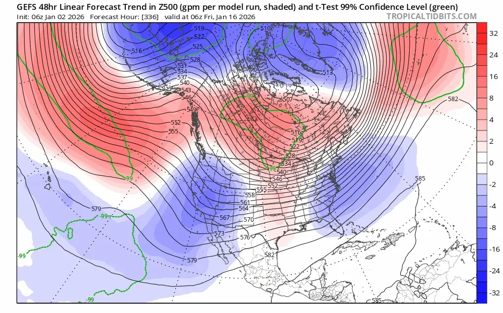
The ^ is near the time of the elongated PV. moving SE towards Hudson Bay.
-
This is not a forecast but rather food for thought. Looking ahead, definitely appears winter will return after this coming January thaw. As to what happens Feb and beyond idk, but Feb in Ninas can be great months for winter storms in our region.....they also have a tendancy for a torch (esp late Feb) before March sees winter roar back (and we are due for a snowy March).
-
LOL
-

January 2026 regional war/obs/disco thread
40/70 Benchmark replied to Baroclinic Zone's topic in New England
I hope it's plain rain here. -

January 2026 regional war/obs/disco thread
40/70 Benchmark replied to Baroclinic Zone's topic in New England
MEI does....and like I said, assuming it is dead, there is a reason that the ONI encompasses a tri-monthly period. I understand you are dug in on this given your thoughts on CC....I get it. We don't always have to agree on everything. -
-
January 2026 regional war/obs/disco thread
Typhoon Tip replied to Baroclinic Zone's topic in New England
mmm... in this case, not sure agree. peppeRONI or not, the pizza isn't getting cooked with ENSO if it is decoupled. RONI does not mean there's some presence when the ENSO is decoupled. It means the coupled state is augmented and really shares a quasi state. That weird N. Pac thing that lasted 4.5 weeks or whatever eternity that was ... didn't strike me as either to be honest.


