All Activity
- Past hour
-
What model runs would start to import that data into their solutions?
-
Sleep right through the storm?
-

Richmond Metro/Hampton Roads Area Discussion
mikeeng92 replied to RIC Airport's topic in Mid Atlantic
-

“Cory’s in NYC! Let’s HECS!” Feb. 22-24 Disco
Baroclinic Zone replied to TheSnowman's topic in New England
00z HRRR slays looks like timing is a bit slower than 18z run. -
Looks like it includes snow next week but still, crazy. .
-
2/21 21z SREF Total QPF mean 2/22-2/23-24 Snow 10:1
-
-

“Cory’s in NYC! Let’s HECS!” Feb. 22-24 Disco
mahk_webstah replied to TheSnowman's topic in New England
He’s my hero -

Feb 22nd/23rd "There's no way..." Obs Thread
Paleocene replied to Maestrobjwa's topic in Mid Atlantic
it owned thermals a month ago, and was pretty dead on with respect to when I was supposed to flip to sleet for the snowcrete dump. Levels upstairs are all great, we need the coastal to crank and rates to drop temps at the surface. I am choosing to believe the NAM that if things can get going by 1pm, I'll be seeing white rain IMBY at least -

“Cory’s in NYC! Let’s HECS!” Feb. 22-24 Disco
ineedsnow replied to TheSnowman's topic in New England
NAM not as amped as 18z -
Coastal could be getting going a smidge earlier this run? Have to double check 18z
-
It might! The Alberta vort did a clean phase. It's a triple phaser.
-

Feb 22nd/23rd "There's no way..." Obs Thread
snowmagnet replied to Maestrobjwa's topic in Mid Atlantic
Yes! -
That's forky verified numbers right there.
-

Feb 22nd/23rd "There's no way..." Obs Thread
Solution Man replied to Maestrobjwa's topic in Mid Atlantic
997 of Delmarva, just noise, could be a little drier…let’s see -

The February 22-23 Late Season Miracle: JV Disco/Banter Thread
Wxtrix replied to bncho's topic in Mid Atlantic
oh thank God. i have been fretting all day not knowing what the weather was going to be in Pennsylvania. -
There’s a lot of people that don’t understand how different this storm will be as modeled when compared to other coastal storms that provided a lot of snow to the area. I am telling family out on LI to think of this as a hurricane that brings snow. The modeled intensity speaks for itself. I also introduced them to a new word for their vocabulary- Bombogenesis. The map below with the expected winds off the latest HRRR run speaks for itself. And yes it does have an eye.
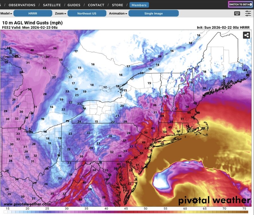
-
“Cory’s in NYC! Let’s HECS!” Feb. 22-24 Disco
ineedsnow replied to TheSnowman's topic in New England
storm will be over but Thursday night will be in view hmmm -

Blizzard of 2026 Storm Thread/OBS
Ralph Wiggum replied to Mikeymac5306's topic in Philadelphia Region
I see what you did there. Well-played -
Glad I installed a standby generator in 2016 agreed my house was built. Smartest investment anyone should do
-

The February 22-23 Late Season Miracle: JV Disco/Banter Thread
IronTy replied to bncho's topic in Mid Atlantic
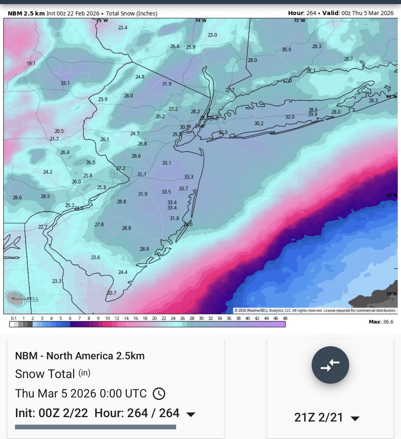
This map is refreshingly easy to read by DT standards. -

-
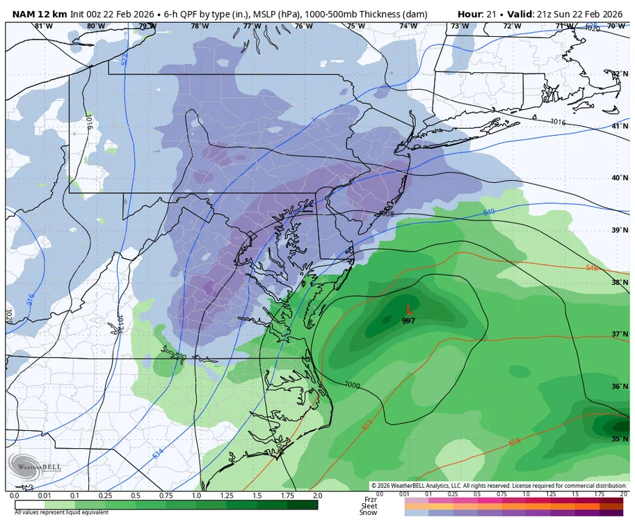
No. Because the 12k is trash.
-
Blizzard of 2026 Storm Thread/OBS
Ralph Wiggum replied to Mikeymac5306's topic in Philadelphia Region
Sure does....light but still snowing -
“Cory’s in NYC! Let’s HECS!” Feb. 22-24 Disco
ineedsnow replied to TheSnowman's topic in New England
Im at work for 12z