All Activity
- Past hour
-
Rise of the Machines: January 18-19 Winter Storm Obs Thread
Dalfy replied to WxWatcher007's topic in New England
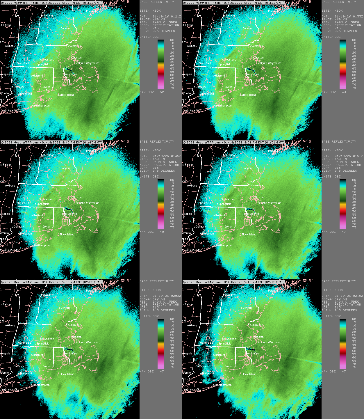
Started snowing lightly in lebanon perhaps an hour ago. Dusting on my car thus far, very fine powder. 30 F -

Storm potential January 17th-18th
NorthShoreWx replied to WeatherGeek2025's topic in New York City Metro
North Smithtown 9:30pm 2.4" This is for Sunday. 40.88, -73.21 -
Rise of the Machines: January 18-19 Winter Storm Obs Thread
Masswx replied to WxWatcher007's topic in New England
T blizz has twice my amount and I don’t know how -
Rise of the Machines: January 18-19 Winter Storm Obs Thread
Masswx replied to WxWatcher007's topic in New England
Still at around 2.25 pretty bad snow growth in last half hour but hoping to get better growth and bands later i need this storm to work out a little better than it had -
I’m an idiot. 1.7 yesterday. So 4.2 total for the weekend. Not bad. 2.5 as of 9:00.
-
Carver; would this system be apart of the energy that dumped record snows in Russia? .
-

January 2026 Medium/Long Range Discussion
nw baltimore wx replied to snowfan's topic in Mid Atlantic
I think it was Gordon Barnes that loved using the term “double barrel.” Maybe Bill Kamal, but I think it was GB. And one of them also often said, “It’s a case of Peter robbing Paul,” referring to a dying Appalachian low transferring too far off the coast. -

Rise of the Machines: January 18-19 Winter Storm Obs Thread
Ginx snewx replied to WxWatcher007's topic in New England
3 new moderate 31⁰ -
This final band is exploding, could drop a quick inch. Came out of nowhere
-

Rise of the Machines: January 18-19 Winter Storm Obs Thread
Torch Tiger replied to WxWatcher007's topic in New England
Not sure if we're under the better returns, but <1/2mi. vis here -
The good news is both AI models actually went The other way and was more amped at 18z compared to 12.
-

Storm potential January 17th-18th
wthrmn654 replied to WeatherGeek2025's topic in New York City Metro
1-1.5 inches new tonight on top of .25 this morning. -
January 18th Back Door NW Trend Snow OBS Thread
RU848789 replied to Mikeymac5306's topic in Philadelphia Region
Since I live at the edge of the Mt. Holly CWA, here's my final post on the storm... We got 2.4" of new snow this evening for a total of 4.1" today and 5.8" over two days, which I'm ecstatic about. Another very pretty snow as it wasn't windy and the snow was wet enough to stick to the trees. Going to finish watching the football game and then go shovel. -
I weenie’d myself earlier for talking about roads icing up tonight, but side streets are a legit disaster.
-

Rise of the Machines: January 18-19 Winter Storm Obs Thread
ORH_wxman replied to WxWatcher007's topic in New England
-
Thanks Ron
-
Of note, the 18z EPS and EPS AIFS are super similar. The AI is a tick north, but not by much. I can't say I like the trend for E TN at 18z, but we have a ways to go before that gets nailed down. A big trend north or warm nose tomorrow, and I will politely hand this off to the middle and west guys(same for most recent Nina winters!).....again, probably need 3-4 more runs to really get a good handle on where that nose sets up shop. All great storms have the warm nose....need that high to build in. HOWEVER, I do worry a little about suppression w/ the 18z GEFS and EPS losing moisture transport northward....so let's worry about it all. Haha.
-
Storm potential January 17th-18th
winterwarlock replied to WeatherGeek2025's topic in New York City Metro
About 3 inches today -
Storm potential January 17th-18th
sussexcountyobs replied to WeatherGeek2025's topic in New York City Metro
Snow has ended. 3.3" total. 24.5° 27.7" for the season. Half way there for average. Plenty of winter yet to come. -
Yea this evenings batch sucked big time. Maybe we squeeze another 1/2”
-

Rise of the Machines: January 18-19 Winter Storm Obs Thread
Torch Tiger replied to WxWatcher007's topic in New England
Nice band going 495 ish -
FWIW. From a respected met Mike Masco..about the upcoming storm ANOTHER STORM SIGNAL NEXT WEEKEND? As one storm exits, another is already on the radar. And once again, the AI European model deserves some credit — it sniffed out our most recent storm well before any of the traditional, physics-based guidance. Now the AI-EURO is back, flashing a storm signal for a southern low tracking east across the country NEXT WEEKEND. What the model is showing: Phasing of the northern & southern jet streams over the TN Valley as a northern shortwave diving in and infusing southern energy. This creates a surface low tracking along the arctic boundary in place later this week. We consider this track a classic “Southern Slider” setup with plenty of cold air in place to the north with moisture binding against the gradient. What could go wrong? 1. Too much cold air → storm suppressed south (big snow for the Deep South) 2. No phasing → weak, disorganized system 3. The model is… full of it (and we crowned it too early) Why this could be legit: 1.MJO heading into Phase 8 — historically favorable for eastern U.S. storms 2.Guidance is very bullish on cold air, usually tied to strong thermal gradients 3. Blocking signals showing up on both the West Coast and western Atlantic
-
Storm potential January 17th-18th
RU848789 replied to WeatherGeek2025's topic in New York City Metro
Calling it over at 8:45 pm, as the snow became light around 8:20 pm and looks like it'll be just flurries from here on with precip ending shortly, unless there's a surprise. Anyway, we got 2.4" of new snow for a total of 4.1" today and 5.8" over two days, which I'm ecstatic about. Another very pretty snow as it wasn't windy and the snow was wet enough to stick to the trees. Going to finish watching the football game and then go shovel. -
As snow ends now, we had around 0.7" earlier, and around 1.7" tonight. So that's a total of 2.4". With the 1.1" yesterday, that's 3.5" for the weekend. I wasn't expecting anything yesterday so I guess that makes up for today's bust. Around 13.5" for the season (1 inch shy of last winter's final total.)
-
1 inch this evening total for the day here 1.75. Was expecting more this evening.


