All Activity
- Past hour
-

Central PA Fall Discussions and Obs
mahantango#1 replied to ChescoWx's topic in Upstate New York/Pennsylvania
-

Central PA Fall Discussions and Obs
mahantango#1 replied to ChescoWx's topic in Upstate New York/Pennsylvania
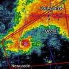
Hazardous Weather Outlook National Weather Service State College PA 422 AM EDT Thu Oct 30 2025 PAZ036-056-057-059-063>066-310830- Franklin-Perry-Dauphin-Lebanon-Cumberland-Adams-York-Lancaster- 422 AM EDT Thu Oct 30 2025 This Hazardous Weather Outlook is for central Pennsylvania. .DAY ONE...Today and tonight. Strong to severe thunderstorms with gusty winds and even an isolated tornado are possible late this morning and afternoon. Wind gusts may exceed 40 MPH at any time today, especially on the higher hill tops. .DAYS TWO THROUGH SEVEN...Friday through Wednesday. The probability for widespread hazardous weather is low. .SPOTTER INFORMATION STATEMENT... Spotters are encouraged to report significant hazardous weather. -
It’s normally quite easy to get decent rain around here. Now if this were happening in winter this wouldn’t be a slam dunk for a big snow because there’s more to go wrong when it comes to that.
-
E PA/NJ/DE Autumn 2025 Obs/Discussion
BBasile replied to PhiEaglesfan712's topic in Philadelphia Region
Up to 0.40" of rain so far. Wind gusts to 24 MPH. 56F. - Today
-
Hoo boy - so weird to actually get a notable system. So much rain, Regionals for boys and girls hs cross country is this afternoon at pikesville HS and that route is gonna be an absolute mess
-
Reminder to NYC participants to visit contest thread with or without costumes by 31st.
-
Major Hurricane Melissa - 892mb - 185mph Jamaica landfall
Windspeed replied to GaWx's topic in Tropical Headquarters
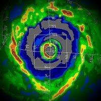
Huge thanks to Brian McNoldy at the Rosenstiel School of Ocean and Atmospheric Science at Miami for editing the full loops together for which I sourced these. I am posting these for posterity. Rarely do we have radar loops that show full eyewall mergers instead of eyewall replacement cycles. I will post both the short range and long range. Keep in mind the short range has limited/degraded echoes due to distance. But you can still make out the moat and concentric outer band/eyewall that was organizing in Melissa prior to the inner eyewall becoming dominant and absorbing them. The only other intense hurricane that we have radar evidence of this phenomenon is Irma prior to its landfall in the Lesser Antilles. There is much to be learned about these type of events and how they occur. Most likely, when environmental conditons are near to perfect/pristine and an inner eyewall reaches a certain degree of stability, it will not succumb to outer concentric banding, but pull those bands in and absorb them. As we can see Melissa do in these loops, the dominant eyewall becomes extremely intense after the final merger before it goes on to become a sub 900 hPa hurricane. There is probably a doctorial degree for someone here. It just requires extensive research. Short range: Long range: -
Huh. Just got a clap of thunder near Gainesville.
-

Spooky Season (October Disco Thread)
H2Otown_WX replied to Prismshine Productions's topic in New England
There's the kiss of death. December 2001/2011 incoming. -

Major Hurricane Melissa - 892mb - 185mph Jamaica landfall
Coach McGuirk replied to GaWx's topic in Tropical Headquarters
Mellissa was a tiny hurricane, most cat 5s are that way. -
Major Hurricane Melissa - 892mb - 185mph Jamaica landfall
GaWx replied to GaWx's topic in Tropical Headquarters
For much of the time hurricane force winds extended outward only 30 miles. Now it is up to 60 miles while TS force extend about the same as they’ve been: From NHC 11PM advisory: Hurricane-force winds extend outward up to 60 miles (95 km) from the center and tropical-storm-force winds extend outward up to 185 miles (295 km). -

Major Hurricane Melissa - 892mb - 185mph Jamaica landfall
Coach McGuirk replied to GaWx's topic in Tropical Headquarters
I think it was this typhoon. He deleted the part when his friend was injured and the glass blew out. -
Right at 1 inch down here now... Cold rainy night...
-
The 18z GFS around D11 had a 1-3 inch snow for the Plateau/SWVa with more along the mountains. Around .5 to 1 inch for most of the mid-state. One of the first shots fired for accumulating snow across the lower elevations. The 12z had it but over a smaller area. Basically less than a half inch over Campbell/Scott/SE Ky/SWVa and heavier snow in the higher eastern mountains. I doubt it will still be there on the 0z.
-
1.1 inches of rain today, 3.6 inches this week so far.
-
Major Hurricane Melissa - 892mb - 185mph Jamaica landfall
GaWx replied to GaWx's topic in Tropical Headquarters
-

Major Hurricane Melissa - 892mb - 185mph Jamaica landfall
OrangeCTWX replied to GaWx's topic in Tropical Headquarters
It seems like it takes a special breed lol Reed Timmer with tornados, Josh with hurricanes etc. -

Major Hurricane Melissa - 892mb - 185mph Jamaica landfall
Coach McGuirk replied to GaWx's topic in Tropical Headquarters
It was a direct hit on Taiwan as a cat 5 in hurricane terms. I can't believe this storm has been scrubbed. Josh was there. -
RAIN sheets of heavy rain now
-

Major Hurricane Melissa - 892mb - 185mph Jamaica landfall
Coach McGuirk replied to GaWx's topic in Tropical Headquarters
Maybe it was Morokat after all. I thought it was later. -

Major Hurricane Melissa - 892mb - 185mph Jamaica landfall
Windspeed replied to GaWx's topic in Tropical Headquarters
Ok, hrmm... I might be getting some of his old footage mixed up. I think I'm confusing that with when Reynolds was chasing with him. -

Major Hurricane Melissa - 892mb - 185mph Jamaica landfall
Coach McGuirk replied to GaWx's topic in Tropical Headquarters
No it was Taiwan probably 10 years ago. -

Major Hurricane Melissa - 892mb - 185mph Jamaica landfall
Windspeed replied to GaWx's topic in Tropical Headquarters
I think what you are describing was when Super Typhoon Haiyan made landfall near Tacloban, Philippines. Come to think of it, that means Josh has been in the most intense Pacific landfall and the most intense Atlantic landfall in the satellite era. -

Major Hurricane Melissa - 892mb - 185mph Jamaica landfall
Coach McGuirk replied to GaWx's topic in Tropical Headquarters
I remember he was chasing a very strong Typhoon that hit Taiwan. The hotel he was in got blown out and his friend got serious cuts on his arm.


