All Activity
- Past hour
-
I agree.
-
07-08 was a shit show south of New England
-
54 / 41 clear off a low of 46. Upper 60s / low 70s in the warmest spots - over exceeding highs/ sun-dryness. Flow comes around warming Fri back to the 70s and upper 70s to low 80s / mid 80s in the warmest areas Sat - Tue. Front on Wed (10/8) and next rain chance with cooling back near / slightly above normal. Euro rebuilds ridge and warmth / strong warmth by the 10th and beyond, GFS a bit cooler / near normal. 10/2 - 10/3 : Cooler / warmaing back to normal/ above 10/4 - 10/7 : Warm / much warmer than normal (80s) mid 80s in warmest areas, maybe warmer 10/ 8 - 10/10 : Cooler - near normal (rain chances wed with front >0.25 inches 10/11 - beyond : Overall warmer (Euro is much warmer 10/11 - 10/13)
-

Spooky Season (October Disco Thread)
Typhoon Tip replied to Prismshine Productions's topic in New England
While it's certainly enough to delay any affectation of seasonal change ... I'm not seeing that the 850 mb/lower thickness intervals as being very excessive - relative to climo. It seems the models are trying to pack most of this late heat spell into the 500 mb heights. Sometimes I wonder if the modelers put coefficient muting factors into the framework. Control run-away excessive scenarios from taking off. Like "synergy" blockers. Whatever it is, the 500 mb non-hydrostatic impression alone looks straight up like a streak of days hosting record breaking temperatures... But, the lower troposphere is being held too cool to realize that. In 2020 ( and I think last year too - ), we saw 80F in the first two weeks of November. It's not too late to cook up some heat. Things have to be ideal though this late. -
This is weird with the first half of the month so cool. I just can't picture this as a hot September, certainly nothing like the historic 1983 (which was a true wall to wall summer for 4 months.)
-
Places like Islip just had their 3rd warmest September with record heat later in the month. Climatological Data for ISLIP-LI MACARTHUR AP, NY - September 2025 Click column heading to sort ascending, click again to sort descending. Sum 2344 1841 - - 7 156 1.58 0.0 - Average 78.1 61.4 69.8 2.9 - - - - 0.0 Normal 74.8 58.9 66.9 - 53 108 3.60 2025-09-01 77 57 67.0 -4.2 0 2 0.00 0.0 0 2025-09-02 78 58 68.0 -3.0 0 3 0.00 0.0 0 2025-09-03 76 56 66.0 -4.8 0 1 0.00 0.0 0 2025-09-04 78 58 68.0 -2.5 0 3 0.00 0.0 0 2025-09-05 81 68 74.5 4.2 0 10 0.29 0.0 0 2025-09-06 82 67 74.5 4.5 0 10 0.39 0.0 0 2025-09-07 67 60 63.5 -6.2 1 0 0.41 0.0 0 2025-09-08 74 56 65.0 -4.5 0 0 0.00 0.0 0 2025-09-09 74 53 63.5 -5.7 1 0 0.00 0.0 0 2025-09-10 74 64 69.0 0.1 0 4 0.01 0.0 0 2025-09-11 81 57 69.0 0.4 0 4 0.00 0.0 0 2025-09-12 79 61 70.0 1.8 0 5 0.00 0.0 0 2025-09-13 76 58 67.0 -0.9 0 2 0.14 0.0 0 2025-09-14 79 62 70.5 2.9 0 6 0.00 0.0 0 2025-09-15 82 63 72.5 5.2 0 8 0.00 0.0 0 2025-09-16 76 63 69.5 2.6 0 5 0.00 0.0 0 2025-09-17 74 64 69.0 2.4 0 4 T 0.0 0 2025-09-18 83 66 74.5 8.3 0 10 T 0.0 0 2025-09-19 85 61 73.0 7.2 0 8 0.00 0.0 0 2025-09-20 75 57 66.0 0.5 0 1 0.00 0.0 0 2025-09-21 71 52 61.5 -3.6 3 0 0.00 0.0 0 2025-09-22 74 51 62.5 -2.2 2 0 0.00 0.0 0 2025-09-23 79 65 72.0 7.6 0 7 0.00 0.0 0 2025-09-24 80 70 75.0 11.0 0 10 0.07 0.0 0 2025-09-25 77 71 74.0 10.4 0 9 0.23 0.0 0 2025-09-26 85 66 75.5 12.3 0 11 0.00 0.0 0 2025-09-27 82 63 72.5 9.7 0 8 0.03 0.0 0 2025-09-28 84 66 75.0 12.6 0 10 0.01 0.0 0 2025-09-29 79 65 72.0 10.0 0 7 0.00 0.0 0 2025-09-30 82 63 72.5 10.9 0 8 0.00 0.0 0
-
I wonder what the lows were at FOK, MJX AND MVY (sandy cool spots). And MPO for our elevation folks?
-
My space heater goes off when the sun gets high enough, nothing better or more natural than solar heat Yesterday I had it on during the morning because it was just too windy but turned it off in the afternoon as soon as the wind died down.
-
Muttontown and a bit northwest of there is such an ideal spot for radiational cooling for a location so "close" to the city.
-
so close to upper 30s, you must live in the pine barrens. I wonder what the lows were at FOK, MJX and MVY? and MPO for our higher elevation people?
-

2025-2026 ENSO
40/70 Benchmark replied to 40/70 Benchmark's topic in Weather Forecasting and Discussion
Consensus has a similar look with respec to tropical convection. https://climate.copernicus.eu/charts/packages/c3s_seasonal/products/c3s_seasonal_spatial_mm_ssto_3m?area=area08&base_time=202509010000&type=ensm&valid_time=202512010000 -
it wasn't that extreme lol. August finished below normal even by your standards (average temperatures, I go by number of highs of 90+). Only 1 90 degree day here in August and 0 at JFK means summer ended after July. To me extreme needs to be 90+ at least with what we have experienced in other years when we had extreme late season heat.
-
25.3 this morning, coldest of the season
-
45.0 in Muttontown & 48.6 in Syosset.
-
Spooky Season (October Disco Thread)
Typhoon Tip replied to Prismshine Productions's topic in New England
36 fantastic drainage decoupling night. 1K ORH never lower than 44. Big ranges... "fake" cold as the locals often play it -
low of 48
-
@dendrite@dryslot
-

Central PA Fall Discussions and Obs
Blizzard of 93 replied to ChescoWx's topic in Upstate New York/Pennsylvania
Yes indeed! I got down to 42 as well. -

Spooky Season (October Disco Thread)
WxWatcher007 replied to Prismshine Productions's topic in New England
Low of 41.7 here at WXW1 -
TWC has 79 for both Saturday and Sunday for Belmar
-
2025-2026 ENSO
40/70 Benchmark replied to 40/70 Benchmark's topic in Weather Forecasting and Discussion
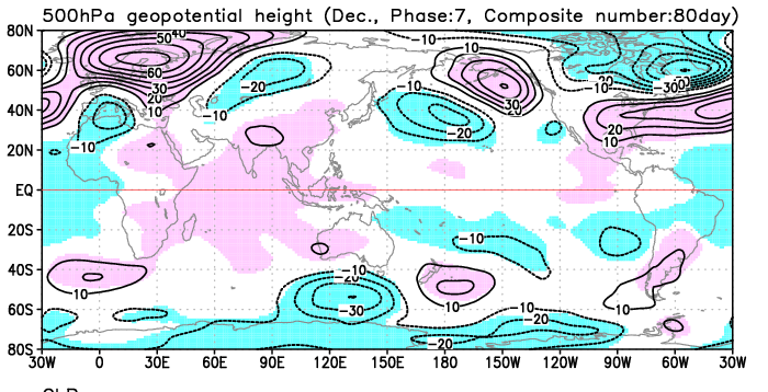
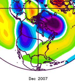
Same page as raindance....when I see phase 7 December composite all I can think of is Dec 2007, although that month didn't spend much time in that phase in a literal sense.
-
We got an early taste for fall in late August into early September before the endless summer pattern arrived in September with backloaded monthly record heat.
-
40 was my low
-

Spooky Season (October Disco Thread)
powderfreak replied to Prismshine Productions's topic in New England
Frozen solid this morning with 5+ hours at or below freezing. 30F. -

Spooky Season (October Disco Thread)
CoastalWx replied to Prismshine Productions's topic in New England
Man what a torch coming up.


