All Activity
- Past hour
-

-
Early confusion
-
I’ll take the rain though.
-
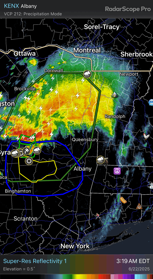
00z 3k nam nailed that diving south into C NY.
-
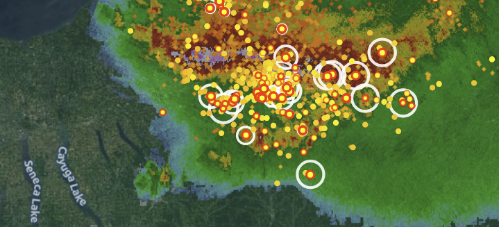
Nice bookend vortices and warm air feed. Its also had a few hail cores throughout its life cycle .


-
Mehsoscale AWT
-
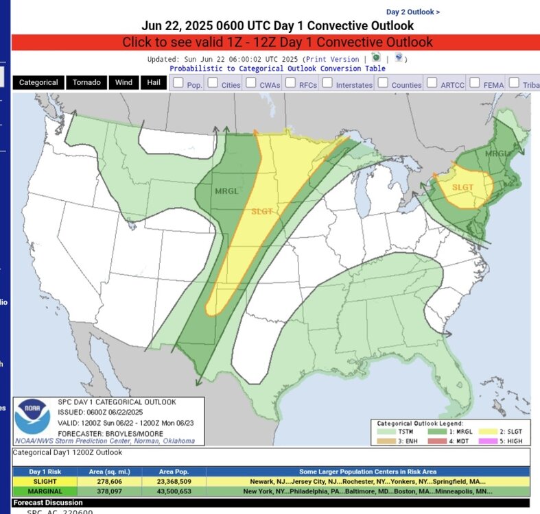
So as it turns out, this is all associated with the thunderstorm complex dropping out of new york, pretty nasty one too with a bookend vortices atm. https://www.spc.noaa.gov/products/outlook/day1otlk.html
- Today
-
threat went south but no shortage of moisture there will be flooding somewhere possibly central midd to leb line (nevermind moving too fast), but nothing like NY nice complex ene of the finger lakes I think thats why we were slight earlier and moved.....man thats some rain and lightning
-
lol no summer thread makes sense I guess because it's dead in summer, but man there is some rain coming tonight, i just feel it
-

2025-2026 ENSO
Stormchaserchuck1 replied to 40/70 Benchmark's topic in Weather Forecasting and Discussion
Strong +NAO this June.. will probably be +1.0-1.5 for the month. All but a few days in the beginning of the month have been positive. Here's how that rolls forward into July.. 2012's arctic ice melt record might be safe for another year -
2025-2026 ENSO
Stormchaserchuck1 replied to 40/70 Benchmark's topic in Weather Forecasting and Discussion
For fun.. I'm going to keep running forward with my Energy play re: a hotter than previously expected Summer taking hold in the eastern US and Europe (I think somewhat related to the Solar flares and +NAO). I've created a complex mathematical algorithm to predict Futures market moves for the next-day based on historical data.. and all the Energies continue to run an Up future projection as per this method (HO, RB, CL). This was as of Friday close (5pm, but I didn't run the numbers until now). It's for Monday and Tuesday, % shown is the average expected move (actually x2 since it's 2 days). Just for fun.. since not much is going on. I've hit on Heating Oil 2/3 days so far with a combined total of +0.8%. The signal carries into next week. It will be my 4th and 5th day with a "play", and watch long range models possibly trend toward a hotter pattern for July. -
Same here. 75 now
-
Long storm around noon to early aft, just avg. On radar there was a segment of the large MCS that looked to be bowing and racing SE towards me. Just as it reached it fell apart fast and I didn't have any unusual wind gusts. In awe that my station put out <4mm - it seemed to be a deluge. WUN had over 20mm expected during it.
-
2025-2026 ENSO
Stormchaserchuck1 replied to 40/70 Benchmark's topic in Weather Forecasting and Discussion
Flipping the WPO could be more difficult though.. this is a very high correlation and a uniform map.. notice how basically the whole N. Hemisphere is above average SSTA's before a +WPO Winter Indian Ocean signal is what I like because it's a West-Pacific index, so that makes sense, as the pattern goes from west to east. It is theorized that Indian Ocean SSTs are decadal also, but they do seem to be running a pretty linear trend up since the early 1900s, we are also now in a positive phase. Summer/Fall monsoon there is usually pretty telling about the following Winter WPO. Believe it or not, NE Russia has had negative Winter temp anomalies since 2018 (+WPO) -
11PM EWR: 85 LGA: 82 (wenr up a degree from 951) NYC: 80 New Brnswck: 79 JFK: 78 (up 6)
-
You guys are gonna get your cold. You are gonna get your snow, too. Starting in 2030. I'll be way too old. But get ready. Buy 50 Jebman Shovels, several snowblowers and get some construction equipment. You're gonnabe charging exorbitant rates for snow removal. You guys are gonna get so damn tired of snow you will move south!
-
We are due. Nor'easters will clobber DCA with heavy snows and Vodka cold, over and over and over again.
-
Yeah what sucks with this pattern is our severe chances…well at least widespread are super low. Only EML we get is tomorrow. If we get anything with the front mid-week…could be some good storms but severe would be more localized. More often than not Big heat doesn’t end with good severe here
-
Watch it be 70s 100s heat and destruction heat 100s 70s the next 4 days. 0 heat wave with severe impact
-
 DCA: 106 IAD: 103 BWI: 102 RIC: 101 I am late but I said what the fook. Hey I am a last minute! I am a last minute! I'll confess WHY I completely forgot about the summer max contest. I am as severely badly head over heels in LOVE, with ancient Egyptology, especially hieroglyphs, now, as I was once in love with jebwalking in the snow and ice and wallowing in stolen drifts at 3 in the morning. Stuff like Gobekli Tepe are now my favorites, but it's the egyptological stuff, the hieroglyphs, cursive hieroglyphs, hieratic, demotic, coptic, and even outright Egyptian Arabic, in fact ANY alphabet not like our own, has become a kind of Indiana Jones-like fascination for me. I have also been literally swept right off my feet by the many Kings and Pharaohs and all the Dynasties and Pyramids, I want to KNOW THEM ALL !! I long to immerse myself in thousands of ancient Egyptian hieroglyphics, just like Daniel Jackson of SG-1 !!! I mean to learn every last archaeologist who ever studied Egyptology, like Howard Carter! This, is why I have totally forgotten the hallowed Summer Max Contest. I absolutely adore all those hieroglyphics. I love to take jebwalks in 105 weather while pretending I am down in Lower Egypt like Howard Carter making epic discoveries and then meticulously cataloguing every last scrap of pottery that even has one tiny cuneiform or hieroglyphic on it! And, I'd make damn sure every last artifact gets transported to the Egyptian Museum in Cairo!
 -
Radar looks like 70s/light rain Sunday wah wah wahhhh
-
George BM, July 1 and a brand spankin new Banter Thread is approaching. PLEASE write us up an EPIC hurricane yarn featuring an epic 270 mph hurricane getting drawn into the mouth of the Chesapeake Bay then going stationary right in the middle of it with Bay water temps in the upper 80s. Lets start this Summer off with a BANG! HUGE rainbands dumping hyper efficient rain rates, Bay of Fundy-like SURGE and epic Banda Aceh-like waves on top of the surge and tons of tornadoes! Widespread 150 year freshwater flooding, whipped into a Katrina-like froth by the banshee winds over the entire Mid Atlantic! Extreme rain tallies in the Appalachians! Entire towns in western Virginia getting swept out onto the Piedmont by extreme floodwaters! If there is any professional forecaster in the National Weather Service who can portray this, it has got to be YOU, George BM!!!
-
Warm night Still in the 80s
-
And I’m in favor of the distance requirement increase. The term derecho should be confined to the top 1% of severe squall lines. And not just in distance but degree and extent of wind damage and (if possible) measured wind gusts.
-
TBH, with the new (well not that new) distance requirement we may never see a derecho again in the Northeast unless it’s something that rips across the upper mid-West and northern Great Lakes, southern Quebec, and then finally our region. It would have to be something ongoing…like what occurred in 1995


.thumb.jpg.6a4895b2a43f87359e4e7d04a6fa0d14.jpg)


