All Activity
- Past hour
-

January 2026 regional war/obs/disco thread
dendrite replied to Baroclinic Zone's topic in New England
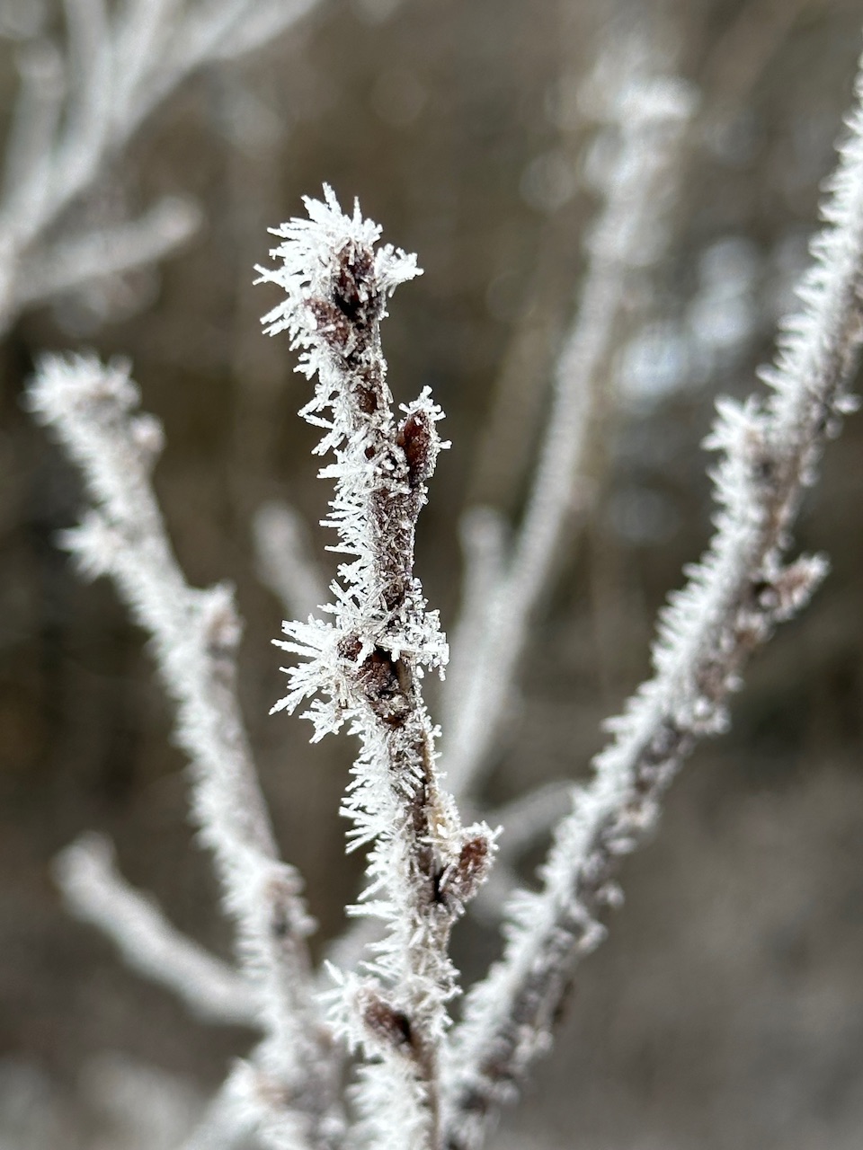
20.5° here There’s some decent rime on the trees (for our standards)
-
Central/west Denver and from south of there did OK. I probably mustered together 2", most of that coming last night.
-

January 2026 regional war/obs/disco thread
40/70 Benchmark replied to Baroclinic Zone's topic in New England
I would bet anyone, any amount of monkey the monkey is long gone by February 1. -
It’s an outlier among all the available guidance.

-
January 2026 regional war/obs/disco thread
40/70 Benchmark replied to Baroclinic Zone's topic in New England
I was a bit surprised it got down to 19.8....figured there would have been a higher launching pad. I'm sure it's mostly fake born of radiational cooling and will be wiped out shortly, but still- -

January 2026 regional war/obs/disco thread
CoastalWx replied to Baroclinic Zone's topic in New England
Exactly. Just frustrating and I paid my dues. Especially frustrating when the cape had 6+ I think at least 2 times since. -

January 2026 regional war/obs/disco thread
dryslot replied to Baroclinic Zone's topic in New England
Yeah, Low was 13.8°F this morning, Its a bit slick out there. -
January 2026 regional war/obs/disco thread
40/70 Benchmark replied to Baroclinic Zone's topic in New England
Combination of cold and low solar irradiance has really maximized snow cover. -
I agree with you and the lo g range looks like warm weather at least here near Dover Delaware. Of course things can change. Beyond the 16th the weather remains in the 30s during the day and upper 20s at night through 21st and start to climb into the 40s 23rd with slight chance of snow showers those days. That's to far into the future and will change. I'm heading to the farm below eagles Mere PA next week for the last weekend of bow hunting. The weather there is even nice with temps day upper 20s and lows middle to upper teens.

-

January 2026 regional war/obs/disco thread
ORH_wxman replied to Baroclinic Zone's topic in New England
Shit snow totals but I’m on like day 33 of snow cover, lol. I don’t think I’ve had more than 4” OTG at any time either. Normally 33 days at this point would mean a great start to the winter with likely multiple warning events, but not this year. As much as I hate brown frozen ground, if we are going to get a decent storm next Friday, then I wouldn’t mind starting clean. -
January 2026 regional war/obs/disco thread
40/70 Benchmark replied to Baroclinic Zone's topic in New England
I think spiking the MJO amplitude in phase 7 later this month would further bolster confidence in this outcome, but my confidence is already pretty high. -
The shrinking Northern Hemisphere cold pool is leading to these Arctic outbreaks covering a smaller geographic region than they used to.
-
January 2026 regional war/obs/disco thread
dryslot replied to Baroclinic Zone's topic in New England
Well that was a short thaw period.
-
January 2026 regional war/obs/disco thread
40/70 Benchmark replied to Baroclinic Zone's topic in New England
Man, no wonder you've both been so cranky...4 years... -
At 7 am it was 43.5/39.3 after hitting 37.6 around 2 am. Amazing the number of times that has happened since Christmas.
-
2025-2026 ENSO
40/70 Benchmark replied to 40/70 Benchmark's topic in Weather Forecasting and Discussion
Absolutely....many on social media, including DT, are always inclined to rush the demise of ENSO. It's tiresome. I do expect the PNA to be the primary catalyst for some significant snowfall here in short order, as I do not expect NE coastal snowfall to remain this paltry. -
January 2026 regional war/obs/disco thread
CoastalWx replied to Baroclinic Zone's topic in New England
I just want this 6” monkey thing off my back. Since Feb 2022. -
January 2026 regional war/obs/disco thread
CoastalWx replied to Baroclinic Zone's topic in New England
Tenor of the season! -
Now the Final Jeopardy question. Will The GFS OP still show this snowstorm in NYC Metro during the 12Z GFS Model run ? At least it is now under 1 week away.........
-
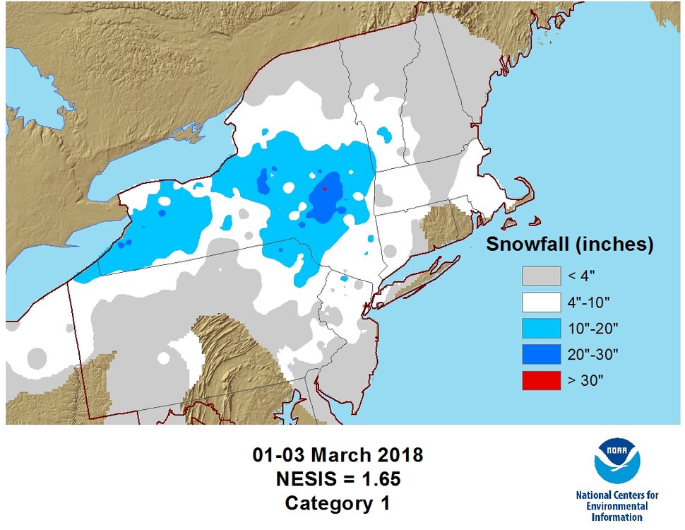
yep thats another one that i always think of, too low again CT/MA and really low for NH/VT Theres definitely some missing ones on that list, theres no way Feb 5th, 2001 or Mar 4-6, 2001 isnt a Cat 1 or 2. I get the formula but there is far lesser events that still scraped the big cities like new york that made that list. This ones gotta be the worst. NYC got zero snow from this. As well as most of CT and all of MA outside the berkshires. So this one is super overdone for tri-state/sne
-
January 2026 regional war/obs/disco thread
40/70 Benchmark replied to Baroclinic Zone's topic in New England
I don't mean "deathblow" to winter...as in winter over; quite the opposite. It's just getting started, as frustrating as it's been. -
Tough to call it full coverage this morning but it's close. Still over 80% cover but it's pretty thin. This dense freezing fog kinda sux
-

2025-2026 ENSO
donsutherland1 replied to 40/70 Benchmark's topic in Weather Forecasting and Discussion
Social media noise about pattern chaos and dramatic shifts in social media videos notwithstanding, I am impressed how drama-free and orderly the pattern progression has been so far this month. The East was supposed to experience a thaw of about a week or so. That's playing out nicely. Afterward, a gradual transition toward colder but not severely cold weather was expected to occur. That's poised to play out. Most of the southern tier with the exception of the Southwest where a well-signaled intrusion of cold is now underway, was expected to stay mild. It has. Going forward, the progression toward cold from the Great Lakes to the Northeast (Mid-Atlantic and New England) remains on course. No significant Arctic outbreaks or snowstorms are likely through mid-month. Afterward, there is potential for the cold pattern to become snowy, but that's where the largest uncertainty rests. If the PNA undergoes a regime change to predominantly positive values near or after mid-month, prospects for East Coast snowstorms would increase. If not, frequent, but smaller snowfalls would be the norm. An WPO-/EPO-/AO- pattern is generally cold regardless of the PNA except in the Southeast (PNA+ is cold). By the end of this weekend, one should have higher confidence in the PNA evolution. Historically, a regime change is favored following the break in long-duration winter PNA- periods. But one cannot rule out a more unusual situation where the PNA only briefly goes positive before returning to its mainly negative state. However, extended range PNA forecasts which have low skill are insufficient. Overall, January still appears on course for a colder than normal outcome from the Great Lakes to New England. The southern tier from the desert southwest across to the Southeast will likely wind up with warm anomalies. Cold shots will still be possible, particularly in the Southeast as the month advances. Finally, with respect to the La Niña, the atmosphere remains well-coupled. The AAM- is powerful proof that things remain coupled. Nevertheless, the La Niña continues to fade, and that process will continue through the winter. Weekly figures could begin to reach values just below La Niña threshold during late January. A significant WWB is possible this month. If it occurs, it would be unusual but not unprecedented. One such WWB occurred during Winter 2016-17. That a WWB might occur won't necessarily mean that February has to be cold. February 2017 wound up being exceptionally warm. I do not expect that scenario this time around. The full range of variables easing influence of ENSO, teleconnections, etc., will determine the February 2026 outcome. -
January 2026 regional war/obs/disco thread
40/70 Benchmark replied to Baroclinic Zone's topic in New England
I mean that that PV is going to ultimately incur a severe disruption that will end in a split, after the stretching of the next few weeks. -

January 2026 regional war/obs/disco thread
Snowcrazed71 replied to Baroclinic Zone's topic in New England
What do you mean with the death-blow in February ( sorry... Not sure if you mean it's gone or it's gonna be a doozy )