All Activity
- Past hour
-
Essentially a "head on" hit. Strong winds and pushing a lot of water out in front of it.
-
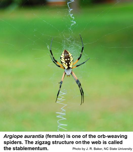
Just guessing but maybe the yellow sac spider. Found in most parts of the world
-
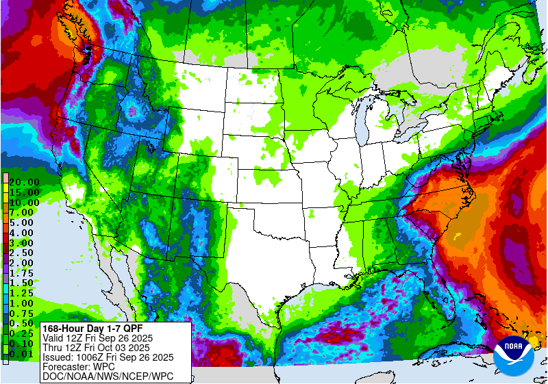
1.41 rain from the event. Much needed at that!
-
Meanwhile, Humberto is likely a major already. It just exploded in intensity.
-
Yup. Some can bite and they all have venom to kill prey for sure but except for the black widow and the brown recluse there are no spiders in this country with the kind of venom to threaten people. And they are very shy spiders in general as well. And neither of them can be found in this part of the country. More the south and Midwest
-
Yup it should be a sin to kill those. They are very useful and pretty to look at
-
When looking at recon earlier I didn't think that we had anything closed, but perhaps that's a function of the possible LLC being so close to the coast that recon can't get there. Looking at some of the surface observations, I guess you can close this off. I suppose the northerly wind on the south Cuban coast implies some sort of LLC. I just think it's marginal at best for now.
-
ASATT All spiders all the time
-
Very intense wind event across the Azores today. Horta gusted well over hurricane force and areas in the mountains saw gusts exceeding 100 knots. Here’s video from Horta this morning https://x.com/infometeotuit/status/1971536347845554336?s=46&t=NyKvXvI1o-sJQb-68mmo4g
-
Invest 94L—80% 2 day and 90% seven day odds of development
RU848789 replied to WxWatcher007's topic in Tropical Headquarters
Greg Postell on TWC was just saying he thought there was enough evidence of a low level closed circulation to name this Imelda and isn't sure why it hasn't been named yet. Personally, given the wildly varying model runs to this point, I wonder if the NHC simply wants a bit more time to issue actual track/intensity forecasts. He also mentioned the conflict between anomalously warm waters ahead of Imelda vs. some very dry air aloft forecast to be in its path, making intensity forecasts very difficult - and we already know the impacts of the closed SE low and Humberto with possible Fujiwhara effects are making the track forecast very difficult. The one thing that seems almost a given is that at least parts of SC/NC/VA, especially near the coast, will get a lot of rain - how far inland that very heavy rain gets and whether we're talking 4-8" of rain (which most can handle) or 10-20" of rain (big flooding) is an open question. -
For sure. On the one hand a stronger Humberto is more likely to keep 94L from moving northward enough to be picked up by the ULL, allowing for an escape route. On the other hand a stronger Humberto is more likely to move more Polward (East) away from 94L, having less influence
-
It’s just in the worst possible place and orientation for our sensible weather here. The warmth is quite strong, reinforcing and our latitude in the largest ocean and weather flowing toward us directly from that place. And we saw that even a strong El Niño couldn’t really nullify it. Really hoping it’s temporary and goes away. If Pensacola FL can still get major snow events so can NYC.
-
Humberto is much stronger than a Cat 1 right now, special advisory should be in order before 5pm
-
Humberto looks to be trending stronger than expected so far, and track is trending more towards Bermuda...if the trends continue, how will this impact the track of the other storm? Interesting to watch it play out...
-
20-21 I’d rate as good to very good here, 21-22 as generally average but good for the eastern 2/3 of LI that was slammed by the Jan blizzard. Islip I think had close to BOS’s snow for the season and 24” in the blizzard. The best of 2020-21 was NYC and west.
-

2025-2026 ENSO
40/70 Benchmark replied to 40/70 Benchmark's topic in Weather Forecasting and Discussion
We probably won't indentify it until we see the whites of the snow. -
Humberto going nuclear. This might be a cat 5 candidate
-
No, it wasn't that. It was yellow (or like a golden brown) with the light orange body or brownish orange. But it was crawling at me...I had no choice.
-
As a Cowboys fan, I approve of this message.
-
Storm total 2.64", almost as much as July/August combined (2.85"). About 1.8" fell 5 PM-midnight. Neither the Sandy nor the Carrabassett have risen much, about 1/2 foot. The upper parts of their watersheds received less rain - 'Bassett 1.14" and Rangeley probably about the same. Sounds like orb weavers. They’re great at killing other bugs. Non venomous to humans I've read that almost all spider species are poisonous - it's how they eat - but very few are dangerously poisonous.
-
- Today
-
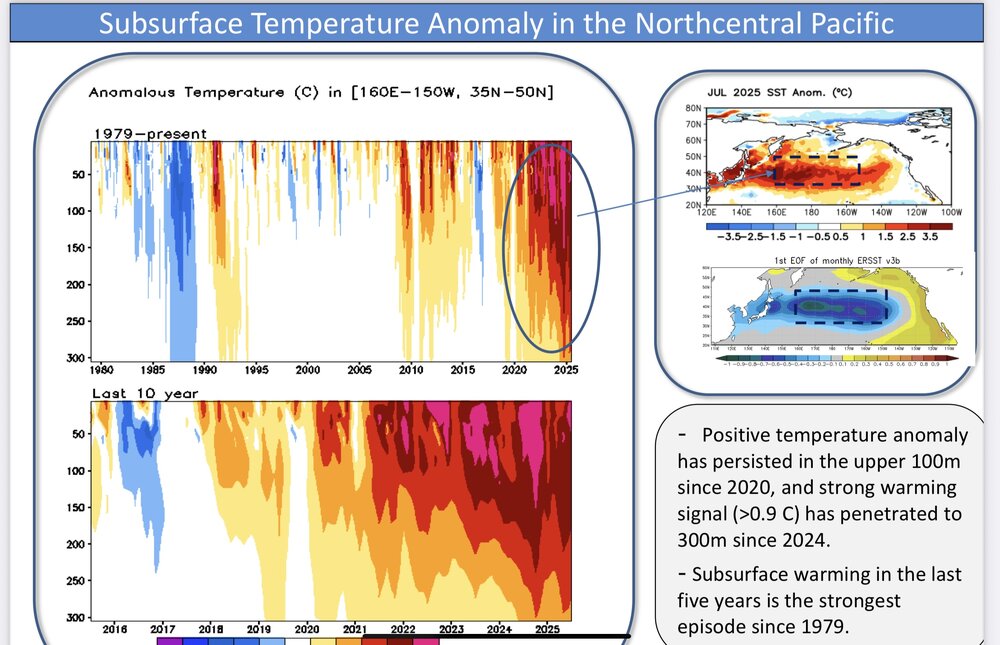
Yeah, those surface SSTs are very impressive. They recently helped to drive the 4 sigma jet streak near the Aleutians when combined with the record cold in Siberia. Just a tremendous thermal gradient. So we are currently getting the big EPO and PNA volatile swings as the shortwaves are racing through the very fast Pacific flow. But they are only the tip of the iceberg since there is so much stored heat below the surface. This deep reservoir of warmth contributed to the record Pacific Jet last winter even though there was the deepest trough in 25 years east of Japan. Past instances of strong troughs east of Japan had much colder SSTs and a much weaker Pacific Jet. But the surface SSTs hardly cooled which maintained the strong SST gradient and faster Pacific flow with the record cold in Siberia. So it gave us the warm storm track through the Great Lakes. Going forward I am trying to find other areas which can offset this dominant climate feature since 2018-2019. But it’s still a work in progress. The last time we were able to push back against this feature was in January 2022. It took the MJO 8 tropical forcing to disrupt the pattern for a month. I will be happy if we can find another competing source of forcing in the coming years to help the snowfall bounce even a little above the 2019 to 2025 record seven year lows. But it may be a challenging task with that massive WPAC heat engine. This cutter, hugger, and suppressed Southern Stream storm track has become very persistent since the 2018-2019 winter when the rapid SST warming took of in the WPAC.
-
The only light I keep on is just outside the back door but its not particularly bright and inside a cove (not sure what its technically called but its an overhang which connects the house with the garage.


