All Activity
- Past hour
-
There are really three key elements of a seasonal forecast. General seasonal temperatures, storm tracks which includes p-types and amounts, and the 500 mb patterns. The Euro missed on the temperatures and 500mb heights. But the storm tracks and snowfall amounts were mostly right. So it just could be that the model stock La Niña forecast only worked out for the storm track through the Eastern Great Lakes. Unfortunately, this has been the default primary storm track since 18-19.
-
3:25PM: I’m getting a thunderstorm now, the first rain here this month.
-
Mostly dry but also normal to below normal temps through mid month. Longwave pattern supports surface HP to our NW/N/NE throughout.
-

2025-2026 ENSO
40/70 Benchmark replied to 40/70 Benchmark's topic in Weather Forecasting and Discussion
Well, that is where we differ. I know in the past I have ostensibly nailed seasons, but always detract from the grade when I'm "right for the wrong reason". Agree to disagree. The forecast was wrong....it just so happen to be correct regarding low snowfall. -
Barry, I don’t know why JB is saying that. The Sept 2025 MJO (first 7 days plus 2 week forecast through 9/21) looks nothing like 2024! Sept 2025: -GEFS: lower to moderate amplitude 2, 3, 2, 1, 8, which is actually favorable -EPS: lower to moderate amplitude 2, 3, 2, 1, 8, which is actually favorable Sept 1-21 of 2024 (blue): moderate to high amplitude 4, 5, 6: like night and day vs 2025 and wasn’t favorable Perhaps JB is looking further ahead to late Sept-Oct. Regardless, he wants lots of clicks!


-

September 2025 OBS-Discussion centered NYC subforum
bluewave replied to wdrag's topic in New York City Metro
Yeah, the one constant is that the warm departures have consistently been more impressive than the cool departures over the years. So when we get these brief cooler patterns, the rebound back to warmer is of a greater magnitude. Whether we just bounce back to mid 80s later in September or see a few warm spots reach 90° again is still unknown.
-
9/7/2015 (see below) was the last 9/7 TWO with no new TCG being considered. However, that was going into a strong El Niño, there was TS Grace then in existence in the E MDR, and the outlooks then went out only 5 rather than 7 days. Also, this TWO failed to see a new TD (which lead to Henri) that formed 9/8-9 in the subtropics: TROPICAL WEATHER OUTLOOK NWS NATIONAL HURRICANE CENTER MIAMI FL 800 AM EDT MON SEP 7 2015 For the North Atlantic...Caribbean Sea and the Gulf of Mexico: The National Hurricane Center is issuing advisories on Tropical Storm Grace, located several hundred miles west-southwest of the Cape Verde Islands. Tropical cyclone formation is not expected during the next 5 days. $$ Forecaster Pasch https://www.nhc.noaa.gov/archive/xgtwo_5day/gtwo_archive.php?current_issuance=201509071437&basin=atlc&fdays=2
-

2025 Atlantic Hurricane Season
BarryStantonGBP replied to BarryStantonGBP's topic in Tropical Headquarters
- Today
-
37 to 48 degrees in nearby areas in Northwest Ohio: Wauseon and Toledo.
-

September 2025 OBS-Discussion centered NYC subforum
donsutherland1 replied to wdrag's topic in New York City Metro
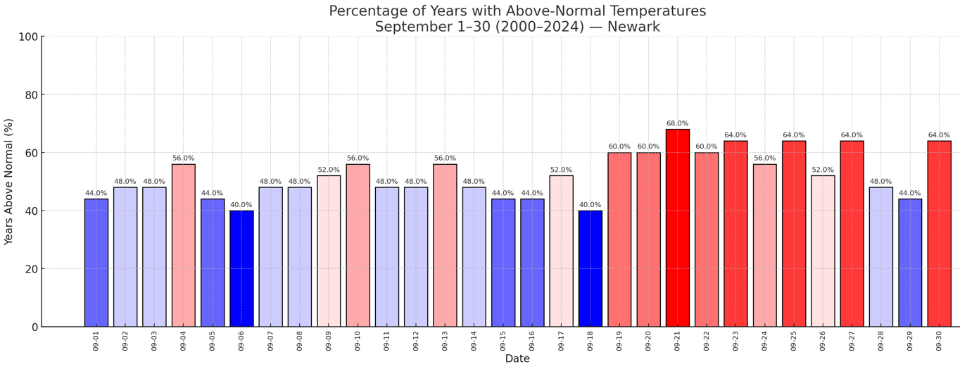
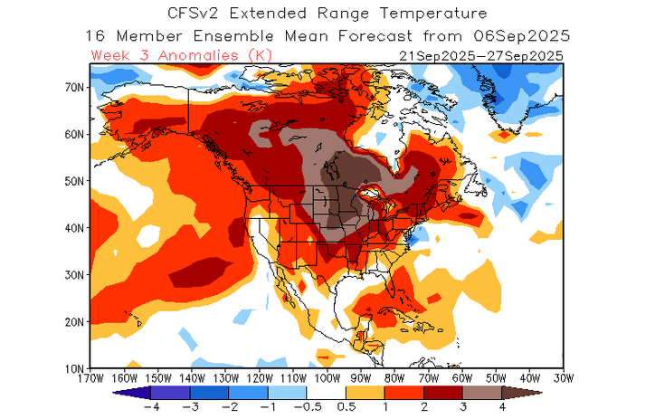
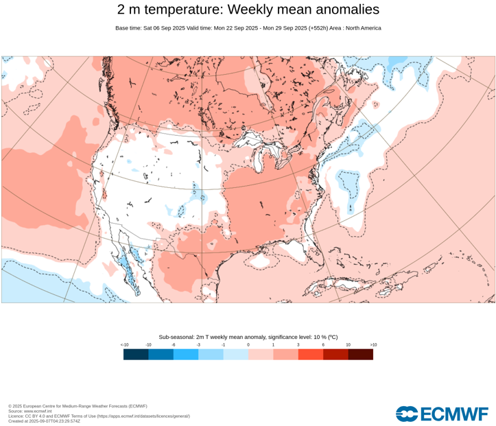
It should also be noted that since 2000, there has been a tendency for Newark's above normal days to be backloaded in September (relative to the 1991-2020 baseline): That doesn't mean that this year will be the case, but the idea that there could be much warmer air in the Plains States/Midwest toward mid-month suggests that it's something to watch for should the guidance continue to show such warmth in the Plains States/Midwest. The Week 3 outlooks on the ECMWF Weeklies and the CFSv2 are warmer than normal in the Northeast: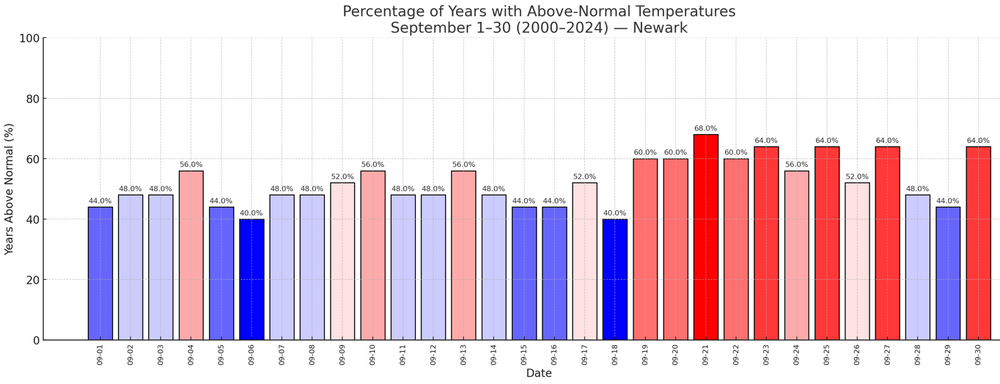
-
September 2025 OBS-Discussion centered NYC subforum
bluewave replied to wdrag's topic in New York City Metro
Nearly 20 other stations in NJ made it to 90° yesterday in addition to Newark. Home News Blog myWxNet Tabular Data Maps Charts Contact Us Data Viewer < BACK 1 DAYFORWARD 1 DAY > Search: City State Eastern Time Source Daily Temp Max Daily Temp Min Daily Dew Point Max Daily Dew Point Min Daily RH Max Daily Min RH Daily BP Max Daily BP Min Daily Precip Daily Wind Max Daily Wind Max Dir ▼ Atlantic City Marina NJ 2025-09-06 SafetyNet 79 71 0.47 32 ▼ Basking Ridge NJ 2025-09-06 Mesonet 86 61 78 61 100 66 30.04 29.88 0.20 15 WNW ▼ Berkeley Twp. NJ 2025-09-06 Mesonet 91 70 75 67 100 56 30.02 29.88 1.15 24 W ▼ Cape May Court House NJ 2025-09-06 Mesonet 88 71 76 69 100 64 0.29 16 SSW ▼ Cedar Bridge NJ 2025-09-06 USFS 89 64 72 60 98 54 1.51 36 W ▼ Charlotteburg NJ 2025-09-06 Mesonet 82 62 78 60 100 72 30.02 29.88 0.39 15 N ▼ Cherry Hill NJ 2025-09-06 Mesonet 89 68 78 66 100 54 0.25 14 SE ▼ Chester Borough NJ 2025-09-06 Mesonet 79 61 72 58 97 67 30.05 29.91 0.05 21 NW ▼ Columbus NJ 2025-09-06 Mesonet 88 66 77 66 99 58 30.00 29.87 0.70 23 SW ▼ Cream Ridge NJ 2025-09-06 Mesonet 91 69 78 67 100 56 29.99 29.84 0.82 21 S ▼ Dennis Twp. NJ 2025-09-06 Mesonet 87 70 76 68 100 64 1.25 21 NW ▼ East Brunswick NJ 2025-09-06 Mesonet 90 67 75 65 96 56 30.04 29.88 0.72 38 W ▼ Egg Harbor Twp. NJ 2025-09-06 Mesonet 87 71 75 69 100 65 30.01 29.88 0.83 17 S ▼ Fort Dix NJ 2025-09-06 USFS 91 70 74 66 98 46 1.73 25 SSE ▼ Fortescue NJ 2025-09-06 Mesonet 82 71 80 71 100 92 30.03 29.87 0.84 41 NW ▼ Greenwich NJ 2025-09-06 Mesonet 88 70 79 68 100 67 2.60 21 W ▼ Hackettstown NJ 2025-09-06 SafetyNet 85 59 30.04 29.89 0.40 15 ▼ Hamilton NJ 2025-09-06 Mesonet 90 67 75 66 99 51 1.08 14 W ▼ Hammonton NJ 2025-09-06 Mesonet 92 69 74 67 100 52 1.47 23 NW ▼ Harvey Cedars NJ 2025-09-06 SafetyNet 79 71 0.84 29 ▼ Haworth NJ 2025-09-06 Mesonet 0.28 24 NW ▼ High Point NJ 2025-09-06 Mesonet 78 59 71 56 99 71 30.03 29.90 0.02 17 WNW ▼ High Point Monument NJ 2025-09-06 Mesonet 74 57 70 55 100 77 0.01 27 WSW ▼ Hillsborough-Duke NJ 2025-09-06 Mesonet 88 62 76 62 100 63 0.53 26 SW ▼ Holmdel NJ 2025-09-06 Mesonet 90 66 75 66 100 56 1.09 16 ESE ▼ Hopewell Twp. NJ 2025-09-06 Mesonet 89 62 76 62 100 58 30.02 29.87 0.22 31 N ▼ Howell NJ 2025-09-06 Mesonet 91 65 75 65 100 55 30.04 29.89 3.01 15 W ▼ Jersey City NJ 2025-09-06 Mesonet 87 66 76 64 99 60 29.98 29.80 0.66 25 W ▼ Kingwood NJ 2025-09-06 SafetyNet 83 63 30.02 29.88 0.07 12 ▼ Little Egg Harbor Twp. NJ 2025-09-06 Mesonet 100 72 30.02 0.57 31 SW ▼ Little Falls NJ 2025-09-06 Mesonet 86 65 74 59 100 62 30.04 29.88 0.05 16 ENE ▼ Logan Twp. NJ 2025-09-06 Mesonet 89 69 75 64 93 60 30.03 29.87 0.06 18 SW ▼ Lower Alloways Creek NJ 2025-09-06 Mesonet 92 69 79 67 100 60 30.01 29.85 0.38 26 N ▼ Lyndhurst NJ 2025-09-06 Mesonet 86 67 74 62 90 63 30.03 29.83 0.48 34 SSW ▼ Mannington Twp. NJ 2025-09-06 Mesonet 89 69 81 67 100 62 30.01 29.86 0.37 19 SW ▼ Mansfield NJ 2025-09-06 Mesonet 89 68 75 67 100 58 0.83 26 NW ▼ Moorestown NJ 2025-09-06 Mesonet 87 67 77 67 100 64 30.01 29.87 1.00 25 SSW ▼ Mullica Twp. NJ 2025-09-06 SafetyNet 89 68 0.87 ▼ New Brunswick NJ 2025-09-06 Mesonet 89 66 75 65 99 52 30.02 29.85 0.66 42 SSW ▼ North Haledon NJ 2025-09-06 Mesonet 85 65 75 61 99 64 30.04 29.89 0.22 17 SE ▼ Oceanport NJ 2025-09-06 Mesonet 86 66 76 66 100 69 3.06 26 NNW ▼ Oswego Lake NJ 2025-09-06 Mesonet 91 67 76 66 100 59 29.98 29.84 1.62 21 S ▼ Parsippany NJ 2025-09-06 SafetyNet 81 64 0.69 ▼ Pennsauken NJ 2025-09-06 Mesonet 91 70 73 66 92 55 30.03 29.87 0.12 24 WSW ▼ Pequest NJ 2025-09-06 Mesonet 82 61 76 61 100 64 30.04 29.86 0.43 16 W ▼ Piney Hollow NJ 2025-09-06 Mesonet 92 69 75 67 100 57 1.88 18 NNW ▼ Pittstown NJ 2025-09-06 Mesonet 82 63 73 60 95 59 30.04 29.91 18 W ▼ Point Pleasant NJ 2025-09-06 SafetyNet 83 68 0.73 19 ▼ Ramsey NJ 2025-09-06 SafetyNet 83 62 29.99 29.83 0.06 13 ▼ Red Lion NJ 2025-09-06 SafetyNet 91 68 ▼ Sandyston NJ 2025-09-06 Mesonet 81 60 72 57 100 67 30.02 29.88 0.02 14 W ▼ Sea Girt NJ 2025-09-06 Mesonet 82 68 75 68 100 76 30.03 29.89 0.86 28 S ▼ Seaside Heights NJ 2025-09-06 SafetyNet 73 70 0.42 8 ▼ Sewell NJ 2025-09-06 Mesonet 88 70 76 68 100 59 0.60 15 SSW ▼ Sicklerville NJ 2025-09-06 Mesonet 93 70 77 67 100 53 29.98 29.85 1.48 17 SW ▼ Silas Little NJ 2025-09-06 USFS 91 68 73 65 98 46 2.12 22 S ▼ South Harrison NJ 2025-09-06 Mesonet 88 68 77 67 99 63 0.26 16 NW ▼ Stewartsville NJ 2025-09-06 SafetyNet 83 62 30.04 29.89 0.04 20 ▼ Toms River NJ 2025-09-06 Mesonet 90 71 73 66 99 52 0.62 22 SSW ▼ Upper Deerfield NJ 2025-09-06 Mesonet 89 70 78 68 100 64 30.01 29.88 2.62 29 W ▼ Vernon Twp. NJ 2025-09-06 SafetyNet 78 58 100 71 0.02 20 ▼ Vineland NJ 2025-09-06 Mesonet 90 70 80 69 100 60 30.01 1.63 22 NW ▼ Wall Twp. NJ 2025-09-06 Mesonet 86 67 76 67 100 67 0.98 17 SW ▼ Walpack NJ 2025-09-06 Mesonet 82 57 72 56 99 65 30.05 29.92 0.01 14 N ▼ Wantage NJ 2025-09-06 SafetyNet 77 60 94 67 30.03 29.88 0.03 23 ▼ West Cape May NJ 2025-09-06 Mesonet 81 68 79 68 100 88 0.01 17 NNW ▼ West Deptford NJ 2025-09-06 Mesonet 90 70 76 64 98 56 30.03 29.87 0.15 15 S ▼ Woodbine NJ 2025-09-06 Mesonet 89 70 78 68 100 59 30.01 29.85 0.99 20 S ▼ Woodland Twp. NJ 2025-09-06 Mesonet 90 67 75 66 100 58 2.22 30 -

September 2025 OBS-Discussion centered NYC subforum
uofmiami replied to wdrag's topic in New York City Metro
1.37” in Syosset & 1.14” in Muttontown for rainfall totals. -
Right around 2” now
-

September 2025 OBS-Discussion centered NYC subforum
Sundog replied to wdrag's topic in New York City Metro
You two aren't really far apart in this conversation. 90 degrees was only achieved at two stations, one of them well to our SW and out of our CWA. All others were mid to upper 80s. But it also doesn't take that much more to go from 88 to 90 in some hot spots. -

September 2025 OBS-Discussion centered NYC subforum
Intensewind002 replied to wdrag's topic in New York City Metro
Final rainfall total was 1.30" for me in Lindenhurst -
September 2025 OBS-Discussion centered NYC subforum
bluewave replied to wdrag's topic in New York City Metro
What model guidance from a few weeks ago suggested that the WAR would flex enough for the 90° warmth yesterday? All the models had a trough in the East for the whole first week of September. This is why I was pointing out a few weeks ago that it wouldn’t take much to sneak in another 90° day when none of the models were showing it. Plus statistically we haven’t had 2 years in a row at Newark not reach 90 after August 17th in over 20 years. This week looks cooler and drier as Canadian high pressure dominates. So if the models are similarly underestimating the ridging in the East later in September on today’s runs, then Newark could make it to 40 days reaching 90° with strong warmth building to our west. I am pretty sure we see more mid to upper 80s like you mentioned. But have included the possibility of another 90° although still to early to know for sure. There is another factor at play. Cooler periods like we have seen since late August have been few and far between in recent years. When they have occurred the warm ups following them have been more impressive. This could mean a higher number of late season 80° days like last year since we don’t always get 90° heat past early to mid September.

-
https://x.com/AndyHazelton/status/1964683857149493603
-

September 2025 OBS-Discussion centered NYC subforum
doncat replied to wdrag's topic in New York City Metro
1.30" rain here since yesterday and 1.68" since Thursday.... a cool 65° currently. -

E PA/NJ/DE Autumn 2025 Obs/Discussion
Hurricane Agnes replied to PhiEaglesfan712's topic in Philadelphia Region
And it looks like the front has moved the band to coastal NJ and it's starting to clear here, with the sun trying to pop in and out. The rain gods gave me an extended, much needed soaking, with nothing over around 0.5"/hr. Ended up with 0.87" in the bucket for today, so along with the 0.01" just before midnight, I have a 2-day event total of 0.88". Currently 68 and clearing, with dp 63. -

September 2025 OBS-Discussion centered NYC subforum
anthonymm replied to wdrag's topic in New York City Metro
What model guidance is suggesting the ridge moves east? -
September 2025 OBS-Discussion centered NYC subforum
bluewave replied to wdrag's topic in New York City Metro
The source region to our west will really be warming up by next weekend. Remember the models missed the 90° heat yesterday from the 6-10 and 11-15 day forecasts. This is what I was discussing back in late August when no 90° days were showing up. So if we can get one of the big highs over Southeast Canada to drop down to the Carolinas, then the usual warm spots like Newark could make it to 40 days reaching 90° if the winds turn more SW. -

E PA/NJ/DE Autumn 2025 Obs/Discussion
Birds~69 replied to PhiEaglesfan712's topic in Philadelphia Region
I was going to guess 1 - 1.25" but it was probably more your amount... . -
E PA/NJ/DE Autumn 2025 Obs/Discussion
Birds~69 replied to PhiEaglesfan712's topic in Philadelphia Region
Besides some initial downpours yesterday afternoon it's been light to semi mod rain off and on. And no thunder boomers...C-. Sun is out... -

E PA/NJ/DE Autumn 2025 Obs/Discussion
MGorse replied to PhiEaglesfan712's topic in Philadelphia Region
0.82” total here. Currently 66F. -
September 2025 OBS-Discussion centered NYC subforum
anthonymm replied to wdrag's topic in New York City Metro
Seriously doubt. Next 10 days at least will be normal to below normal, and by the time late september/early october arrives, climo works against 90 really really hard. Mid to upper 80s not out of the question last week or so of September though.