All Activity
- Past hour
-

Occasional Thoughts on Climate Change
donsutherland1 replied to donsutherland1's topic in Climate Change
He's flailing in a desperate attempt hold onto an unsustainable explanation. First, he claimed that it was an earthquake, even hours after the USGS revealed that the glacial collapse and debris flow triggered the shaking. Then it was past earthquakes that led to destabilization. Now he spins the latest development hoping to evade any climate links, but only exposing his lack of knowledge of both climate and geological processes. As noted yesterday, frost-wedging can lead to a fracturing, disintegration, and breaking of rock over time. Water finds its way into cracks and microfissures and expands as it freezes. The ice then melts when temperatures warm. This repeated cycle eventually causes larger cracks to develop and, ultimately, the rock to split or break. The warming climate in the high alpine regions of the Himalayas has accelerated this form of rock weathering. Finally, notice that he didn't provide a link to the actual story. He wanted to limit his audience to his opinion, depriving them of the full contents. Here's why: the story goes on to state: Mountain geographer Alton Byers of the University of Colorado Boulder has linked the disaster to climate change. He said permafrost, which has helped hold together high-altitude rock, ice, soil and glaciers for thousands of years, is weakening and becoming increasingly unstable. However, Cook and Shugar have not established a direct link between global warming and the bedrock failure. While they believe permafrost is melting and may be contributing to the destabilisaton of mountain slopes, they said further analysis is needed to determine the precise cause of the collapse. In sum, the article he references to dismiss any link to climate change actually does not rule out the role of climate change. -
The southern semicircle of the circulation continues to improve. However, the NE quadrant has simultaneously deteriorated on radar. I'm doubting we're going to see any significant intensification prior to landfall at this point, though there is still time for some further pressure fall and marginal increase in winds. A moderate 50-55 kt TS still seems quite possible, but a borderline hurricane would be surprising at this point. We would need to see nascent eyewall or core band developing, and that doesn't seem to be occurring. We've got, what, six hours remaining, give or take an hour?
-
The CanSIPS monthly model run recently came out for September and it is still indicating lower heights generally in December thru March centering generally in lower Mississippi valley-----extending east. What is interesting is the last 3 runs or so have lowered heights some in the same general area. What that means at this point? Hard to say, but if you also look at precip for same period, it continues to show a possible active storm track, which includes the Carolinas.
.thumb.gif.00cdf1b35670b2f9927d23bccabe1a32.gif)
-
Exactly! And it is why my posts have been they way they have been since last night. Not being a negative Nancy, just see thing for what they are. The signs of RI are just not there, and those signs are not subtle (data rich area Edouard is in, so higher confidence what exactly is going on w/ the storm over time). And you see what recon just found, despite sat looking better, and radar looking *much* better. If you just showed me a radar of Edouard now in a vacuum, I would say, "that's probably a strong TS or min HU w/ that kind of banding and a partial eyewall!" And yet NHC just stays the course on the 12z update stating RI is imminent. Sometimes they prioritize consistent messaging over what is actually happening evolving in real time, just not to confuse the public. I can get that, but it really not being 100% truthful IMHO, and we all see the same data, so there are going to be some that call NHC out unprofessionally on social media for clicks and likes, among other things. So that's the flip side of not changing messaging as the event evolves -- it invokes criticism that in this case is legit. Even when it is not legit, that still presents challenges on a PR and overall perception level.
-

Septorcher 2026 Discussion - Endless Summer
Damage In Tolland replied to Damage In Tolland's topic in New England
Yup. We don’t want any of your winter rain bands here. Keep em -
 top-rated online pharmacies: no rx needed pharmacy and shop medicine online
 -

Septorcher 2026 Discussion - Endless Summer
CoastalWx replied to Damage In Tolland's topic in New England
Man hope to god every band this winter stalls in a N-S fashion over the RI/CT border. Suck cirrus. -
Septorcher 2026 Discussion - Endless Summer
CoastalWx replied to Damage In Tolland's topic in New England
I like them because it has some good model content. It’s like deleting history. -
We made it! Happy start to Meteorological Fall, yall.
-
Septorcher 2026 Discussion - Endless Summer
Damage In Tolland replied to Damage In Tolland's topic in New England
Just delete your attachments. I just did -

Septorcher 2026 Discussion - Endless Summer
SouthCoastMA replied to Damage In Tolland's topic in New England
That radar screams .05-.10" if I'm lucky -
mexican mail order pharmacy: MexiPh - online pharmacy in mexico
-

Septorcher 2026 Discussion - Endless Summer
dendrite replied to Damage In Tolland's topic in New England

-
LMAO it’s true, this thing would likely be significantly less impactful than some of the Ohio valley derechos we’ve seen this summer even if it became a hurricane
-
Here’s Martz’s follow-up 5 minute video, which incorporates the “massive bedrock collapse” beneath the glacier as opposed to glacier collapsing, itself, theory that he quoted in his prior post, which I just posted two posts above this: @donsutherland1@chubbs
-

2026-2027 Record-breaking El Nino
40/70 Benchmark replied to Stormchaserchuck1's topic in Weather Forecasting and Discussion
CANSIPS def. has that Canadian ridge too far NW....I'm sure of it. Most of my composites have it just NNW of the lakes. -
After the Rockies series, the Boston/Cleveland/Toronto stretch will determine the season. 6-4 through that at worse I think is what the O's can afford.
-
 Mar Lago of course...
 -
Septorcher 2026 Discussion - Endless Summer
CoastalWx replied to Damage In Tolland's topic in New England
Ad soon as dendrite gives me more storage. -
Monday, August 31 - Thursday, September 3, 2026 Convective Episodes
CoastalWx replied to weatherwiz's topic in New England
Del Boca Vista? -
2026-2027 Record-breaking El Nino
40/70 Benchmark replied to Stormchaserchuck1's topic in Weather Forecasting and Discussion
Absolute same page. -
Nice to see the o’s finally take some momentum against weaker opponents. But if they do make the playoffs, they will have earned it. Nowhere to really hide in their September schedule.
-
2026-2027 Record-breaking El Nino
40/70 Benchmark replied to Stormchaserchuck1's topic in Weather Forecasting and Discussion
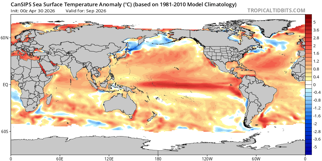
August Run: September Run: -

2026-2027 Record-breaking El Nino
bluewave replied to Stormchaserchuck1's topic in Weather Forecasting and Discussion
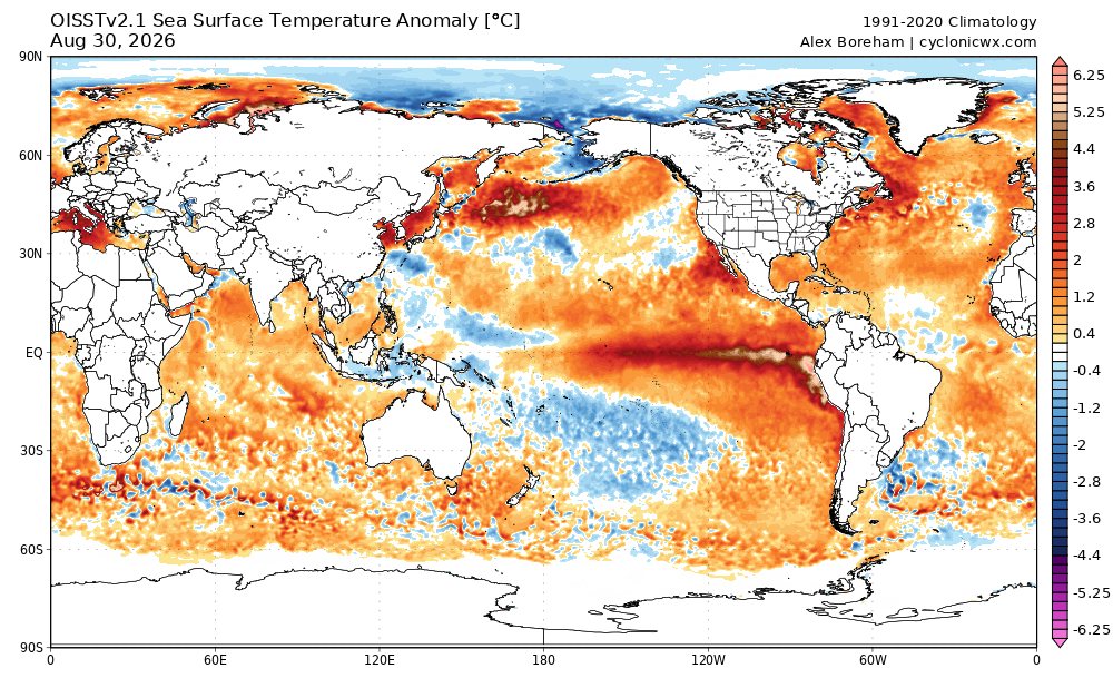
The CanSIPS completely missed how east based this event has become and is just repeating the same error in its current forecast. Most other models also showed this but not to the same degree. It also underestimated the record warm pool east of Japan so I would take forecasts in that area with a pinch of salt also.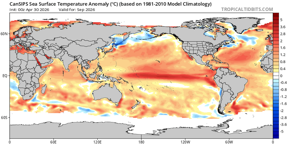
-
You shouldn't be!..they are still trying to determine if next Monday is Memorial Day or Labor Day..


.gif.7a7b85cc515d29bfd005410f62eeccec.gif)