All Activity
- Past hour
-
I bet you never get to say after a snowfall that your grass is covered.
-
5 days ago
-
My official forecasted high tomorrow is 55. I was 5 degrees above my forecast high today so saying we’ll be between 55-60 tomrrow isn’t a big stretch. And the point remains the same. After a 55/57/60 degree day on Saturday, you’re not going to see accumulation with .10 QPF the next day in March.
-
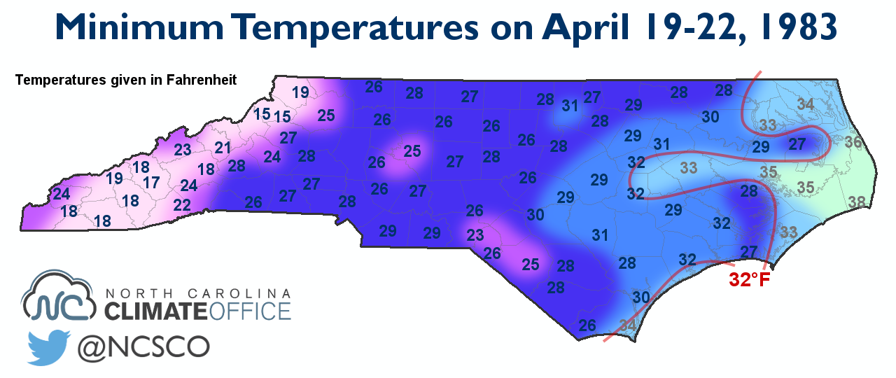
April 1983 takes the cake when it comes to hard freezes: It snowed in places like Philly and NYC during the 19th and 20th.

-

2025-2026 ENSO
40/70 Benchmark replied to 40/70 Benchmark's topic in Weather Forecasting and Discussion
https://easternmassweather.blogspot.com/2026/02/latter-january-early-february-display.html -
feb2010.pdf
-
2025-2026 ENSO
40/70 Benchmark replied to 40/70 Benchmark's topic in Weather Forecasting and Discussion
Hey, I'd still rather it split for verification purposes...better a few weeks late than never. -
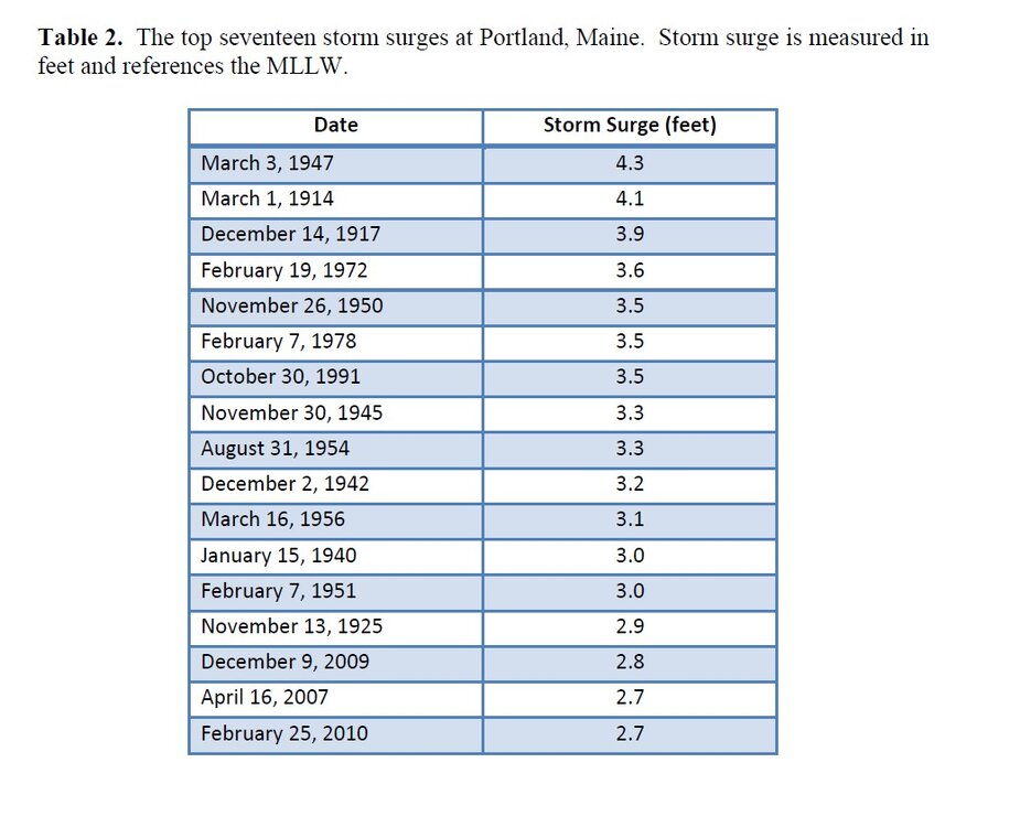
Gust 91 mph IOSN3 and 94 mph Seabrook. "Double" high tide at BOS on the gauge and it was fortunate the the storm tide did not coincide w/ high tide. It was so flipped/wrapped up, NYC got 20" snow on a NW. 7"+ rain total in SW ME which is an enormous rain total for a single storm in the winter month NEUS. The CAA pattern was whacked w/ temps dropping sharply on the S Coast as winds shifted to the S! CoastalWx liked the snow squalls all over the place for two days after the above as the upper low stalled right over the region! I thought t was as Shapiro-Keyser cyclone (T-bone frontal fracture), which are rare in the NEUS, but I came across the paper recent and it was some weird hybrid thingee! I attached the paper from GYX. Look at the sfc analyses in the paper for the evolution of the sfc low. Went from N-S to W-E axis in short order ("instant occlusion"). Also, on the last page, a list of the top 17 storm surges at PWM. I thought the Bliz of 78 was PWM's highest, but 4 exceeded it and 2 others tied it. ta2013-03.pdf
-
I need 3 for 50. Hopefully mid to late march. I will take a grass event.
-

E PA/NJ/DE Winter 2025-26 Obs/Discussion
LVblizzard replied to LVblizzard's topic in Philadelphia Region
0z mesos are way less amped with Sunday’s little wave which makes it cold enough for snow down to I-78. Gonna be interesting to see if that trend continues. -
Epic I just hope we get one good March warning event and push me over 60
-
Gfs is also south and weaker. Wish this was non existent to have Mondays wave track better.
-

Winter 2025-26 Medium/Long Range Discussion
michsnowfreak replied to michsnowfreak's topic in Lakes/Ohio Valley
There's no need to shut it down. If theres nothing to discuss, then no need to post. But snow potential is nowhere near finished. -
Winter 2025-26 Medium/Long Range Discussion
michsnowfreak replied to michsnowfreak's topic in Lakes/Ohio Valley
World of difference in the type of winter it was between western and eastern sub this winter. Though I do have to correct McHenry, chicagos winter will not end up warmer than avg. -
-

2025-2026 ENSO
TheClimateChanger replied to 40/70 Benchmark's topic in Weather Forecasting and Discussion
-
This wave is trending south but weaker on everything.
-
Aerial video of Mt. Mansfield:
-
Okx and box have virtually nothing T-0.5
-

Outta gas and Outta Time: Early March Winter Storm finale
Chris78 replied to Ji's topic in Mid Atlantic
Rgem gets us again with snow changing to a wintry mix.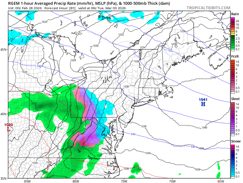
- Today
-
Icon is non existent with this wave.
-

Outta gas and Outta Time: Early March Winter Storm finale
Ruin replied to Ji's topic in Mid Atlantic
No I hate that big of a warm up from 40s or 50 to 70s. we have all spring to hit 70s, 50s is fine for march april is fin for 60s -
I still like 1-3” statewide but timing shifting to the afternoon may hurt that.
-
I think the fx is roughly the same as the last one, I just have lower confidence and added marginal temps in SCT makes it harder
-
Maybe an inch on Sunday. 0z Nam shows that.