All Activity
- Past hour
-

2025-2026 ENSO
40/70 Benchmark replied to 40/70 Benchmark's topic in Weather Forecasting and Discussion
Great baseball analogy, a sport in which analytics has become an increasingly large component of the game....analystics would argue that this will eventually regress to the mean. Our batting average was well above our expected batting average last decade and this decade that is reversing, hence the regression. Now, I understand the valid arguments that this is more than simple regression and while that may be true, it is gong to take some time to know for certain. Each of those 4 season were -WPO, except for 2017-2018, which was carried by the huge March and epic NAO blocking....again, no argument from me that the +WPO attributabed PAC jet is a problem right now. -
And this is why I am happy to be where I am. Currently 57.7/55.9 at 8:30 am. Looking around at temps in the area, 57 at the lake (Moomaw), 57 in Covington, 54 at White Sulphur Springs. Then 68 in Roanoke, 64 in Blacksburg, 66 in Staunton, 72 in C'ville, 77 in Richmond 73 at DCA and IAD. I'll likely warm up to within 5 degrees of the highs east but the cool nights and mornings are glorious.
-
Good morning Liberty. I can appreciate your passion. You’re obviously well stocked between the ears. Perhaps it might be best if you took a dispassionate pause before making some statements. Stay well, as always ….
-
The disappointing part is that most to all of the La Niña +PNA mismatch December into January seasons like 20-21, 17-18, 00-01, and 95-96 were great to amazing snowfall seasons. This past season singularly was extremely low for snowfall compared to past events. This is why the mismatch potential I was discussing back last October with the early MJO indicator had caveats. As other features weren’t lining up like those great seasons. So while I was anticipating the +PNA, the Pacific Jet showed that it wasn’t going to relax right out of the gate in December. So it’s a bit like a baseball game where the team keeps leaving the bases loaded and can’t drive in any of the runs.
-
2025-2026 ENSO
40/70 Benchmark replied to 40/70 Benchmark's topic in Weather Forecasting and Discussion
I think its also important to note that were in an incredibly extreme -PDO regime for a few years and will take time to reverse that....I am sure there will be some initial resistance, but the PDO has come up to coincide with those initial hints of change last season. The baseline assumption regarding these cycles and circulations is preedicated on what has happened in the past....while we can make suggestions as to how that may be changing, it will take time to prove that one way or another. -
Curious to see what heat can be recorded before retreat, if phase 3 arrives in the extended.
-
Seattle was like that too but a lot of them were near the water. Som of them get quite creative building a tarp shelter.
-
2025-2026 ENSO
40/70 Benchmark replied to 40/70 Benchmark's topic in Weather Forecasting and Discussion
I'm sure there have been failed attempts in the past, too...I don't care to sort through dailies for 4 hours, but if you do, then be my guest. Bottom line is that it didn't actually shift, nor is it expected to do so for several more years. Off the top of my head, though I'm sure you will examine the dailies and find some inconsistency...but February 2000 featured an uncharacteristically +PNA during a La Nina, and then of course we had the 2000-2001 season that must have had everyone convinced that the Pacific had flipped....yet 2001-2002 happened. Bottom line is we need to see where we are in the early 2030s. -
foggy with lots of homeless people in tents on the sidewalks?
-
I know how to cool the north atlantic much sooner than that. Melt all the polar ice and that will cool down the waters with the influx of ice water into the north atlantic. That will probably happen within the next few decades too.
-
This past winter was trying to put together the semblance of a +PDO 500mb pattern in the means especially from December into January. But the Northern Stream of the Pacific Jet kept interfering by lowering heights out West as soon as they built. So the -EPO that we usually see with +PDO atmospheric patterns was too back and forth instead of staying as negative as 13-14 and 14-15 did with the great -WPOs we enjoyed back then as you mentioned. Plus the storm track was pure La Niña through the Great Lakes. This could have been a great winter for Eastern snows if the WPAC and Jet stream influence was more muted.
-
A lot of east winds on the weekend especially in southern sections. Similar weather to last Sunday, it appears. Winners north/east, losers south. I’ll take the San Francisco vibe up here on the coast. Love it.
-
go enjoy that new boat some more especially now that you can get out during the week
-
2025-2026 ENSO
40/70 Benchmark replied to 40/70 Benchmark's topic in Weather Forecasting and Discussion
It also took several years for the PDO to shift follwing the strong EL Nino of 1972-1973, so that make sense. -
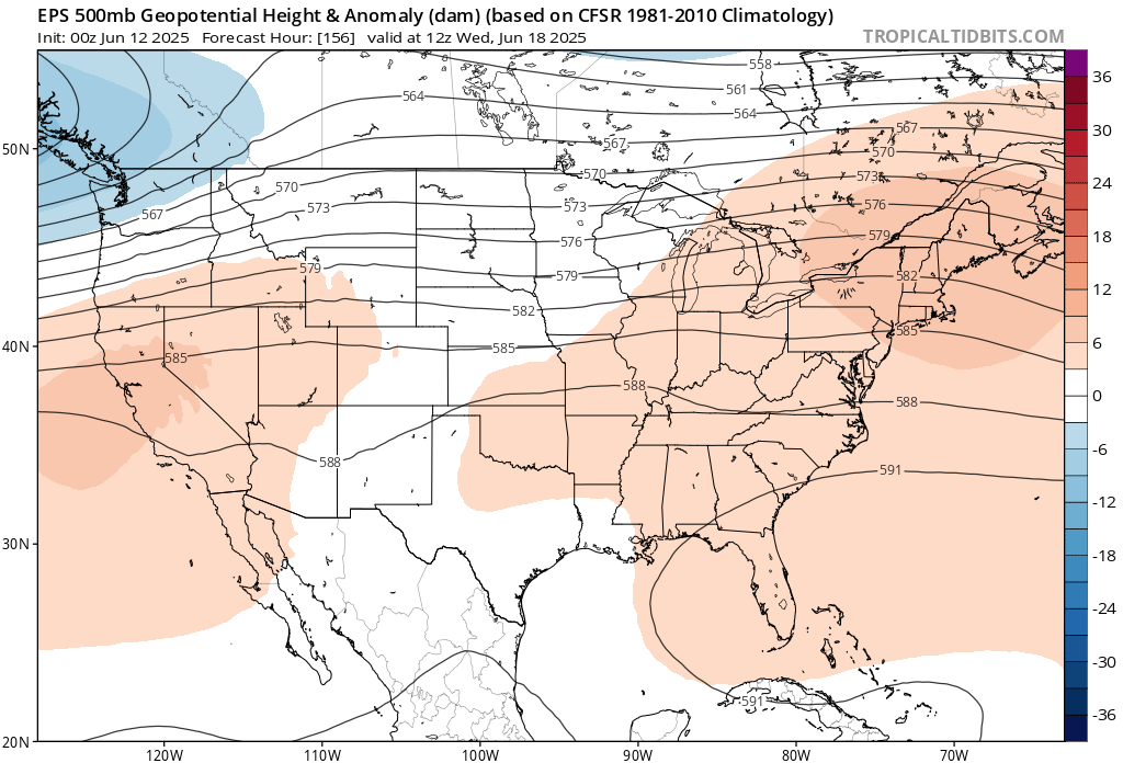
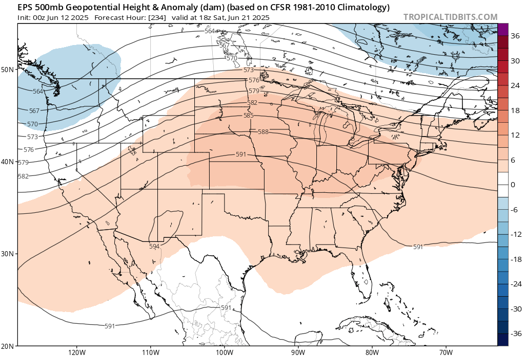
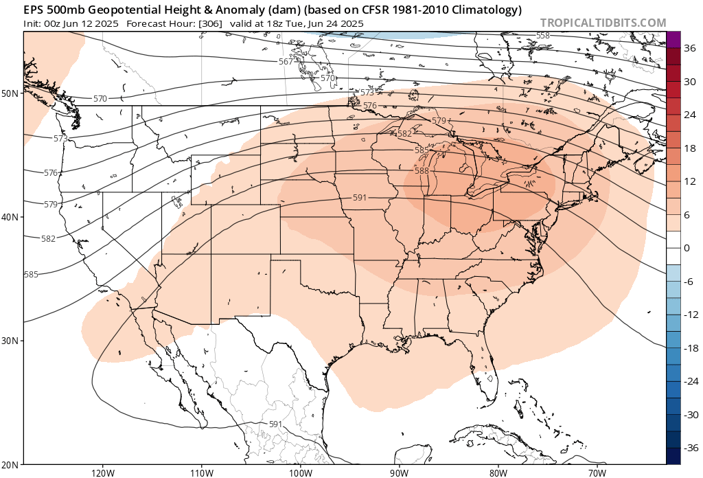
Perhaps we could see our first 95° readings of the season in late June if the WAR and ridge out West link up. But the wild card will probably be if we can get a break in this wet pattern. If it stays too wet, then we could only top out in the low 90s. But a few days of full sun and drier conditions could easily result in mid 90s or higher at the usual warm spots. Especially with the drought out West into Canada. Ridges trying to link up in late June


-
Heaviest rains now forecasted south into the MD/VA area this is majority Sat - Mon;
-
Records: Highs: EWR: 97 (2017) NYC: 93 (2017) LGA: 96 (2017) JFK: 92 (2017) Lows: EWR: 47 (1951) NYC: 48 (1979) LGA: 49 (1979) JFK: 49 (1980) Historical: 1881 - Severe thunderstorms spawned more than half a dozen tornadoes in the Lower Missouri Valley. Five of the tornadoes touched down near Saint Joseph MO. In south central Kansas a tornado nearly wiped out the town of Floral. Hail and high winds struck Iowa and southern Minnesota. In Minnesota, Blue Earth City reported five inches of rain in one hour. (David Ludlum) 1885: A tornado in Iowa blew part of a train off the tracks, injuring three passengers. Three coaches and a baggage car were lifted into the air and onto a field. (Ref. Wilson Wx. History) 1899: New Richmond, Wisconsin: A killer tornado rampages through New Richmond, Wisconsin, 114 people die, many attending an outdoor circus. 1915: An estimated F4 tornado moved northeast from northwest of Waterville, Iowa crossing the Mississippi River two miles south of Ferryville, Wisconsin. A man and his daughter were killed in one of three homes that were obliterated southwest of "Heytman," a small railroad station on the Mississippi River. 60 buildings and eight homes were destroyed in Wisconsin. This tornado caused approximately $200,000 in damage. In addition to this tornado, another estimated F4 tornado moved northeast across Fayette and Clayton Counties in northeast Iowa. One farm was devastated, the house and barn leveled. Heavy machinery was thrown 300 yards. Clothing was carried two miles. 1947 - A heavy wet snow blanketed much of southern and central Wyoming, and gave many places their heaviest and latest snow of record. Totals included 18.4 inches at Lander, 8.7 inches at Cheyenne, and 4.5 inches at Casper. (11th-12th) (The Weather Channel) 1948: The Columbia River Basin flood peaked on this date in the Northwest. The flood produced the highest water level in the basin since the flood there in 1894. The damage estimate for the 1948 flood was $101 million, and 75 lives were lost. 1956: The upper Midwest was in the midst of a six-day stretch of 90 degree plus temperatures. The high of 97° at Chicago, IL and 95° at Rockford, IL set daily high temperature records. (Ref. Wilson Wx. History) 1959: A heavy thunderstorm was accompanied by a small tornado at Celeron near Jamestown, NY and gave a two inch rainfall in 75 minutes in Colden, NY. (Ref. Wilson Wx. History) 1968: Tropical Storm Abby moved northeast and crossed central Florida, briefly reaching hurricane status in the Gulf of Mexico. The tropical storm then moved along the coast of Florida and into Georgia, then made a loop as a tropical depression through the Carolinas, moving south to the North Carolina/South Carolina coast. Locations that received record daily rainfalls included: Philadelphia, PA: 3.05 inches, Reagan National Airport in Washington, DC : 2.23 inches, Dulles Airport at Sterling, VA: 1.88 inches, Wilmington, DE: 1.75 inches, Newark, NJ: 1.74 inches and Williamsport, PA: 1.30 inches. (Ref. Wilson Wx. History) 1969 - Record late season snows covered parts of Montana. Five inches was reported at Great Falls and east of Broadus. Billings, MT, tied their June record with lows of 32 degrees on the 12th and the 13th. (The Weather Channel) 1978: Lightning killed a 14 year old boy running home to avoid the rain at Lauderhill, FL. The lightning struck a pine tree near the boy and severely burned his legs and knocked his shoes off. (Ref. Wilson Wx. History) 1983 - The state of Utah was beseiged by floods and mudslides. Streets in downtown Salt Lake City were sandbagged and turned into rivers of relief. The town of Thistle was completely inundated as a mudslide made a natural dam. (The Weather Channel) 1987 - Thunderstorms in Nebraska produced softball size hail around Fremont and Ames, and 3.5 inches of rain in less than one hour. Four and a half inches in less than an hour caused flooding around Ithica, NE. A tornado destroyed a mobile home near Broken Bow, NE, injuring both occupants. (The National Weather Summary) (Storm Data) 1988 - Fifteen cities in the southeastern U.S. reported record low temperatures for the date, including Asheville with a reading of 40 degrees. Drought conditions continued to intensify across the eastern half of the nation. Rainfall at Nashville, TN, was running 12.5 inches below normal. (The National Weather Summary) 1989 - Thunderstorms produced severe weather from Tennessee Valley to the Central Appalachians in the afternoon and evening, and produced severe weather in Oklahoma and Texas during the evening and night. Thunderstorms spawned ten tornadoes, and there were 164 reports of large hail and damaging winds. Thunderstorms produced wind gusts to 100 mph at Amarillo, TX, and wind gusts to 110 mph at Denton TX. Hail three inches in diameter was reported at Tucumcari NM. (The National Weather Summary) (Storm Data) 2005 - A tornado in Hammond, Wisconsin damaged 22 homes and produced $3.6 million in damage (Associated Press).
-
Go wonder ...the operational Euro canceled the heat look. I don't know it's hard to get a bead on that D6 to 13 range. There's a low amplitude -PNA which seems to be in spatial conflict/destructive interference with this unrelenting non-linearity of +PNAP ... Quick comment on that... uuusually, the Pacific North American index is tightly correlated to the Perennial North America Pattern - but since last November this has not been the case... Really rather remarkable, the longevity of that uncoupled statistic. It gave as a colder winter than recent years, while the neg interference of it all ...stopped big stormy snows. Now we're seeing the summer afflicted with fast moving fronts and heat suppression tendencies ( so far..). Anyway, the telecons have a sustaining -PNA with a sustaining, albeit modest, +NAO... with cyclic EPO dumps ... heat can certainly manifest over eastern mid latitudes of the continent given that teleconnector spread. The question is, will it? You can go by the verifications - they're going to be above normal if not by whole degrees ... by decimals. That's not related to this... something else The EPS still has at least a flat ridge cutting E in its ensemble mean D7 to 12 ...
-
That’s Scooters house except he’s the one turning furniture over
-
71 / 62 - could be the warmest day so far for many and the 2nd for some and first for others 90 degree day. A brief summer blast, before the next front approaches and linger over or near by with 96 hours of mainly cloudy and around 1 - 1.5 inches of rain, which trended more south with the recent forecacts. Clouds could arrive as early as Friday late morning and with any hope or luck we can trend drier and maybe get pokes of sun on Saturday. Warmer / drier by the 17th with heat building north and east by the 20th with next shot at some heat. Looks overall warm - hot and perhaps wetter as center of the ridge looks to center just west initially. 6/12 : Hottest day of the next 7 6/14 - 6/16 : Cloudy / wet cooler 6/17 - 6/19 : warmer 6/20 - beyond : Heat potential
-
The climate model I posted a while back did a good job forecasting the +PDO from 2014 to 2018 with the 2013 initialization. The current batch of climate models I recently posted continues this -PDO driven by the record warm WPAC that began in 2019 up through 2030. But my guess is that this could change if we can get a strong enough El Niño in 26-27 or 27-28. We would probably need a record EPAC warming in conjunction with a very strong to super El Niño to compete against the WPAC warm pool. But not sure what a strong +PDO would look like following the recent global baseline temperature jump in 23 to 24. Plus the recent very strong El Niño in 23-24 couldn’t shift the La Niña background as we saw the record WPAC forcing near the MC for an El Niño. The AMO has been a different story. There was talk back in the summer of 2013 and 2014 that the AMO was in the process of going negative following the unusually quiet hurricane seasons. But instead the North Atlantic SSTs became much warmer from 2015 to 2019 with a new SST pattern emerging. A small cold pool south of Greenland with record SSTs east of New England. This is different from past AMO SST configurations. Then in 2023 and 2024 the entire basin jumped to record highs associated with less clouds, lighter winds, and higher pressures. I posted this study in the Global Temperature thread if anyone is interested. So we are seeing different processes in the Atlantic especially over the last decade from the past AMO cycles. There has also been a record number of hurricanes focusing the landfalls around the Gulf Coast since 2017. One of the unusual hallmarks of these storms is that they have been intensifying during landfall. While older storms would reliably begin to weaken with only a few deepening into landfall. So maybe it will take a volcanic eruption not seen in hundreds or thousands of years to to cool the oceans below so much that it mimics a -AMO. Outside of that not sure how to cool the North Atlantic. These record ridges getting stuck in place rapidly warm the seas below like we just saw around NW Europe with the record 3 to 4 SD SST warming there.
-
-
I actually don't have a problem with being skeptical of inundating rain - given to the physical layout with pressure trying to rise, sure... but, the models as still not showing very good continuity at the detail level. The amplitude is weak, but the flow is still tending to fast. It's two strikes against model accuracy. The high can't completely protect as much as as it seemingly can at other times. It matters.. the 00z Euro/GGEM both backed off and in fact don't look worse than sprinkles or light showers on Saturday after about 8 or 9am. The GFS? destroys Saturday with stir crazy kids turnin' over furniture and dads wondering like a Talking Heads song "...how did I get here" ... GFS is better on Sunday ... The NAM ( fwi not w ) was actually not bad on Saturday after dawn showery region passes off. Either way, with a high passing by to the N...whether it is steady rain or not, it's still going to be mostly if not totally overcast... probably misting along eastern slopes of terrain. Temps held to 70.
- Today
-
2025-2026 ENSO
40/70 Benchmark replied to 40/70 Benchmark's topic in Weather Forecasting and Discussion
Never heard of that... Even if we did warm ENSO at all for next winter, it would make no sense to incorporate warm ENSO analogs for this summer and fall. -
Looks like the hurricane season forecasts are going with La Niña analogs: