All Activity
- Past hour
-
Prepare yourself. Because if it does indeed snow, Cape will reporting fatties with 3" on the ground and we're partly sunny.
-
Lol. I only care about up north but Monday now looking pretty cutterish. Hope it can start looking less amped next few days. Up in the ADK this weekend hoping for 3-6" Friday and semi decent skiing.
-
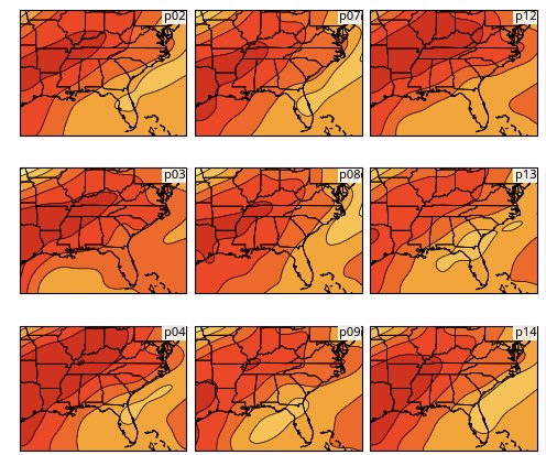
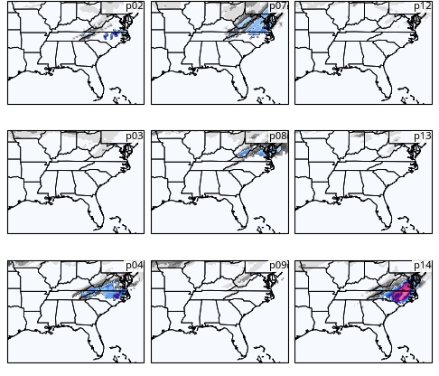
Thanks for your explanation. Here’s the surface of the relevant 6Z GEFS members as of the end of the snow period for portions of NC: what do they (2, 4, 7, and 14) have in common? lowest SLP both stronger and centered ~150-200 miles off SE coast:
-

2025-2026 New England Snow Recordkeeping Thread
CoastalWx replied to bristolri_wx's topic in New England
73.2 if math is correct. Think I told @The 4 Seasons72.7 before the half inch of crud last week. March looks to be a dud. -
Not asking me ...but "month of threats" overstates that? The rhetoric should really be "month of diminishing returns, but that doesn't mean zero" - that's painting a more realistic and fair picture, when factoring climatology, both standard and definitely CC-fixing. I can coherently sense these increasing limitations in the recent guidance tenors.
-
The problem with this extreme warmth this early as that it really kills the march ski season. For those who like to ski it’s annoying. But more importantly for these depressed mountain towns it really hasn’t affect on employment very sad end to what was a great ski season. about a month early. they’ll hang on for a few more weeks, but people just stop going.
-

2025-2026 New England Snow Recordkeeping Thread
Prismshine Productions replied to bristolri_wx's topic in New England
Bit behind so playing catch-up: +4" (3/3) +1.5" (3/5) 64.3" OTS Sent from my SM-S166V using Tapatalk -
It’s over
-
GFS drives 850s below freezing much sooner than anything else. Not much difference synoptically or in surface depiction between it and anything else. Just way too quick with post frontal CAA east of mountains with the passage of the strong arctic front. I could see flakes mix in somewhere in Virginia but this will not be more than that (and mountain snow). Not really worth over analyzing, GFS just defies physics while other models understand cold is delayed by the mountains
-
The 06Z GFS shows some post St. Pattrick's Day snow for the SC coast . That would cause some confusion for those who celebrated a little late the night before. They would wake up thinking they slept through spring, summer, and fall.
-
Don’t like it skip over it.
-
It's basically close the shades for the next week, then hopefully something starts appearing on models for the last 1/3 of March. Not ruling it out, but pretty boring for the foreseeable future.
-
It’s 3/10…still a month of threats to go. But we’re approaching the equinox and obviously anything we get will be gone relatively quickly. Old snow is always the most difficult to melt.
-
Extremely active storm track but fortunately it seems west of here for the near future. Possibly a significant tornado day in Texas and maybe even Illinois today. If energy keeps rising from Texas to Michigan we will keep catching tail end of systems with highest severe threats when they are this week west of here
-
So much talk about melting snow….does it really matter…it’s comical.
-
You just said yesterday it’s done…or were you just playing along with Scott?
-
It should be nearly or completely vanquished by Thursday morning. dews in the low-mid 50's overnight tomorrow: If you can survive that, then you might be able to retain it for a while afterwards.
-
Not a zero percent chance for something to pop
-
"1884: John Park Finley issued the first experimental tornado prediction. Finley studied the atmospheric parameters that were present during previous tornadoes. Many of these same criteria are still used by operational forecasters today. But the use of tornado forecasts would be banned just a few years later and remain forbidden until 1952." Why were forecasts banned? Do you know? Found this. http://site.extension.uga.edu/climate/2025/03/tornado-forecasting-was-banned-in-the-u-s-for-60-years-why/
-
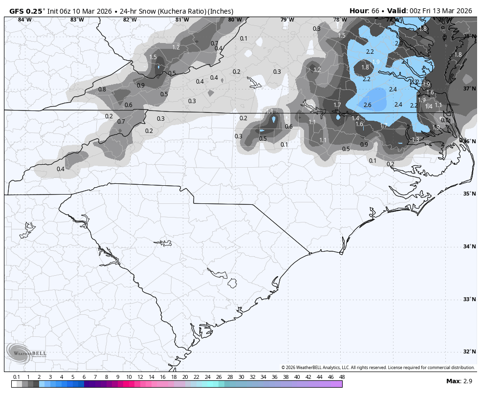
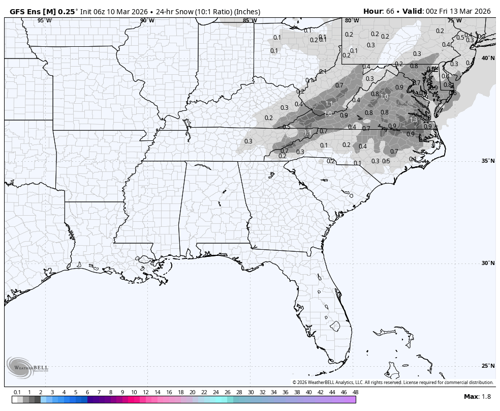
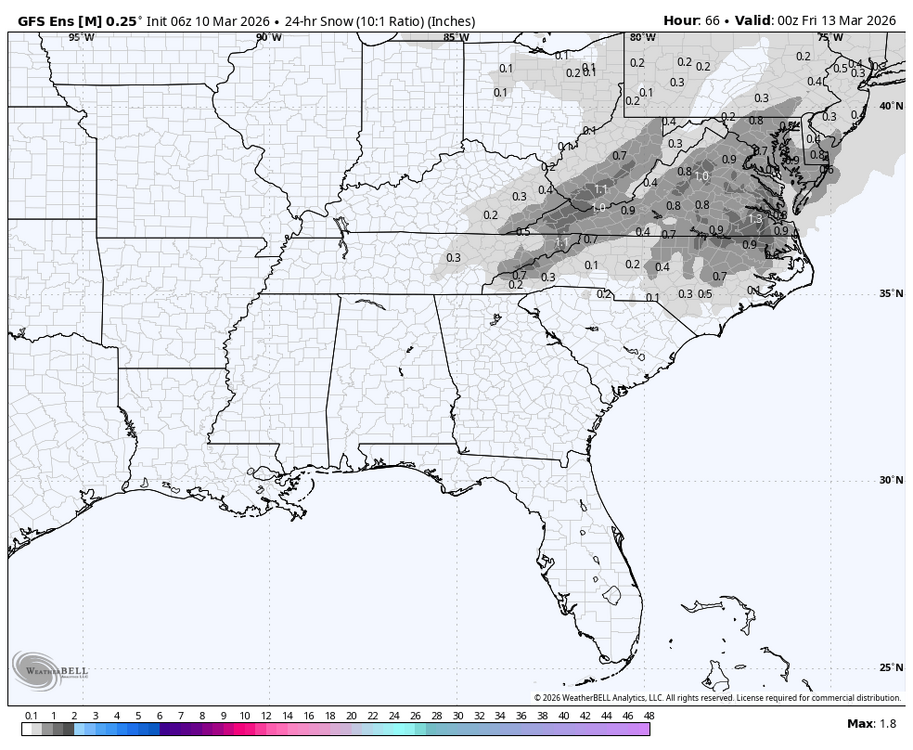
The 6Z GFS suite is looking really stupid in being on its own including all of the main short term models in showing a snow threat in portions of C and E NC on Thu (3/12). Why is the GFS showing this?? GFS (Kuchera): GEFS mean (10:1): GEFS mean is almost all from the clueless members 4 and 14 with a small assist by 2 and 7 while the other 26 members essentially have nothing outside of the mtns:

-
you know it's over when the conversation is about how fast the leftover snowpack and piles will melt
-
I can walk on this and there's plenty left right now.. some knew
-
Hard to knock a winter that started in late November and will finish with over 90" inches of snow, but having winter completely disappear after early to mid February along with the 3 complete melt offs in early December, Christmas, and early January take me from what would have been a A/A+ to an A-.
-
Track the Mets season. Let's go Mets! Let's go Mets! We'll miss the Polar Bear though....
-
I agree, it will go faster today...yesterday the dews slowed it, which was my original point.