All Activity
- Past hour
-
Up to 1.49" of rain since midnight and 2.35" for June Sent from my SM-G970U1 using Tapatalk
-
How bout that one Jns lol big booms
-
Not alot of strokes but they counted lol.
-
I was up for it. Almost every stroke was a ground stroke on storm one around 2:00
-
The cell that formed just to the west of Hanover and just went through Lewisberry looked to be a possible super cell on radar.
-
Between the storm at 2 and this one I've had at least 8 crazy close lightning strikes. Never in my life has the thunder kept me up most of the night. A couple of them actually shook the walls Sent from my SM-G970U1 using Tapatalk
-
Is definitely getting feisty out there. Nasty cell a few clicks to my south dropping powerful ground strokes atm.
-

Central PA Summer 2025
Mount Joy Snowman replied to Voyager's topic in Upstate New York/Pennsylvania
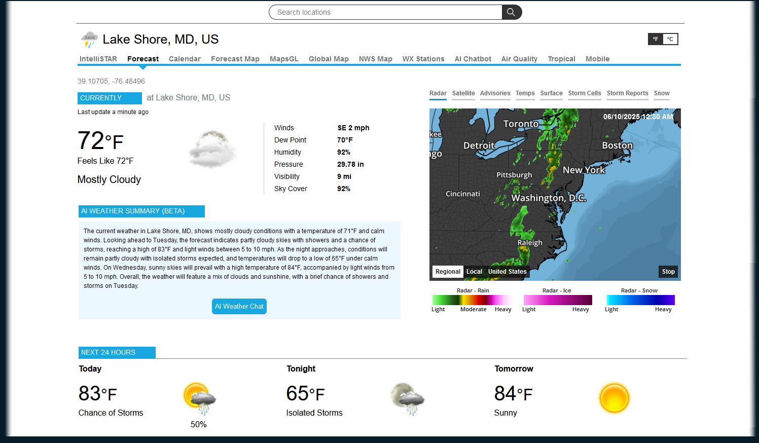
Low of only 66 with .15” of rainfall. Nice looking line to the west that could make for an interesting walk through Harrisburg this morning. -
1.96 rain for the month so far.
-
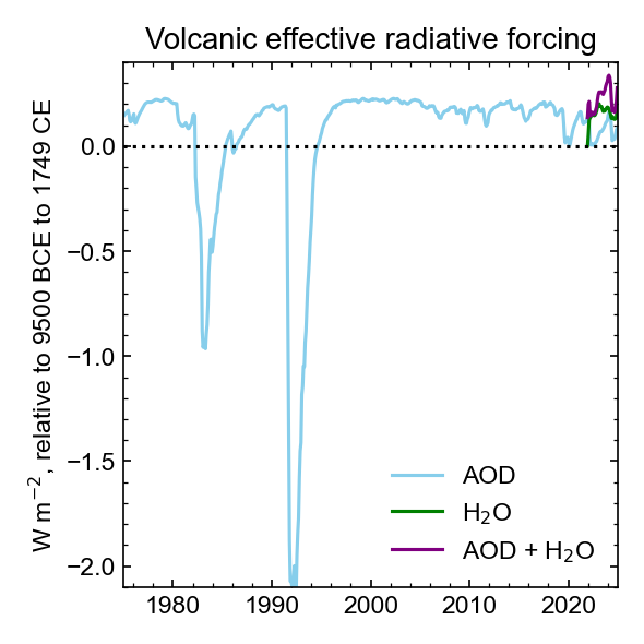
No I haven't changed my views. Here's an estimate of volcanic forcing through the end of 2024. Sulfur from HT has decreased faster than H2O, so the current impact of HT has changed from neutral to warming, but the effect is small, and partially balanced by a small volcano last year. Note that there has been a slight increase in volcanic activity in the past 5 years. So volcanoes would be producing a slight cooling without the HT water vapor.
-
53.6° -RA Everything is sobbing wet again. 0.23” through the tipper.
-
Reverse psychology for the win. Not much in the way of thunder, but it dumped so hard it woke me up. 0.61" out of it.
-
"Lower-than-normal forecast confidence heading into Friday, as guidance struggles with weak disturbances passing through the zonal flow aloft. The first chance for rain comes Friday morning as strong mid-level flow converges over SNE. There is little to no upper-air support, so it may be difficult to see more than just increased cloud cover and perhaps some weak showers. As for the weekend, guidance is in significant disagreement with rain chances as the GFS stretches a surface high into the region from the east, keeping us dry but cool for the weekend. The Euro and Canadian push the surface high further offshore, allowing a weak low-pressure system to exit the southern Great Lakes and move into the region. Examining the cluster analysis of all members from the GFS, Euro, and Canadian ensembles reveals that a wetter solution is favored, with only 14% of the ensemble members predicting a completely dry forecast. 56% of the ensemble members favor at least some light precipitation, while 30% indicate heavier precipitation and a washout." Our luck has to change at some point right?
-
Hey Charlie, Do you have any changed thoughts regarding the possibility of Hunga Tonga’s modern times unprecedented thrusting of so much water way up into the atmosphere being the main reason 2023 global temps had the sharp rise?
-
.86 rain overnight.
-
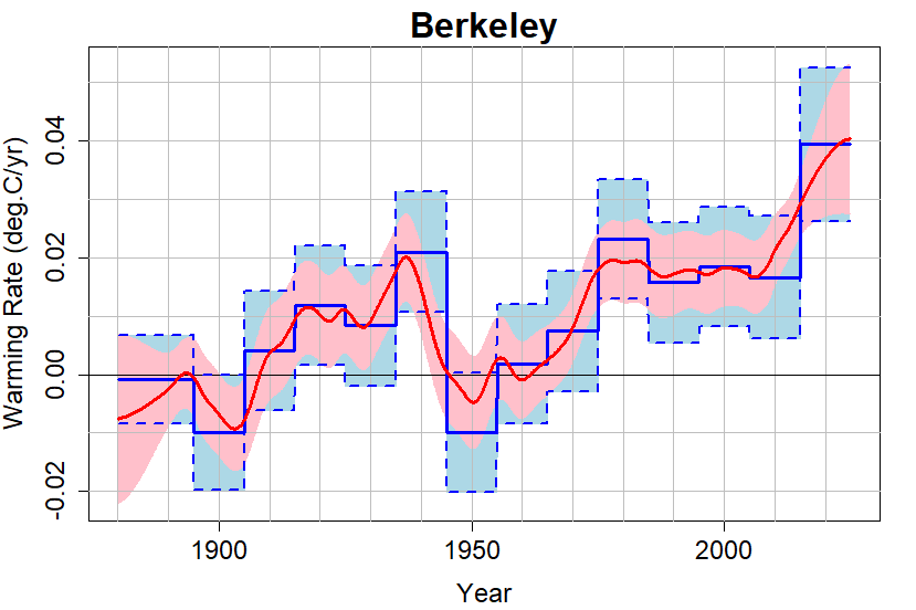
Blog article by Tamino on paper using statistics to determine if warming has accelerated. The paper is being revised in response to peer review comments. The updated statistics estimate that the warming rate has roughly doubled in the past decade. We are have received 2 decades of warming in the past decade. Tamino notes that some slowing off this spike should be expected. https://tamino.wordpress.com/2025/06/08/picking-up-speed/#more-12598
- Today
-

June 2025 discussion-obs: Summerlike
LongBeachSurfFreak replied to wdrag's topic in New York City Metro
Likely above average, 1-2 degrees. Absolutely agree about dews, lots of 88 with a dew of 75. Our climate is more resembling the coastal Carolina’s during summer. As the higher temps with lower dews combo migrates north to Montreal and Maine. -
 Caltian9721 joined the community
 -

2025 Short Range Severe Weather Discussion
HillsdaleMIWeather replied to Chicago Storm's topic in Lakes/Ohio Valley
I think that watch we had today might go down as one of the least severe producing ones we've had locally in years -

-
Meh, that's a lot of money to just use climo as a forecast
-
Warm and wet would be my guess. Prob another high dew summer.
-
Above average all time high averages, yes. But probably not too much extreme heat. I mean that's just gut bc long range forecasting is meh imo.
-
Kiosk mode no status...css. #statuspanel { display: none !important; } #statuspanel[type="overLink"] { display: block !important; }
-
i just took a look at my accuwx maps/temps lol
-
I ended up getting my 13th storm of the year, TWN snagged this one with pegged storms but WUN had the amount nearly down to the mm (I got 8mm, basically that was shown) and the 99% which for a squall line makes sense. Infrequent but bright, 'blooming' lightning. My ws didn't detect half of them strikes, I got 75.


.thumb.jpg.6a4895b2a43f87359e4e7d04a6fa0d14.jpg)