All Activity
- Past hour
-

December 2025 regional war/obs/disco thread
Torch Tiger replied to Torch Tiger's topic in New England
thank goodness this dark day and night bs is nearly over with. up up up! Cars will be warming in a few short weeks, and up to perhaps 80F-90? by early February -
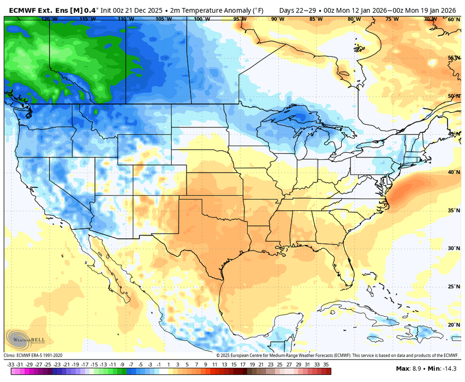
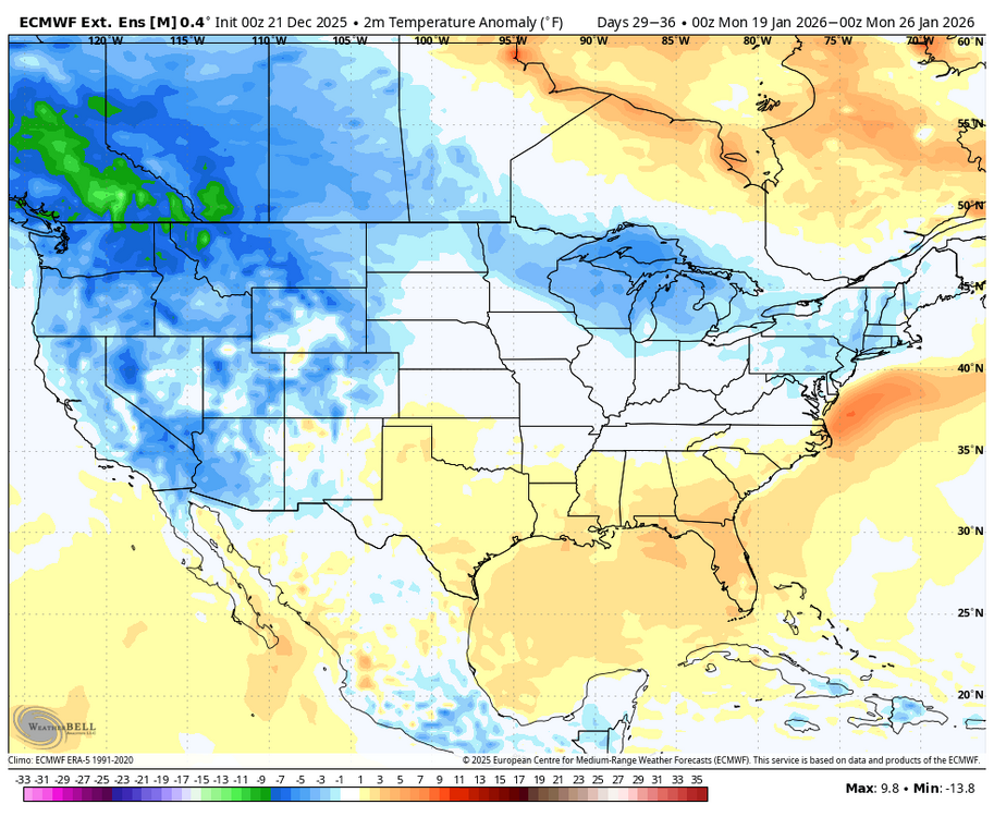
I continue to have a concern about certain WxBell maps being off. I’ve discussed the CFS being wacky and mainly too cold a number of times to @donsutherland1. But I also can’t figure out why their Euro Weekly (EW) maps are always colder than the ECMWF’s own EW maps! To me it just tells me that the WB EW maps are significantly too cold, period, which remains a concern. Why are they too cold? Here’s examples from today’s EWs: 1. For Jan 12-18th: ECMWF: AN ~80%, BN ~2% of US WxBell: why do they have… - AN in only ~1/3 of US vs 80% on in-house? - BN ~25% of US vs only 2% on in-house? ————- 2. For Jan 19th-25th: ECMWF: AN ~50%, BN ~ 3% of US WxBell: why do they have… - AN in only ~10% of US vs 50% on in-house? - BN ~50% of US vs only 3% on in-house?

-
Yes I deleted it. Drunk.
-
JB does have some good arguments though. TW
-

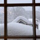
White Christmas Miracle? December 23-24th
tunafish replied to Baroclinic Zone's topic in New England
Map only showed through 1PM Tuesday. Back-to-Back holiday parties. -

White Christmas Miracle? December 23-24th
moneypitmike replied to Baroclinic Zone's topic in New England
He's taking Jeff's maps commment to heart. -

Possible Light Snowfall (1" - 4") on Tuesday Dec 23
eduggs replied to Northof78's topic in New York City Metro
I'm thinking 2" as the average across I-84 - not the upper limit - but with a wide range and maybe a funky regional distribution. I wouldn't expect uniform and consistent precipitation. I would guess the precip. shield is more banded and variable with winners and losers. But it's just a guess really. -

Possible Light Snowfall (1" - 4") on Tuesday Dec 23
MJO812 replied to Northof78's topic in New York City Metro
Nam shifted north -

White Christmas Miracle? December 23-24th
ineedsnow replied to Baroclinic Zone's topic in New England
might have -

2025-2026 ENSO
40/70 Benchmark replied to 40/70 Benchmark's topic in Weather Forecasting and Discussion
I think the +TNH will run a bit into Feb before we get very mild and await the stratosphere. -

White Christmas Miracle? December 23-24th
WinterWolf replied to Baroclinic Zone's topic in New England
Where Anthony’s post you quoted? Did he delete it? -
Agreed and makes sense. February here i’m expecting canonical Nina, which is usually a mixed bag of 60+ degree torches, rain/ice/sleet/snow overrunning events as the SE ridge waxes and wanes. January colder and mostly snow.
-
New BAM WX video says we're back into winter by mid-January. Here were my main takeaways from this video: 1. Dec 29-31 will trend colder, like it has been for the past few days. 2. He thinks there'll be a big storm favoring NE for the first week of January; his top analogs like 1996 and 2000 3. Somewhere between the end of Dec and the start of Jan, he thinks that WWBs will happen, causing: - the death of La Nina - -EPO by early Jan, but no +PNA - MJO to move very quickly and finally get unstuck thru phases 2, 3, 4, etc., finally getting back into 7 by around Jan 15 (just in time for prime climo) 4. He likes the fact that the PV is on our side of the hemisphere, and he thinks it'll stay there 5. The models are not seeing the cold in the long-range TL;DR: BAM WX believes that there will be a prolonged period of cold and stormy weather from Jan 15 to Feb 1. The first two weeks of January will likely offer shots of cold, but with relaxations in between.
-
White Christmas Miracle? December 23-24th
ineedsnow replied to Baroclinic Zone's topic in New England
more after that -

Possible Light Snowfall (1" - 4") on Tuesday Dec 23
snywx replied to Northof78's topic in New York City Metro
Are you thinking more than 2" here in the 84 corridor? Im thinking 2" is prob the upper limits in this area. Maybe some 3-4" amounts in the Catskills -
White Christmas Miracle? December 23-24th
ineedsnow replied to Baroclinic Zone's topic in New England
0z NAM coming back north but was pretty far south at 18z -

White Christmas Miracle? December 23-24th
Sey-Mour Snow replied to Baroclinic Zone's topic in New England
HRRR shows it Putnam CT to Boston this run.. it will waffle.. instead of 2-3" that screw zone will be half inch to an inch .. Also parts of SW New England may miss out in this event entirely have to watch out for that.. SW Fairfield County in particular -
Possible Light Snowfall (1" - 4") on Tuesday Dec 23
eduggs replied to Northof78's topic in New York City Metro
Considering just about all guidance has 0.2" liquid or more across NNJ and SENY and a snow-supporting model profile, those WPC snow maps look low. You would seemingly have to go against model consensus to come up with those probabilities. Or maybe they are heavily skewed towards the GEFS. Either way, the lack of granularity across our region makes it only modestly useful. -
White Christmas Miracle? December 23-24th
Sey-Mour Snow replied to Baroclinic Zone's topic in New England
It could be anywhere in that area equal chances.. -
December 2025 regional war/obs/disco thread
Torch Tiger replied to Torch Tiger's topic in New England
I have a <3 for all the west-facing ridgelines near those ORH hills and up into NH. -
December 2025 regional war/obs/disco thread
Torch Tiger replied to Torch Tiger's topic in New England
sweet spot! -
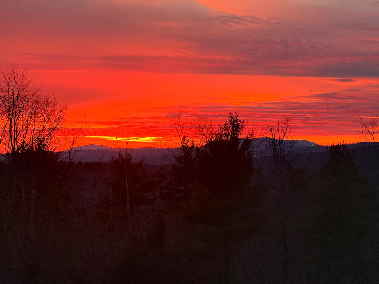
This was the sunset yesterday with the lights from Pats Peak visible to the right:

-

Possible Light Snowfall (1" - 4") on Tuesday Dec 23
Birds~69 replied to Northof78's topic in New York City Metro
Steve D, enough said.... -
Possible Light Snowfall (1" - 4") on Tuesday Dec 23
MJO812 replied to Northof78's topic in New York City Metro
HRRR shifted south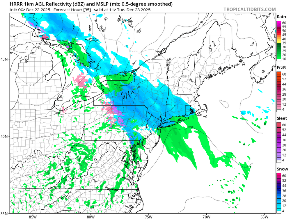
.thumb.png.d01683a044485f8356a649e61f33bf4f.png)
-

Possible Light Snowfall (1" - 4") on Tuesday Dec 23
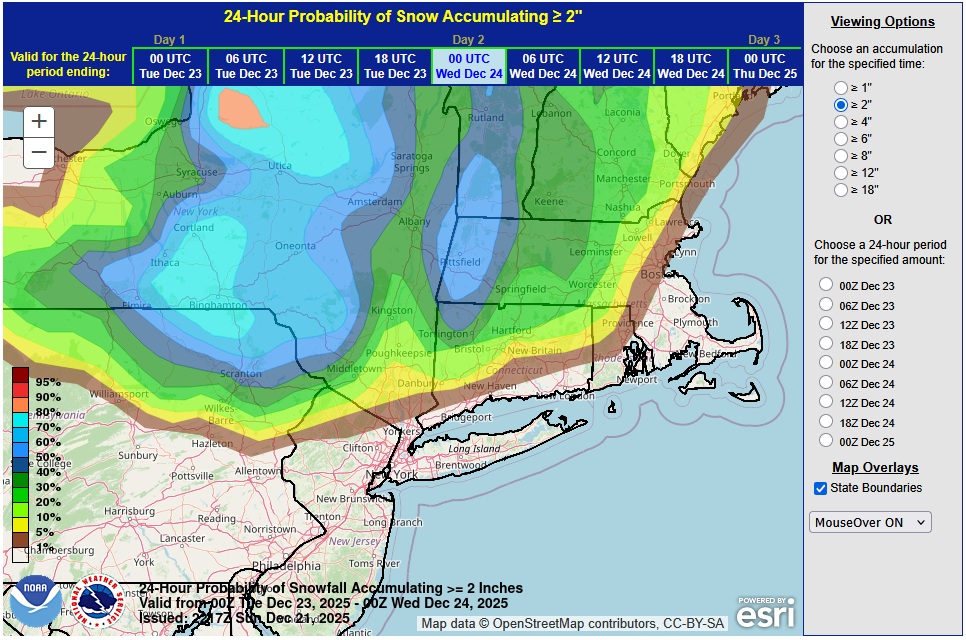
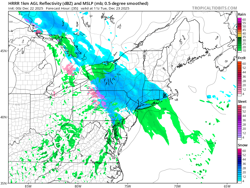
donsutherland1 replied to Northof78's topic in New York City Metro
No changes in thinking at this time. With marginal temperatures and light precipitation rates, most of the New York City area will probably see little more than a coating. The City will likely see temperatures remain above freezing for most or all of the storm. A trace of snow cannot be ruled out for parts of the City. Nearly three-quarters of events with temperatures above freezing saw no measurable snowfall while just one-in-six had 1" or more in Central Park's climate record. It is possible that the precipitation could mix with or end as some light rain or drizzle in and around New York City. The distant northern and western suburbs continue to have the best chance of seeing 1"-2", as readings will likely be near or perhaps even a little below freezing during much of the event. The latest WPC maps for 24-hour probabilities of 1" or more and 2" or more snowfall are below: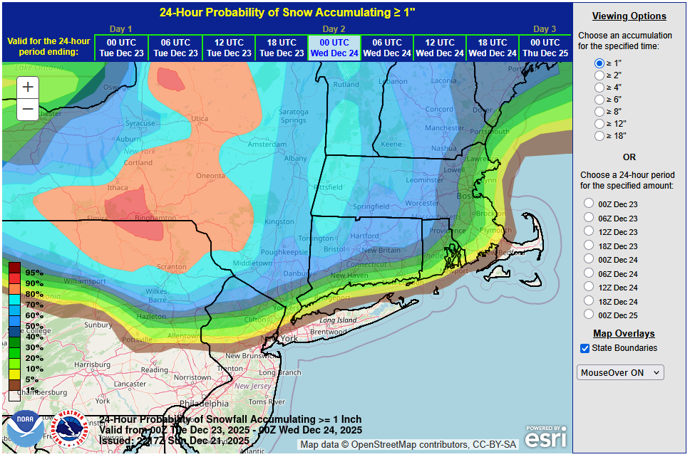


.png.8e1dd6ced38ed4a5839283e2fa9b33e4.png)