All Activity
- Past hour
-
That will change
-
Bring it! Will be nice to take hour walks in the morning without dripping buckets of sweat.
-

2025 Atlantic Hurricane Season
BarryStantonGBP replied to BarryStantonGBP's topic in Tropical Headquarters
and what about NS forecasts just don't want the funniest name wasted on a crap system
- Today
-
Judging by current radar I would say yes. Looks to be steining most of CT.
-

Hurricane Erin: 105 MPH - 958 mb - NNW @ 10
Coach McGuirk replied to BarryStantonGBP's topic in Tropical Headquarters
Hurricane Isabel 2003 165 MPH -
Hurricane Erin: 105 MPH - 958 mb - NNW @ 10
Coach McGuirk replied to BarryStantonGBP's topic in Tropical Headquarters
It was a pin needle cat 5 for a minute. -
Same here. Looks like the 90s are done early for the year. The bad news: Very short-lived garbage pattern ahead for the next few days. Although a bit early for this, but back-to-back days of expected suicide weather starting tomorrow. The good news: Nice pleasant weather takes over just before this weekend begins with temps rebounding back to the lower 80's for Friday into Saturday. Temps really cool down big time early next week. Highs are forecast to be in the low 70s, though there are areas that could be stuck in the 60s or even upper 50s! GFS 00z Monday: GFS 00z Tuesday: Overall, we're reaching what it appears to be the final nail in the coffin on this summer.
-

Summer 2025 Medium/Long Range Discussion
Spartman replied to Chicago Storm's topic in Lakes/Ohio Valley
Summer is over -
Hurricane Erin: 105 MPH - 958 mb - NNW @ 10
Coach McGuirk replied to BarryStantonGBP's topic in Tropical Headquarters
The most talked about nothing hurricane ever? -
2025 Atlantic Hurricane Season
BarryStantonGBP replied to BarryStantonGBP's topic in Tropical Headquarters
So the EPAC hogs the peak season -

2025-2026 ENSO
Stormchaserchuck1 replied to 40/70 Benchmark's topic in Weather Forecasting and Discussion
18-19 and 20-21 through 22-23 -NAO's were really not getting cold at all. The last 2 Winters, there has been cold under -NAO patterns in the east, and the Mid Atlantic has done better in those times. -
2025-2026 ENSO
Stormchaserchuck1 replied to 40/70 Benchmark's topic in Weather Forecasting and Discussion
Down below 5190dm over the Arctic circle Aug 22-25. It's doing exactly what that +AO roll-forward showed, in the exact location, albeit a few months early. I thought this was impressive because the Polar Vortex was 2000 miles from where the base +AO period had negative H5. -
Down below 5190dm over the Arctic circle Aug 22-25
-
Thursday I will have been 75 or under for a high 4 straight days. Yesterday it didn't get out of the 60s. Hard to believe it won't be cold enough to snow in the Winter unless we stumble into a really bad upper latitude pattern. The cold next week (more days with highs in the 70s) is largely -EPO driven. Aug -EPO is actually a colder-Earth pattern, when you roll it forward into Jan-Feb the correlations are pretty high on the below average side generally I was stressing the cold H5 over Greenland May-July. It's moderated now, but has been proceeded with some cooler indicator conditions. Last year there was cold H5 over Greenland May-Sept, this moderated in the Fall.. this year it's the same thing but maybe 1 month early on the moderation. Give me cold H5 earlier in the year, I don't care if it's +NAO (unless it's the Winter).
-
A nice soaking rain. I prefer dry but this will help the farmers and foliage.
-
Delayed report but we ended up with just under 4” of rain in 24 hours on Monday into Tuesday. Four separate thunderstorms made for a fun day.
-
 Same here. Pretty good evidence tonight that if there is going to be very heavy rain, it will likely be to the south. Most of the 0z models give our area a quarter to half inch. I'd be very happy to get a half inch. I see the HRRR backed off on the insane amounts, but it still does show some isolated 5 to 6 inch amounts so the south.
 -
I like that but a few rain events mixed in would be great to keep the dust clouds at bay and the trees from getting too droopy. It’s been a rough stretch these last few weeks in the water department.
-
Hello, Long-time member, rare poster except obs and such. Voracious reader of all of your expertise, however! I must say in this thread: Hurricane Erin has the making of an epic wave-producer for all my New England brothers and sisters who will hit it as it pulls away. National Weather Service Coastal Marine Forecast below (posted as plain text so hope it doesn't run off the screen to the right). -- Coastal Waters from Montauk NY to Marthas Vineyard extending out to 20 nm South of Block Island- 1004 PM EDT Tue Aug 19 2025 ...SMALL CRAFT ADVISORY IN EFFECT THROUGH THURSDAY MORNING... ...GALE WATCH IN EFFECT FROM THURSDAY MORNING THROUGH FRIDAY AFTERNOON... . THU...NE winds 20 to 25 kt with gusts up to 35 kt. Seas 8 to 11 ft, building to 10 to 13 ft in the afternoon. Wave Detail: E 8 ft at 7 seconds and S 7 ft at 15 seconds, becoming S 9 ft at 17 seconds and E 8 ft at 7 seconds. A chance of rain in the morning. . THU NIGHT...NE winds 25 to 30 kt with gusts up to 40 kt. Seas 12 to 15 ft, building to 13 to 18 ft after midnight. Wave Detail: S 12 ft at 17 seconds and E 10 ft at 7 seconds, becoming S 14 ft at 17 seconds and E 10 ft at 8 seconds. . FRI...NE winds 25 to 30 kt, becoming N 20 to 25 kt in the afternoon. Gusts up to 40 kt. Seas 14 to 18 ft, subsiding to 11 to 15 ft in the afternoon. Wave Detail: S 13 ft at 17 seconds and NE 10 ft at 8 seconds, becoming SE 10 ft at 14 seconds and NE 9 ft at 9 seconds. -- NHC track: Very reminiscent of Erin on 9/11, when I was out three different time around Narragansett, Rhode Island area. I'll miss this one. I am visiting family and friends in Boston for my birthday til Thursday, then back to Brattleboro, Vermont. Argh. Seriously, if you are not extremely skilled, do not try to play the hero. You'll most likely drown. Oh yeah, very nice seasonable weather of late, finally, in Brattleboro! I do full-time landscaping, and the 100 heat indexes and 90-plus and very humid for like six weeks kinda hurt.
-
Today’s Euro Weeklies have the 3rd week in Sept (9/15-21) for the first time and it is as Barry’s image above shows near the 2005-24 ACE avg. Regarding progged ACE in Sept from today’s run: after a well BN 1st week and a moderately BN week 2, week 3 (near normal) is significantly more active and actually has the most ACE of any of the 4 weeks by a good margin starting with the final week of August. This is giving me flashbacks to 2024 as this is at least hinting at a Sept resembling last Sept, which had a much more active 2nd half than first half. I’m guessing that this prog of relative quiet in week 1 transitioning to normal active in week 3 is MJO related. Here are today’s EW ACE forecasts: 8/25-31: 9-10 9/1-7: 5-6 9/8-14: 8-10 9/15-21: 13-15
-
Stop right there and vet your sources.
-

Hurricane Erin: 105 MPH - 958 mb - NNW @ 10
Wannabehippie replied to BarryStantonGBP's topic in Tropical Headquarters
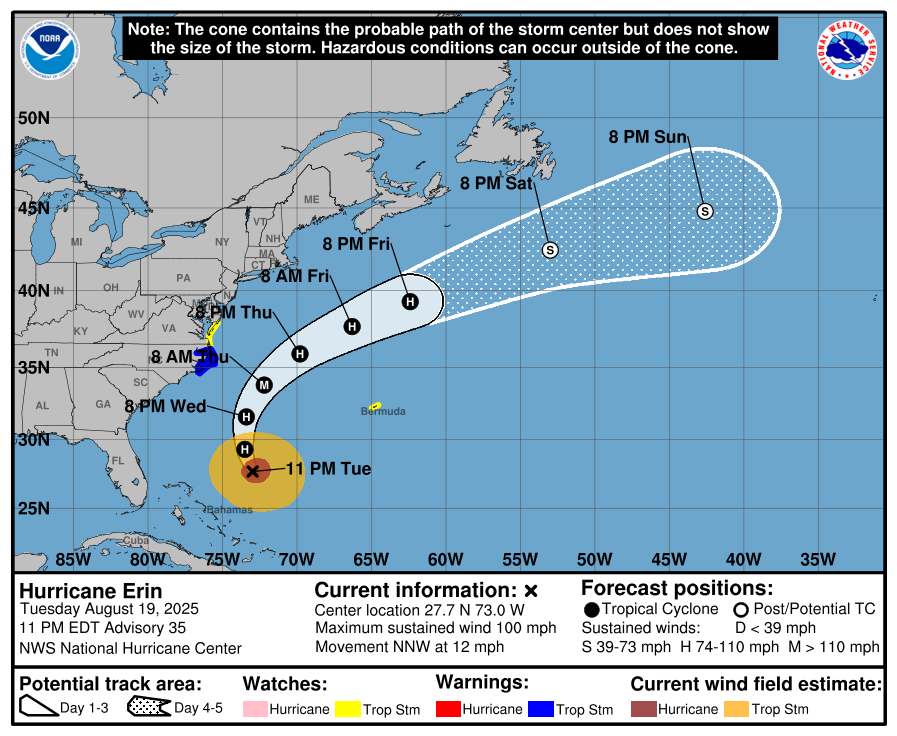
11:00 PM EDT Tue Aug 19 Location: 27.7°N 73.0°W Moving: NNW at 12 mph Min pressure: 959 mb Max sustained: 100 mph -

Hurricane Erin: 105 MPH - 958 mb - NNW @ 10
wthrmn654 replied to BarryStantonGBP's topic in Tropical Headquarters
The eye is at 73W and just under 28N That seems kinda west of the last 2 eye passes from plane no? -
Hopefully a summery and dry September into October. It's the busiest months of the year around these parts for various events.


.thumb.png.4150b06c63a21f61052e47a612bf1818.png)


