All Activity
- Past hour
-

2026-2027 Super El Nino
GaWx replied to Stormchaserchuck1's topic in Weather Forecasting and Discussion
Nino 1+2 came in at +2.6 vs my guess of +2.7 to +2.8z Nino 3.4 rose only from +1.2 to +1.3 vs my guess of a rise to +1.4. The daily OISST had suggested a rise of 0.2 rather than 0.1. Perhaps the rise was just under 0.15 and this rounded down to a rise of 0.1? But also, the image below of relative OISST for 3.4 suggests the relative 3.4 for last week (7/5-7/11 or the last 7 dots) was actually ~+1.5. So what’s going on? How come NOAA had it at only +1.3 being that they state it is OISST based? The +1.3 and this chart don’t jibe: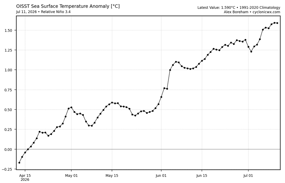
-
 This is interesting wording for NNE tomorrow: Given the degree of instability and strength of the flow, severe thunderstorm winds are likely (some significant). Large hail will also be possible with any storms. Additionally, forecast soundings show enough low-level curvature to support a tornado threat, including a strong tornado or two, with any sustained surface-based supercell.
 -
(002).thumb.png.6e3d9d46bca5fe41aab7a74871dd8af8.png)
Central PA Summer 2026 Discussion/Obs Thread
ChescoWx replied to Voyager's topic in Upstate New York/Pennsylvania
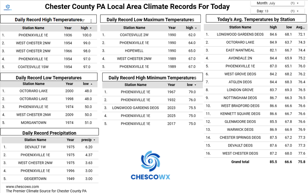
Several of our valley locations this morning saw lows down into the 50's with the ridges remaining in lower 60's. The lowest I could find was 56.3 at the Warwick DEOS. Today will be our 6th below normal temperature day over the last 8 days. We turn that around tomorrow with highs well into the 80's with 90's in the valley spots. Widespread 90's on Wednesday before we back off several degrees by Thursday. So not many spots across Chesco will get to "enjoy" the so called "heat wave" this week. By next weekend we return to near normal temperatures with increasing chances of some showers.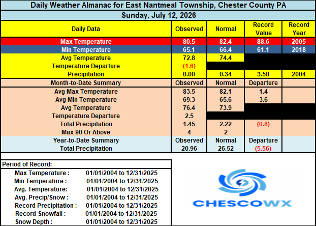
-
 And what people are not going to realize to when it comes to the power companies is a 38-like track would mean substantial power outages from LI through New England and probably even into eastern NY. All these markets would be tied up...we would obviously have to rely on help from other states but with the help that would be needed...I don't think we would be able to get the help needed. Obviously first priorities are going to be police/fire/hospital grids. Any people sharing those grids will be the luckiest...at least in terms of getting power restored quickest.
 -
E PA/NJ/DE Summer 2026 Obs/Discussion
ChescoWx replied to PhiEaglesfan712's topic in Philadelphia Region
Several of our valley locations this morning saw lows down into the 50's with the ridges remaining in lower 60's. The lowest I could find was 56.3 at the Warwick DEOS. Today will be our 6th below normal temperature day over the last 8 days. We turn that around tomorrow with highs well into the 80's with 90's in the valley spots. Widespread 90's on Wednesday before we back off several degrees by Thursday. So not many spots across Chesco will get to "enjoy" the so called "heat wave" this week. By next weekend we return to near normal temperatures with increasing chances of some showers.
-
 Having spent 9yrs in S FL I have a new appreciation for preparedness. Most folks (not all) had some sort of season storm kit with food and other supplies. All it’s going to take here is a strong Cat 1 or 2 and people will be out of power for a couple of weeks losing their shite on the power companies. We have have had significant tree growth since Gloria and Bob and many have not idea what widespread tree damage will look like.
 -
 please please let it happen.. I know many people here that don't think a Hurricane can even happen here.. the ones that do say it wont be bad even if one hit.. I honestly hope a big one hits soon!
 -
 Beats my longest - 6 days from the Jan 1953 ice storm on the hills north and west from NYC. 2nd place is 101 hours from the Dec 18, 2023 gales/flood and 3rd was 90 hours in Jan 1998. We were fortunate in that last one - a single break between Brunswick Avenue and our place 400' away would've meant 2 weeks. (Our phone was out for 13 days.)
 -
I think we may see 10%/45%/30% on new D2
-
 You and PF may want to keep an eye on this.
 -

2026-2027 Super El Nino
40/70 Benchmark replied to Stormchaserchuck1's topic in Weather Forecasting and Discussion
If possible, 1941-1970 and 1961-1980 would be ideal. -
Charlie you keep avoiding my question for the years I am highlighting in the chart 1927-1951. There are 16 years before 1942. To make my question clearer I updated the chart (see below) to add the delta between Allentown and Chesco. You again never answer the question so I will ask it again later. By the way in looking at the surrounding nearby stations at the Navy Yard and Point Breeze it looks clearly like opening of the more rural location with less runways and building etc. at the new PHL Airport resulted in the new site being 1.6 degrees colder than the neighboring Navy Yard in 1941 and continued to run at least 1 degree colder than Point Breeze every year through 1951. So you have to wonder why NCEI failed to warm the new PHL airport site during those years due to the station move to a more rural/colder location? But even without the likely need to warm PHL for those years - the facts remain the same PHL was and is always warmer than average Chesco in every single year except one (1943) ! So I will try again - a simple question why is all of Chester County altered and adjusted to an average temperature for 17 years during this period to colder than Allentown PA?? This is 2 counties north and 50 miles away? Not just Coatesville Charlie - the average of all of these stations. Sorry Charlie in no world should the average temperature for those 25 years have Allentown at 51.8 and the all Chesco Avg. colder at 51.7 Why is NCEI correct based on their adjustments that Chester County should be altered and adjusted to be colder than Allentown for a quarter of a century based on these chilling alterations to the data? Can you answer that?

-

Central PA Summer 2026 Discussion/Obs Thread
Itstrainingtime replied to Voyager's topic in Upstate New York/Pennsylvania
I think they're going to hoist an Excessive Heat Warning for Wednesday later today or tomorrow. -
Beautiful Day for a Walk Warning in Effect! Can't beat today in mid July,,,,,ENJOY!
-

2026-2027 Super El Nino
LakePaste25 replied to Stormchaserchuck1's topic in Weather Forecasting and Discussion
Hadley cell expansion is actually increasing the size and latitude (poleward) of subtropical ridging. Not *every ridge* but subtropical ridges. https://acp.copernicus.org/articles/20/5249/2020/index.html But to your point, that’s also true that baseline GPH goes up as well. That’s why whenever I look at past years, I use the climate period that fits that year whenever possible. For example: 1972 -> use 1961-1990 1982 -> use 1971-2000 etc otherwise it’s difficult to pick out a signal when these past years have too much troughing using the much warmer 1991-2020 baseline. Unfortunately the tools that use the correct climate period are not always available. -
2026-2027 Super El Nino
40/70 Benchmark replied to Stormchaserchuck1's topic in Weather Forecasting and Discussion
Yea, we aren't getting a "high-end" season with an El Nino that potent even if everything worked out perfectly...just too great a volume of Miller A systems. I will bet anything that the signature storm of the season will jackpot the mid atlantic...maybe we still get slammed, but to a lesser extent. Our ceiling this season is normal to maybe about 10-12" above normal snowfall....like 1965-1966. But odds strongly favor less than that. -
Nice. Haven't seen a good after-dark light show in years.
-
100*F+ seems fairly likely for Detroit tomorrow. About as perfect as a setup as you can get...
-
Let's say a 1938-style hurricane were to be possible (same track, strength, etc). There probably would be some people which take the threat seriously, however, I'm nervous the vast wouldn't. I would assume, however, mandatory evacuations would be ordered at least for the coast which would help but most people I would think probably evacuate inland, particularly if they have friends/family in-state. But I don't think how many people realize just how bad the power outages situation would be. This would be an order of magnitude (or two) greater than Oct. 2011. 80-90% of the state would be without power for weeks and a large portion of that probably at least a month and it could be longer if any substations are completely destroyed. From my understanding, much of the equipment is build overseas and you just can't fly that stuff over, its gotta be shipped by boat and that stuff takes time to build as well. Grocery stores will have generators but could end up being some shortages of food and even gas. It would be ugly
-
Might be a homebrew year later in the season with warm SSTs and troughs that start to develop and dig into Plains/Midwest.
-
2026-2027 Super El Nino
40/70 Benchmark replied to Stormchaserchuck1's topic in Weather Forecasting and Discussion
Appreciate that...no worries at all. We're all very passionate about the weather. -
 Stein thru the week at a minimum. Very dry again
 -
 I can already tell you that people will meh a hurricane all the way until landfall. And then complain they didn’t get the eyewall.
 -
Portland may get absolutely drilled.
-
2026-2027 Super El Nino
GaWx replied to Stormchaserchuck1's topic in Weather Forecasting and Discussion
Chris, thanks. A rise in H5 hts in a warming world makes perfect sense, of course. Per your graph, the bulk of the rise in winter in the portion of the globe that you specified has been since the early 1990s and there’s been a rise of ~4 dm from ~530 to ~534 since then. In a warming world, we know that both the avg ridge and the avg trough H5 ht. will naturally be higher. But relative to each other, wouldn’t the differential remain ~same? I’ll make up some #s to illustrate my Q: -let’s say that in the early 1990s that the avg ridge for the entire globe year-round was 575 dm and the avg trough was 540 dm -let’s say that in the early 2020s that the avg ridge was 580 dm and the avg trough was 545 dm. The avg of each has to rise with a warming globe. -That would mean that the mean difference remained at 35 dm. So, relative to the avg trough/ridge, the avg ridge/trough wouldn’t be stronger/weaker assuming this hypothetical example were near reality