All Activity
- Past hour
-

“Cory’s in NYC! Let’s HECS!” Feb. 22-24 Disco
bristolri_wx replied to TheSnowman's topic in New England
.thumb.png.f8891ebc5930139c87a5a0daf6c48413.png)
-

“Cory’s in NYC! Let’s HECS!” Feb. 22-24 Disco
40/70 Benchmark replied to TheSnowman's topic in New England
Too bad he wouldn't check out Telerican Weather and spend some time on that site. -

Feb 22nd/23rd "There's no way..." Obs Thread
ravensrule replied to Maestrobjwa's topic in Mid Atlantic
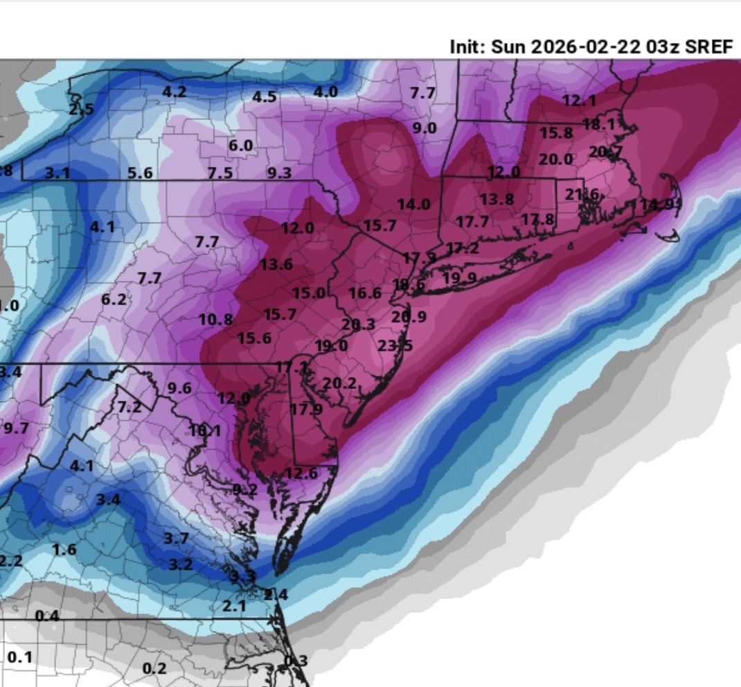
The Sref not as good as the last one.
-
Sref is very consistent

-
Snowfall rates can jackpot with thunder snow. Though I have seen it go either way. Either heavy snow, or a change to sleet!
-
Feb 22nd/23rd "There's no way..." Obs Thread
ravensrule replied to Maestrobjwa's topic in Mid Atlantic
1,000%, terrible job. We miss you Randy, please come back. -

Feb 22nd/23rd "There's no way..." Obs Thread
Silver Meteor replied to Maestrobjwa's topic in Mid Atlantic
The Low is forming now on the Carolina Coast: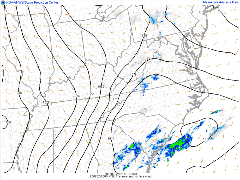
-
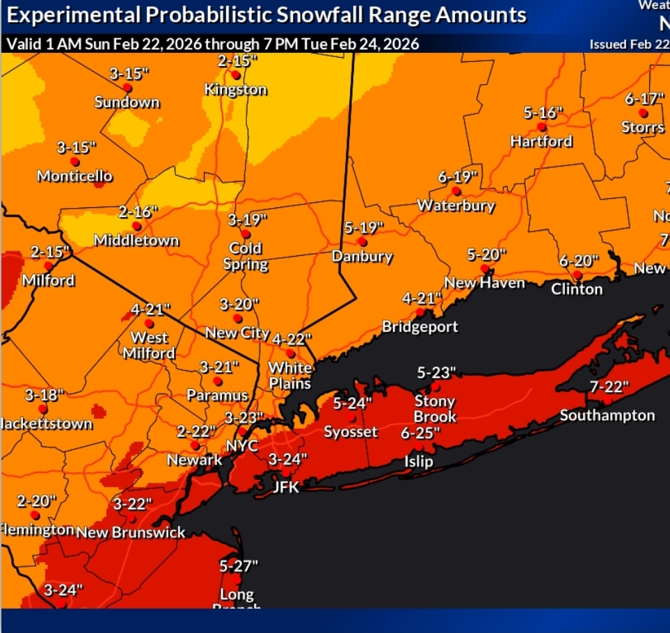
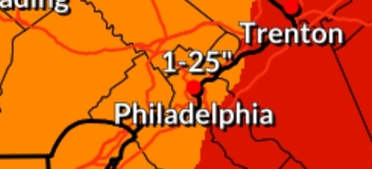
Upton hedging with 3-23" lol Mt. Holly has a crazier 1-25" for Philadelphia
-
You really should check out Darfford this time of year.
-

Feb 22nd/23rd "There's no way..." Obs Thread
stormtracker replied to Maestrobjwa's topic in Mid Atlantic
You’re fired. -
My question now is what is everyone's opinion on what could go wrong with this storm causing much lower snowfall amounts then modeled in certain areas ? One area I think that is overdone is the NAMS 42 inches on the Ocean County coast .
-
That low does NOT want to move wow
-

2/23/26 Last Chance SEVA Snow Threat
Coach McGuirk replied to Coach McGuirk's topic in Southeastern States
Just barely in a winter storm warning for 2-4 inches of snow Sunday night. -
How, on the eve of a HECS, does one possibly find themselves so downtrodden they are reduced to looking at D11 2m temp maps? Look... I'm here, too, losering it up, so I can say that. 12°F
-
“Cory’s in NYC! Let’s HECS!” Feb. 22-24 Disco
40/70 Benchmark replied to TheSnowman's topic in New England
Grape flavored Crystal Lite water...recovering alcoholic with 4 little kids After examine the mid levels of the EURO, this looks like Juno and March 14, 2018. I just mean with respect to placement of the band, so don't get spooked out west.....different evolution this time. -
Just barely in a winter storm warning for 2-4 inches of snow.
-
Snows itself out
-
IMO its impossible for any model to pinpoint exactly where any extreme amounts will fall caused by banding - have seen that happen in many storms over the years.
-
Good luck to the interior crew. My yearly visit to here. I hate (bc I'm jealous) how peaceful it is in here lol.
-

“Cory’s in NYC! Let’s HECS!” Feb. 22-24 Disco
78Blizzard replied to TheSnowman's topic in New England
SREF held serve at 03z from 21z. Still a crushing. -

“Cory’s in NYC! Let’s HECS!” Feb. 22-24 Disco
WxWatcher007 replied to TheSnowman's topic in New England
Thite plains sounds like a lovely place. -
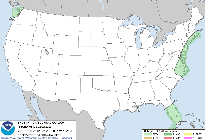
SPC is forecasting a thundersnow risk! ...Discussion... Strong short-wave trough is digging southeast toward the OH Valley late this evening. This feature will phase with the southern stream and induce a surface low off the NC coast early in the period. Intense deepening is expected with this offshore cyclone which will lift north-northeast during the overnight hours. Isolated thunderstorms may develop along the trailing cold front as it surges south across the FL Peninsula during the day, but poor lapse rates and weak buoyancy suggest the risk for robust convection is not particularly high. Intense low-level warm advection will aid the potential for lightning discharge in midlevel convection along the middle Atlantic coast and southern New England. Forecast soundings suggest the majority of this activity will be within heavier snow bands along the northwest-north side of the cyclone. Across the Pacific northwest, significant midlevel cooling and steepening lapse rates are expected along the WA coast by early afternoon. Weak SBCAPE is expected to develop across this region and some risk for lightning is possible with convection that develops within this warm-advection regime.
-
Did anyone post the 3z RAP?
-

“Cory’s in NYC! Let’s HECS!” Feb. 22-24 Disco
TheSnowman replied to TheSnowman's topic in New England
https://www.wcvb.com/article/massachusetts-snow-storm-blizzard-warning-noreaster/70448418 Does this channel think CT & the rest of the storm doesn’t Exist? Lol -

“Cory’s in NYC! Let’s HECS!” Feb. 22-24 Disco
WeatherGeek2025 replied to TheSnowman's topic in New England
my snowmap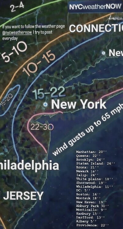
.png.d177b9af340b8c608cec3da2a61c015e.png)