All Activity
- Past hour
-

White Christmas Miracle? December 23-24th
RUNNAWAYICEBERG replied to Baroclinic Zone's topic in New England
I believe he lives in the armpit of the country now…Florida. -

December 2025 regional war/obs/disco thread
WinterWolf replied to Torch Tiger's topic in New England
Ok, I like that…We enjoy . -
December 2025 regional war/obs/disco thread
RUNNAWAYICEBERG replied to Torch Tiger's topic in New England
Snowy Friday night incoming. Lean back and enjoy it. -
One thing to note is that surface temps are really cold to start. Could be some high ratio snows and better than 10:1
-

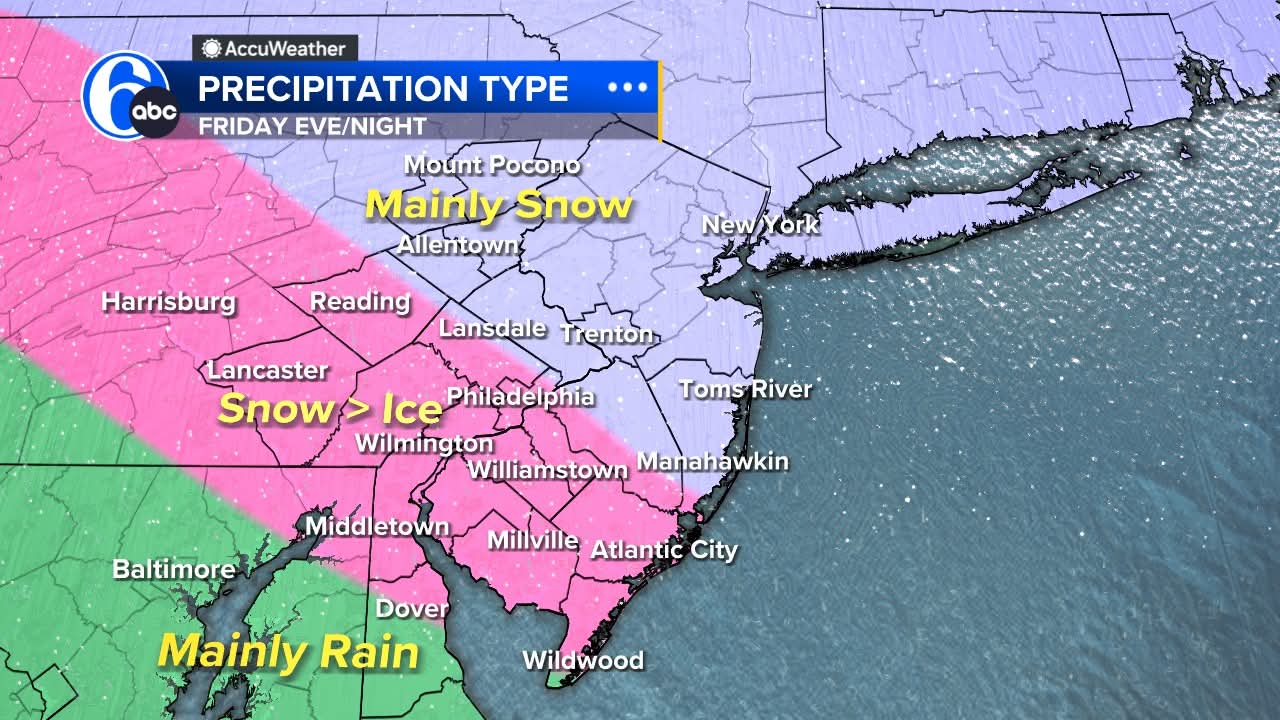
Boxing Night Snow/Sleet/Ice Dec 26-27 Storm Thread/Obs.
Birds~69 replied to Mikeymac5306's topic in Philadelphia Region
Adam Joseph 6abc around 6pm on Facebook a couple hours ago: POST CHRISTMAS STORM First off, thankfully Christmas Eve & Christmas Day will be quiet! Santa will have some strong winds helping him make the rounds, and only a few sprinkles are expected near lunch on Christmas Day. Highs both days in the middle 40s. Now, to Friday!!! A piece of the nasty storm in California will break off and head across the country setting its eyes on the Mid Atlantic for Friday afternoon and night. The issue will be a large area of Artic High pressure in southern Canada. This will send down very cold air from the surface to thousands of feet up. Cold air is dense and heavy so it will be locked in as the storm arrives. The issue then becomes warm air trying to move in in the upper atmosphere as the storm ramps up. Warm air is light and buoyant, so it wants to settle where the precip forms in the storm in this kind of setup. Precip cannot turn to snow after it forms if the air temp is above freezing, so this is crucial in a mixed storm. Depending on the column of air temps from the layer where precip begins, to the ground will supply either rain (above freezing at all levels), freezing rain (shallow cold at only at surface), sleet (deep cold layer under the precip formation zone), and snow (below freezing at all levels). Our area will see all this mess.....the question this far out is where those areas set up. I do not see much rain with this system right now....more snow, sleet, and freezing rain. Some areas will see over 3" of snow! I will be off enjoying two days with my family and will be back to guide you through it all on Friday. Please tune it to Payton and Brittany for the latest. Just wanted to give you a heads up and my current thinking. Right now, this is our thinking and it will be fined tuned the next two days. Please share this in case people are not watching or on social at this time: TIMING: snow for all mid to late afternoon Friday HEAVIEST: falls near dark Friday through Midnight CHANGEOVER: Snow flips to ice in much of the area starting Friday evening. ALL SNOW: looks to be north of the PA Turnpike with less mixing with ice. AVOID TRAVELING: late Friday afternoon into Saturday morning.
-
There will be high ratios with this storm whoever is under the heavy banding.
-
i'd take the 2-5 and run
-
Seems to be a very tenuous situation setting up. This storm is relatively weak and will run into strong high pressure. Due to the storms weakness, it can't penetrate the high pressure and becomes a bit shredded before moving into New England. However, there’s enough cold air in place for at least a few inches of snow. This would be more significant if it was moving slowly but there’s no blocking in North Atlantic so this thing is hauling pretty quickly and isn’t really strong enough for huge rates anyway.
-

White Christmas Miracle? December 23-24th
moneypitmike replied to Baroclinic Zone's topic in New England
Just got in from walking the dog. Somewhere between 2-3" of man snow. No fluff yet. I suspect that'll change once the cooler air works in. In either case, there will be a lot of snow-encased trees in the morning. Hope to wake up to SN+ at 4:30. Enjoy the snow all. -

White Christmas Miracle? December 23-24th
ORH_wxman replied to Baroclinic Zone's topic in New England
Looks like one more round to go through and then we’re prob done.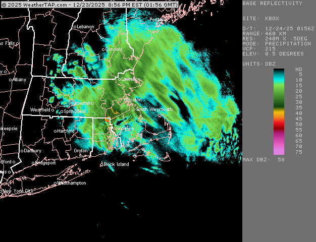
-
December 2025 regional war/obs/disco thread
WinterWolf replied to Torch Tiger's topic in New England
Mid Atlantic deal. -
Would be a bizarre outcome if it verified
-

Central PA Winter 25/26 Discussion and Obs
Mount Joy Snowman replied to MAG5035's topic in Upstate New York/Pennsylvania
Voyager, with all due respect, and I have empathy for what you’re going through, I really do, but this is a weather forum where the vast majority of us are rooting for winter weather in winter. The negative posts can be a bit much at times. I really hope you get to a better place sometime soon. -
Its final Nam has a weird orientation. Looks like a lake effect streamer .
-
From the Mammoth Mountain Ski Resort webpage Snow, mainly after 10pm. The snow could be heavy at times. Low around 25. Windy, with a southwest wind 30 to 35 mph, with gusts as high as 50 mph. Chance of precipitation is 100%. Total nighttime snow accumulation of 9 to 13 inches possible.
-
one more jump like that and many will be happy.. hopefully the Icon holds and other move towards it
-

December 2025 regional war/obs/disco thread
TauntonBlizzard2013 replied to Torch Tiger's topic in New England
Yeah, meh -
still going here no?
-
Nam
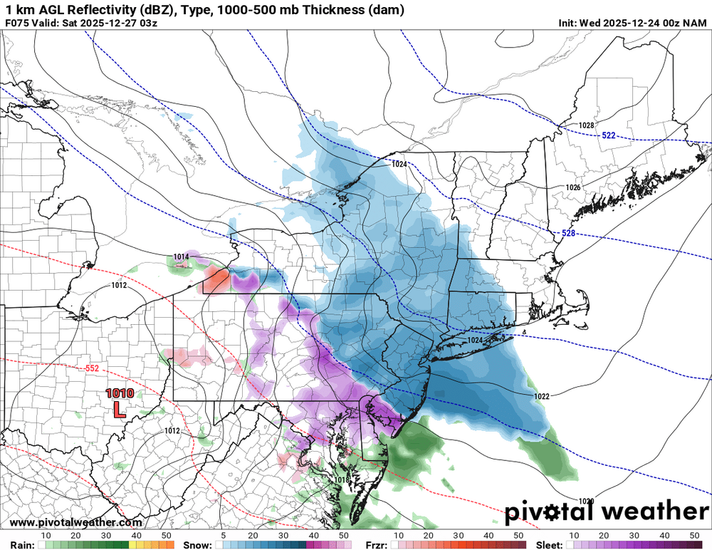
.thumb.png.e7f7426728f3d95456fa0623d9a9d16f.png)
-
Forky was cryptically bullish on the pattern when he chimed in a few days ago. Rjay outed him in the banter thread from the last snowfall.
-
Just made it
-
December 2025 regional war/obs/disco thread
WinterWolf replied to Torch Tiger's topic in New England
This. -
So we can make dick length jokes when it finally does snow?
-
If this threat continues, then maybe we can get some play by play tomorrow through Friday. Haven’t done any of that since the mid February 2024 region wide SECS. That was also the last winter storm warning in NYC. 3-6” in immediate NYC but a general 6-8+ regionwide. And before that, the last winter storm warning in NYC was for the 8-12” near blizzard on 1/29/22. Needless to say, it’s been a while since NYC has had a winter storm warning and we’ve been able to some play by play.
-
better but still south


.png.743fd7ec1b8bdf76a5f3da375c81a918.png)


