All Activity
- Past hour
-
Ever since The Climate Changer came in here talking about top 5 warmest May (circa 5/15) it has completely gone to shit. This is by far one of the more depressing stretches I can remember. Legit making me sad and angry. It's the weekends that are doing it to me.
-
Chilly out around 2am when dog was like "hey, I know your asleep and super tired but I gotta pee" Dreary afternoon with more showers to my west. So no grass cutting today. I'll just work on my model trains instead.
-
I do think there is something to this September being warmer than June idea, I wonder how many times that's happened in the past? So in 1983 September had 7 90 degree days including a 99 on 9/11, how many times has June had 7 90 degree days with a peak of 99 or higher?
-
But no 100 at LGA either? We can discount Central Park lol
-
That’s what happened at the end of June 2021. But the PACNW was much warmer with the historic heat there. Our area made it to the low 100s away from the immediate shore areas.
-
They just discovered a tick in CT with a new virus. I think it's the same tick that carries the virus that makes you sick when you eat meat. Report shows first evidence of longhorned tick infection in CT in recent years It's the first evidence of a longhorned tick with Ehrlichiosis in the entire country. https://www.nbcconnecticut.com/news/local/report-evidence-invasive-longhorned-tick-infection-ct/3573815/ Also those in CT can get ticks that bit them tested for free at The Connecticut Agricultural Experiment Station in New Haven. https://portal.ct.gov/caes/tick-office/tick-office/information-on-submitting-ticks
-
75 in Quebec City, 62 and mist here. Awful
-
March and April were very dry last year and the same this year. May was slightly wetter than normal last year at 3.73" and well above the normal of 3.60" this year with 5.42". The GFS Extended and Euro Weeklies believe that June will be wet this year. Fingers crossed. 1.50" Friday thru Sunday noon was very nice.
-
That is the COOP which is missing several days of data. The airport is +2.9 for the month so far. They had a record high of 93° a few days ago. BDR also had a record high with the recent over the top warm up. Almanac for DANBURY MUNICIPAL AP, CT June 5, 2025 Daily Data Observed Normal Record Highest Record Lowest Max Temperature 93 75 93 in 2025 60 in 2009 Min Temperature 60 53 68 in 2010 42 in 1998 Climatological Data for DANBURY MUNICIPAL AP, CT - June 2025 Click column heading to sort ascending, click again to sort descending. Sum 632 433 - - 19 33 0.48 Average 79.0 54.1 66.6 2.9 - - - Normal 74.6 52.8 63.7 - 28 17 1.21 2025-06-01 64 48 56.0 -6.6 9 0 0.04 2025-06-02 71 44 57.5 -5.4 7 0 T 2025-06-03 80 44 62.0 -1.2 3 0 0.00 2025-06-04 85 51 68.0 4.4 0 3 0.00 2025-06-05 93 60 76.5 12.6 0 12 0.00 2025-06-06 86 67 76.5 12.3 0 12 T 2025-06-07 76 60 68.0 3.5 0 3 0.41 2025-06-08 77 59 68.0 3.2 0 3 0.03 2025-06-09 M M M M M M M 2025-06-10 M M M M M M M 2025-06-11 M M M M M M M 2025-06-12 M M M M M M M 2025-06-13 M M M M M M M 2025-06-14 M M M M M M M 2025-06-15 M M M M M M M 2025-06-16 M M M M M M M 2025-06-17 M M M M M M M 2025-06-18 M M M M M M M 2025-06-19 M M M M M M M 2025-06-20 M M M M M M M 2025-06-21 M M M M M M M 2025-06-22 M M M M M M M 2025-06-23 M M M M M M M 2025-06-24 M M M M M M M 2025-06-25 M M M M M M M 2025-06-26 M M M M M M M 2025-06-27 M M M M M M M 2025-06-28 M M M M M M M 2025-06-29 M M M M M M M 2025-06-30 M M M M M M M RECORD EVENT REPORT NATIONAL WEATHER SERVICE NEW YORK, NY 0436 PM EDT THU JUN 05 2025 ...RECORD HIGH TEMPERATURE SET AT IGOR I SIKORSKY MEMORIAL AIRPORT IN BRIDGEPORT, CT... A RECORD HIGH TEMPERATURE OF 87 DEGREES WAS SET AT BRIDGEPORT CT TODAY. THIS BREAKS THE OLD RECORD OF 86 DEGREES SET IN 1953. RECORDS GO BACK TO THE YEAR 1948 AT THIS CLIMATE STATION.
-
Good luck with that! I haven't seen a win in person since I had last had hair on my head.
-
drought reversal has played into that-fairly wet since mid May-remember around May 1st we were all begging for rain? Seems like a long time ago now.
-
As Norm Dvoskin would say; "Not A Sky In The Clouds" .
-
Wednesday and Thursday should be 80 with sun around ... just when it is important for everyone to be that way -
-
Today has better storm vibes, at least hit/miss. Sun, calm wind (I'll confirm during lunch), and humid. We have a decent track record with those variables.
-
Beautiful day.
-
this weather sucks. that is all thanks
-
I want what's outside for 8 months out of the year with 1 month of fall, 2 months of winter, and 1 month of spring.
-
As for those saying June has been above normal so far, there are many locations in our subforum that are reporting below average. Danbury is one such location posting an average temp of 65.1 degrees against a normal to date of 66.2. For the year Danbury is at 42.1 degrees against an average of 43. Very rare in our current climate to be 'below' average. This May/June has been very odd in that some areas are holding on to cloud cover more than others, especially our more mountainous terrain. I do think the back half of summer will be much warmer than average and our fall will once again be warmer and drier than normal as that would be in line with our "stuck" weather patterns we get.
-
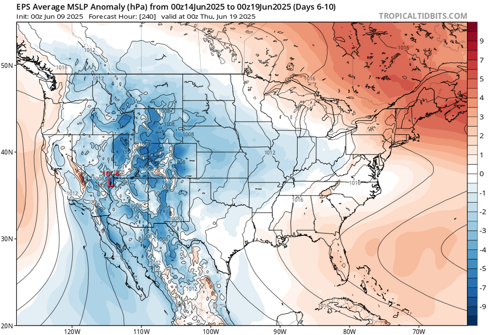
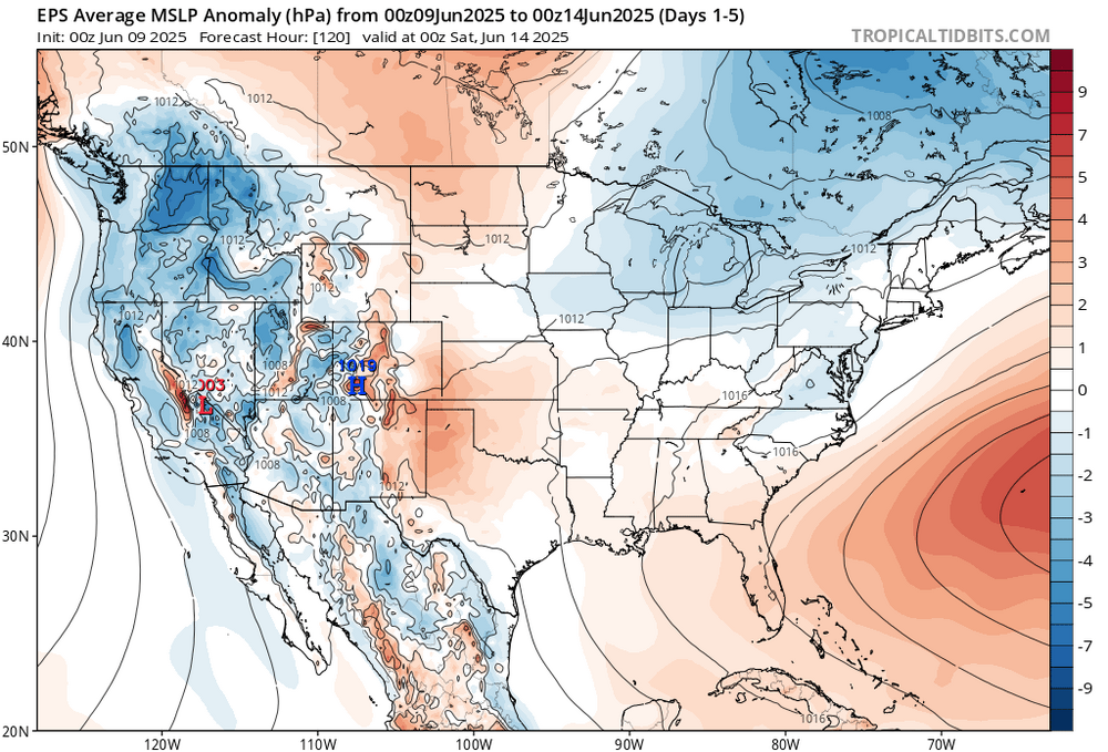
I wonder if we can bridge the two and get them to connect together to produce one giant High? All the heat is being funneled into the West.
-
The Bermuda High keeps dueling with the Canadian High. So this leads to the fronts stalling out near our area. You want one to dominate for extended sunny and dry weather.
-
I'm sure somewhere like Millville NJ or Wrightstown NJ will reach 30 90 degree days, Trenton NJ too.
-
Can you please explain why fronts keep *coming back* instead of just going west to east and passing offshore like they normally do, Tony?
-
Yeah, the early signal that the summer of 2022 would be the warmest in NJ since 2010 was the major upper 90s heat in May. This year the highs were around -10 cooler only reaching the upper 80s. I ageee that the best shot of going over 30 days this summer will be somewhere in NJ like recent summers. But not looking like a repeat of 2022 with 53 days reaching 90°. Someone in the state should reach 30° days this year. The last time the state wasn’t able to reach 30° days was way back in 2014. But we have warmed quite a bit since then. Monthly Data for May 2022 for New Jersey Click column heading to sort ascending, click again to sort descending. NEWARK LIBERTY INTL AP WBAN 98 TETERBORO AIRPORT WBAN 98 Newark Area ThreadEx 98 ESTELL MANOR COOP 96 HARRISON COOP 96 SOUTH JERSEY REGIONAL AIRPORT WBAN 96 ATLANTIC CITY INTL AP WBAN 95 INDIAN MILLS 2 W COOP 95 CALDWELL ESSEX COUNTY AP WBAN 95 AEROFLEX-ANDOVER AIRPORT WBAN 95 SOMERSET AIRPORT WBAN 95 Atlantic City Area ThreadEx 95 EB FORSYTHE NEW JERSEY RAWS 95 Monthly Data for May 2025 for New Jersey Click column heading to sort ascending, click again to sort descending. OCEAN COUNTY AIRPORT WBAN 89 NEWARK LIBERTY INTL AP WBAN 88 HARRISON COOP 88 Newark Area ThreadEx 88 CANOE BROOK COOP 87 TETERBORO AIRPORT WBAN 87 ESTELL MANOR COOP 87 TETERBORO AIRPORT COOP 87 HIGHTSTOWN 2 W COOP 86 NEW BRUNSWICK 3 SE COOP 86 CALDWELL ESSEX COUNTY AP WBAN 86 BELMAR FARMINGDALE ALLAIRE AP WBAN 86 SOMERSET AIRPORT WBAN 86 PHILADELPHIA/MT. HOLLY WFO COOP 86 SALEM COOP 86 New Brunswick Area ThreadEx 86 MILLVILLE MUNICIPAL AIRPORT WBAN 85 ATLANTIC CITY INTL AP WBAN 85 NJ #90 days during the 2020s Data for January 1, 2024 through December 31, 2024 Click column heading to sort ascending, click again to sort descending. HARRISON COOP 41 HIGHTSTOWN 2 W COOP 41 CANOE BROOK COOP 37 SOMERSET AIRPORT WBAN 35 Newark Area ThreadEx 33 NEWARK LIBERTY INTL AP WBAN 33 CALDWELL ESSEX COUNTY AP WBAN 33 TETERBORO AIRPORT WBAN 31 INDIAN MILLS 2 W COOP 31 PHILADELPHIA/MT. HOLLY WFO COOP 30 TETERBORO AIRPORT COOP 30 PENNSAUKEN 1N COOP 30 Data for January 1, 2023 through December 31, 2023 Click column heading to sort ascending, click again to sort descending. ESTELL MANOR COOP 34 HARRISON COOP 33 HIGHTSTOWN 2 W COOP 31 Newark Area ThreadEx 29 NEWARK LIBERTY INTL AP WBAN 29 Data for January 1, 2022 through December 31, 2022 Click column heading to sort ascending, click again to sort descending. SOUTH JERSEY REGIONAL AIRPORT WBAN 53 NEWARK LIBERTY INTL AP WBAN 49 Newark Area ThreadEx 49 HIGHTSTOWN 2 W COOP 49 CANOE BROOK COOP 47 SOMERSET AIRPORT WBAN 46 HARRISON COOP 44 New Brunswick Area ThreadEx 43 NEW BRUNSWICK 3 SE COOP 43 FREEHOLD-MARLBORO COOP 42 ESTELL MANOR COOP 41 INDIAN MILLS 2 W COOP 40 Data for January 1, 2021 through December 31, 2021 Click column heading to sort ascending, click again to sort descending. FREEHOLD-MARLBORO COOP 43 HIGHTSTOWN 2 W COOP 41 NEWARK LIBERTY INTL AP WBAN 41 Newark Area ThreadEx 41 HARRISON COOP 38 CALDWELL ESSEX COUNTY AP WBAN 37 NEW BRUNSWICK 3 SE COOP 36 SOUTH JERSEY REGIONAL AIRPORT WBAN 36 New Brunswick Area ThreadEx 36 SOMERSET AIRPORT WBAN 33 CANOE BROOK COOP 32 ESTELL MANOR COOP 31 PHILADELPHIA/MT. HOLLY WFO COOP 31 PENNSAUKEN 1N COOP 30 Data for January 1, 2020 through December 31, 2020 Click column heading to sort ascending, click again to sort descending. HIGHTSTOWN 2 W COOP 42 FREEHOLD-MARLBORO COOP 40 HARRISON COOP 39 CANOE BROOK COOP 37 CALDWELL ESSEX COUNTY AP WBAN 37 ESTELL MANOR COOP 36 HAMMONTON 1 NE COOP 32 ATLANTIC CITY INTL AP WBAN 31 NEWARK LIBERTY INTL AP WBAN 31 Atlantic City Area ThreadEx 31 Newark Area ThreadEx 31 NEW BRUNSWICK 3 SE COOP 30 FLEMINGTON 5 NNW COOP 30 New Brunswick Area ThreadEx 30
-
Yes it has, way too WET. also high mosquito populations. wet weather is NASTY for bugs!
-
Records: Highs: EWR: 102 (2011) NYC: 97 (1933) LGA: 99 (2008) JFK: 96 (1984) Lows: EWR: 47 (1957) NYC: 47 (1930) LGA: 59 (1980) JFK: 48 (1980) Histrical: 1874:The highest maximum temperature ever recorded in June in Washington, DC was 102 °F. (Ref. Washington Weather Records - KDCA) 1953 - A tornado hit the town of Worcester MA killing ninety persons. The northeastern states usually remain free of destructive tornadoes, however in this case a low pressure system, responsible for producing severe thunderstorms in Michigan and Ohio the previous day, brought severe weather to New Hampshire and central Massachusetts. The tornado, up to a mile in width at times, tracked 46 miles through Worcester County. It mangled steel towers built to withstand winds of 375 mph. Debris from the tornado fell in the Boston area, and adjacent Atlantic Ocea. (David Ludlum) (The Weather Channel) 1966: Hurricane Alma made landfall over the eastern Florida panhandle becoming the earliest hurricane to make landfall on the United States mainland. 1971: The tornado that struck the town of Gruver in the Texas Panhandle on this date is believed to be the widest tornado in U.S. history with an average path width of 2,500 yards. At times, the monster storm was over two miles wide. (Ref. Wilson Wx. History) what a historic day! It was 100+ for two days in a row at EWR in 2011 around this time? Regarding 1874, I didn't know DCA was recording temperatures that early! 1953 might have had the most historic day of all with that massive Worcester tornado and later that summer two historic heatwaves, our longest on record with 4 100+ days between them including one in September!! 1966 had our earliest hurricane landfall and another historic summer with both LGAs and JFKs highest temperatures on record (107 and 104). and 1971 with a tornado well over two miles wide!!


