All Activity
- Past hour
-
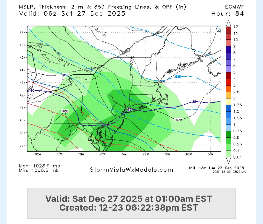
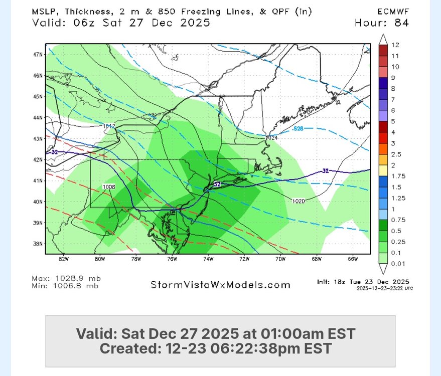
Euro better into like region with 1-3 or so. Going to be a strong CF close to BOS. May enhance the snow too.
-
(002).thumb.png.6e3d9d46bca5fe41aab7a74871dd8af8.png)
Boxing Night Snow/Sleet/Ice Dec 26-27 Storm Thread/Obs.
ChescoWx replied to Mikeymac5306's topic in Philadelphia Region
18z Euro trended much worse with more ZR less snow and less IP....this would be a not great solution! -

White Christmas Miracle? December 23-24th
Baroclinic Zone replied to Baroclinic Zone's topic in New England
What a farce this ended up being. Moving forward I’m going to take modeled QPF and divide by 10. I think about .01” has fallen here vs the .10+ that was modeled up till last night. -

December 2025 regional war/obs/disco thread
WxWatcher007 replied to Torch Tiger's topic in New England
-
Euro was weak… no sleet really and a few tenths of zr for the favored areas. Besides what the gfs is showing - this one might be cooked.
-

White Christmas Miracle? December 23-24th
CoastalWx replied to Baroclinic Zone's topic in New England
Good luck Mainers. Enjoy. -
Boxing Night Snow/Sleet/Ice Dec 26-27 Storm Thread/Obs.
ChescoWx replied to Mikeymac5306's topic in Philadelphia Region
I kind of see it that way 3" to 5" of snow/sleet and then freezing rain....not a big fan of ZR! -

Boxing Night Snow/Sleet/Ice Dec 26-27 Storm Thread/Obs.
MJO812 replied to Mikeymac5306's topic in Philadelphia Region
Euro is great
-
Euro looks better

-
Euro beefed up amounts
-
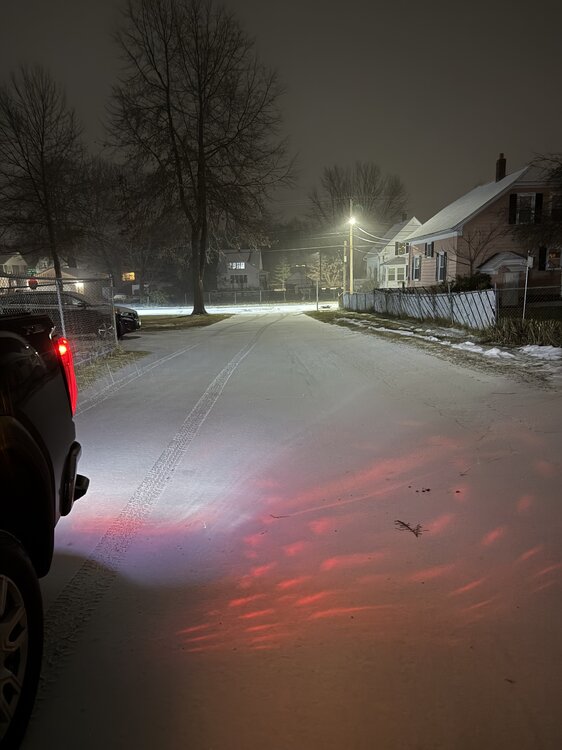
It was raining with a few mangled flakes. Now seems to be changing over to snow. I just want 1”
-

December 2025 regional war/obs/disco thread
Sey-Mour Snow replied to Torch Tiger's topic in New England
awesome snow tiger.. enjoy it.. -
that model blows. Better fix it.
-

Central PA Winter 25/26 Discussion and Obs
AccuChris replied to MAG5035's topic in Upstate New York/Pennsylvania
18z GFS kuchera snow and sleet for Friday . -

Snow Potential Dec 26-27
SomeguyfromTakomaPark replied to WeatherGeek2025's topic in New York City Metro
Looks really good for ny metro. -
We all want the ICON to be right about Friday/Saturday but it must be a worse model than I thought if even that isn’t bringing any hopium.
-
Because you have a wife and hes not on the receiving end
-
We needed that.
-

December 2025 regional war/obs/disco thread
Torch Tiger replied to Torch Tiger's topic in New England
Solid burst of snow, roads covered -

Boxing Night Snow/Sleet/Ice Dec 26-27 Storm Thread/Obs.
Kevin Reilly replied to Mikeymac5306's topic in Philadelphia Region
So, 3-5" of sleet then freezing rain Let's Go!! -
Darn it...
-
December 2025 regional war/obs/disco thread
Sey-Mour Snow replied to Torch Tiger's topic in New England
Man RRFS is the perfect replacement for the NAM, it jumps around just as much as it's drunk brother run to run .. Some of the radar hallucinations will be epic on Friday night .. FGEN bands crushing Syracuse headed right for SNE but wake up Saturday morning just to see it's still brown out .. -
Euro AI ticked north
-
It has that feel out of the gate when the street lights are like a curtain
-
I suspect there will be a convergence zone near the 28F isotherm in n/c NJ with enhanced totals similar to that event last winter (?) (or was it two winters back now?) ... 3 to 6 inches might be a good general forecast with this narrow band of 8 to 12 inches possibly somewhere like Long Branch - Sayreville-NB-Somerville NJ. That convergence zone would represent the southern boundary of unmodified arctic air, a second boundary further south would limit the mixed precip zone across parts of central NJ and e PA. That one would likely run through n DE and ne MD into the PA/MD border region. These two frontal zones would both likely stall for several hours then drift south near end of event, so mixing north of the strong convergence zone might be negligible.