All Activity
- Past hour
-

2025-2026 ENSO
Stormchaserchuck1 replied to 40/70 Benchmark's topic in Weather Forecasting and Discussion
Yeah, in the NAO roll-forward we would have to get -EPO to balance out those US Temps with such a strong +NAO going on. I just think it's cool how they pick their own unique landing place with the northern latitude trough, not in what's occurring or has occurred, but going forward. -
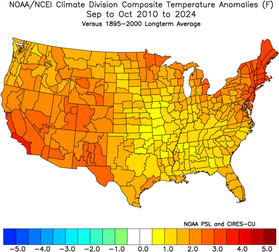
 2009 was the last time that we had both a cool September and October.
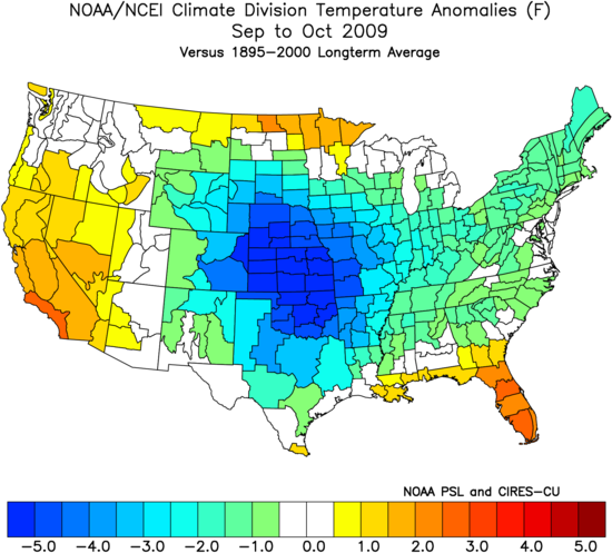
-
Lol, Aug-Nov doesn’t need to be anywhere near the most active ever to get 2025 to ~155 ACE and certainly wouldn’t even require close to 2005’s ACE the rest of the way, which was 179. We’re now at 2.5, which means 152.5 is needed to get to 155. 2005/1998/99/2017/2004/1961/1995 had 179/178/173/220/216/177/207 more ACE still to go. So, the most active since 1951 (2017’s 220, 2004’s 216, and 1995’s 207) would be 55-67 higher than the 152.5 needed this year to get to 155.
-

2025-2026 ENSO
40/70 Benchmark replied to 40/70 Benchmark's topic in Weather Forecasting and Discussion
This fits my early stuff precisely...+NAO with -EPO and some bouts of -AO. -
 84 / 64 more haze sun
 -
We;ll have to watch the wave(s) coming off Africa in the next week and with the expanding Atlantic ridge a west track towards the Caribbean the inland dev would be OTS like Dexter.
-
Light rain here.
-
2025-2026 ENSO
Stormchaserchuck1 replied to 40/70 Benchmark's topic in Weather Forecasting and Discussion
^They don't often go extreme though. A lot of it is the average error factored in. Compared to the N. Hemisphere, we are about in the middle of the warm anomaly. -
 looks like fish storms there
 -
Another earthquake in northern NJ. 2.7 this time.
-
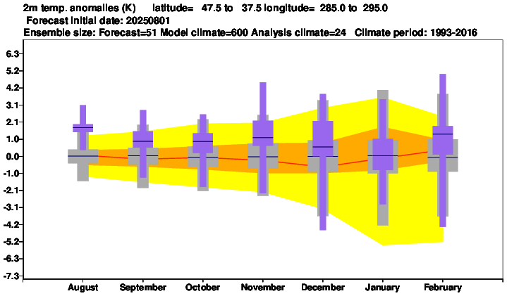
This is pretty much a broad brush from the Euro seasonal because it's NE US, but these monthly temp anomalies are not bad considering the last 10 years if close to being right.
-
^Here's how they roll-forward
-
Now all that said, you have to get the activity in the first place. The tropical Atlantic, while probably becoming more favorable in the coming days with the MJO change, still isn't a lock for high end activity. There's still work to do with instability. and this is the time of year where SAL still lurks But compared to prior years, this actually doesn't look bad
-
2025-2026 ENSO
Stormchaserchuck1 replied to 40/70 Benchmark's topic in Weather Forecasting and Discussion
It's very interesting! consistency usually dominates. This is the next three 7-month periods for the NAO, going to April 2026. US Temps aren't as warm as you would expect AO is completely different rolled forward - it's not a negative H5 based over Greenland, but over the Arctic circle and north of Alaska! -
https://x.com/RyanMaue/status/1952745028704420168
-
That's exactly it. If you had a more displaced jet you 1) open the door to more shear being imparted on a TC, which would lower potential and 2) more on point with this subject, you make it much harder for an "easy" recurve into the open Atlantic because the jet being displaced leads to the subtropical high being displaced--"blocking" a storm from easily recurving OTS depending on in-situ conditions (like is at TC following another into a weakness in Atlantic ridging). So think of it this way--there are always going to be weaker troughs/fronts that can serve as a kicker, but with a jet that is displaced so far to the north you get ridging that can steer waves further west into the Caribbean (where a landfall is all but guaranteed) or the southwest Atlantic, where a ridge could keep a wave/TC plowing west or a weaker trough/front could turn something north/northwest along the East Coast. This is part of the reason why this seems like more of an EC season, at least through the end of the month. The seasonal steering pattern has been highly favorable for US strikes, and the background environment with ENSO implies that this kind of predominant ridge/trough pattern could last into the peak of the season. (image below from Webb) I chose these time stamps for 10 days out, but this is an enormous signal for carrying anything that develops in the Atlantic west, provided it doesn't develop in the central Atlantic subtropics. That's why you see such a robust signal from the GFS/Euro operational guidance. There's a massive ridge and no currently modeled weaknesses to turn something OTS. If things got active in the Atlantic in the last 2/3 of August someone will be in trouble.
-
Very impressive storm for this time of year with such a strong +NAO vortex.
-
 Yes that’s the only one we felt personally here on LI. The basement door was shaking
 -
 Btw when it was in the 90s in October 2019 it felt hot as balls despite lower sun angle lol
 -
Forget the 80s, that's not what makes September a nice month. 70s for highs and lower dews is what makes a nice September. Extended summer is just more 70 degree dewpoints and crap weather as far as I'm concerned.
-
 Hurricane next week. Remember Irene and the earthquake a week before ?
 -

2025-2026 ENSO
brooklynwx99 replied to 40/70 Benchmark's topic in Weather Forecasting and Discussion
ECMWF seasonal is pretty close to what myself and some others are thinking... pretty solid tendency for -EPO early on with the TPV likely displaced into SE Canada at times. also a bit of a signal for blocking early on, too? wouldn't be shocking with the -QBO sure, it likely ends up 1-2F AN, but nothing prohibitive, and there will be spells where the pattern is actually conducive for snowfall. i'll take it -
 Global warming?
 -
yeah it was cool, here's a neat moon shot video from last night https://www.foxsports.com/watch/fmc-9drb0dd9yytveey9


