All Activity
- Past hour
-
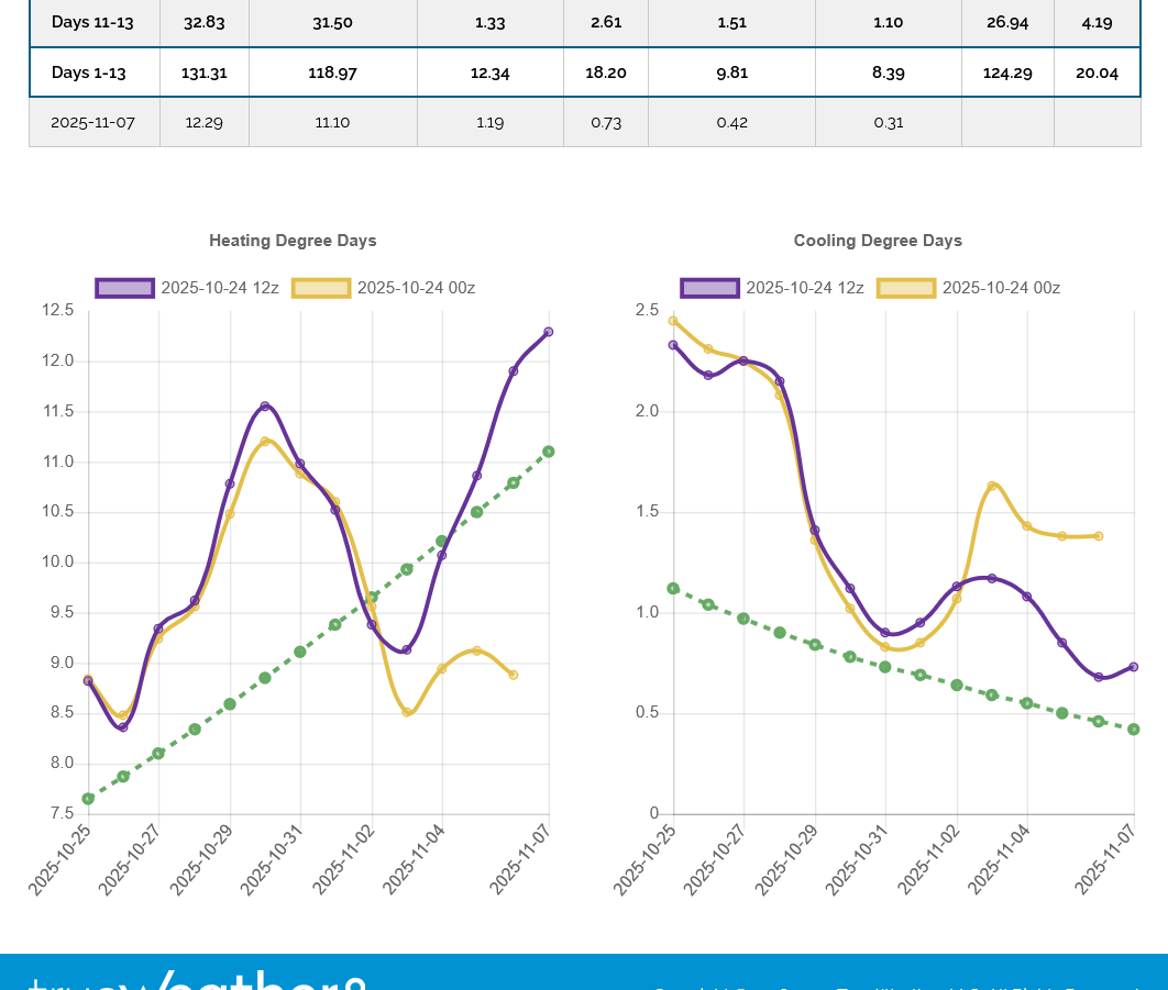
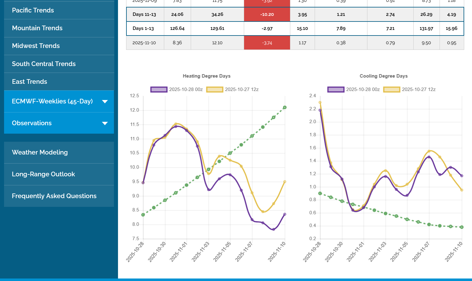
NG was down 4% today on warmer two week ensemble progs vs how they looked just a few days ago, which is consistent with the warmer 11/3-11 on the Euro Weeklies the last 2 runs. Check this comparison of EPS runs: Look how chilly the 10/24 12Z run was (purple on left): 11-12+ HDD 11/5-7 and pointing even higher (colder due to more HDDs): The 10/28 0Z run (purple) instead of pointing up/colder points down/warmer with only 8-10 HDDs 11/5-7 vs the 11–12+ of the 10/24 12Z run and then with additional days (11/8-10) also being quite mild with only ~8-8.5 HDDs meaning significantly lower NG demand in week 2 (despite week 1 still looking cold) than what the EPS was showing recently:

-
Yup, as I said earlier, I will finally get a new outdoor thermometer at my new apartment here next month, but I know when there's thermal inversion, as has been the case of late, we at the elevation of the river are always a few degrees colder than the local NWS station, KEEN. The past few mornings have been around 25F in Keene, about 200 feet ASL. We are at about 300 feet ASL, so been probably more like 22F. Suffice to say, it has been chilly!
-

Central PA Fall Discussions and Obs
Jns2183 replied to ChescoWx's topic in Upstate New York/Pennsylvania
WGAL is calling for a band of extremely heavy rain to setup like a firehouse se to nw over Harrisburg giving Harrisburg 2.60" Sent from my SM-X210 using Tapatalk -

Spooky Season (October Disco Thread)
Baroclinic Zone replied to Prismshine Productions's topic in New England
Crap day here. Socked in the clouds, windy, and some drizzle off and on. No sun whatsoever. -

Major Hurricane Melissa - 892mb - 185mph at landfall
Interstate replied to GaWx's topic in Tropical Headquarters
Yep... starting to look good again and wrapping back up. -

Major Hurricane Melissa - 892mb - 185mph at landfall
TheDreamTraveler replied to GaWx's topic in Tropical Headquarters
From what I've seen on Twitter this is apparently AI. -
Yeah. Refs seem like they been leaning the Chiefs way in last few games
-

Major Hurricane Melissa - 892mb - 185mph at landfall
Hotair replied to GaWx's topic in Tropical Headquarters
Black River hospital Jamaica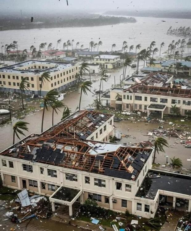
-

Major Hurricane Melissa - 892mb - 185mph at landfall
NJwx85 replied to GaWx's topic in Tropical Headquarters
The motion looks almost Easterly right now. That would prolong time over water. The core appears to be mostly intact, at least based on IR. -
President day storm no.1 I believe (Feb 1979)
-
True!! Their back up QB isn't the answer
-
Well I got a good wife now but first wife was having a bit more sex then me.. that was an issue
-

Major Hurricane Melissa - 892mb - 185mph at landfall
WxWatcher007 replied to GaWx's topic in Tropical Headquarters
Second recon flight in the air too now. -

Major Hurricane Melissa - 892mb - 185mph at landfall
Wannabehippie replied to GaWx's topic in Tropical Headquarters
Not a surprise given how high some of those mountains are in Jamaica. They do a number on any tropical system. But the eye is about to hit the water again, so time will tell if if re-strengthens once it hits the bathwater temps north of Jamaica -
*Taps the signature.*
-

Major Hurricane Melissa - 892mb - 185mph at landfall
GaWx replied to GaWx's topic in Tropical Headquarters
That’s what I was referring to earlier regarding catastrophic flash flooding coming off the mountains. Jeff P. on his live feed first alerted me to this. I greatly fear the casualties this may cause. I hope it’s not anything like Mitch, which had a death toll of 11-18K mainly due to this. -

Major Hurricane Melissa - 892mb - 185mph at landfall
klw replied to GaWx's topic in Tropical Headquarters
Looks like storms are firing on the east side of the core again. https://www.meteo.psu.edu/ewall/PSUGOES_MESO1/loop90.html -
This Storm would have produced Major Snow in part's of our Area a Month later.
-
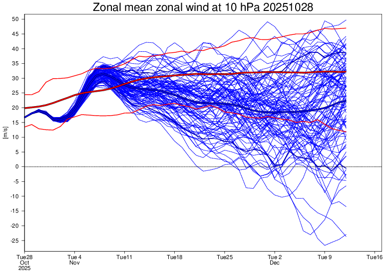
1. Since my last post on E US temperatures on the Euro Weeklies two days ago, they’ve warmed up significantly in just about all of the weeks. Not only is Nov 3-9 not nearly as chilly, but also Nov 10-30 has warmed from mainly NN to pretty solid AN. So, it looks like we may not get the coldest 11/27-11/9 since 2012 after all. @snowman19will be happy 2. Despite that, the forecast for the SPV remains about as weak as it looked yesterday and with more members with a very early major SSW (~22-23%). IF that unlikely event were to occur then, that may help lead to a cold 2nd half of Dec. So, snowman may not be crazy about this
-
Yeah. Used to be higher percentage so, things does appear to have changed.
-

Major Hurricane Melissa - 892mb - 185mph at landfall
olafminesaw replied to GaWx's topic in Tropical Headquarters
https://x.com/volcaholic1/status/1983245789158642173 -
Major Hurricane Melissa - 892mb - 185mph at landfall
WxWatcher007 replied to GaWx's topic in Tropical Headquarters
Landfall expected around 2am. Not a ton of time to reorganize and intensify, but we’ll see what recon finds. -
Major Hurricane Melissa - 892mb - 185mph at landfall
GaWx replied to GaWx's topic in Tropical Headquarters
I haven’t but in the past in very strong storms, he’s gone many hours with no posts once a storm has hit. It may not be til tomorrow or later for the next post for all we know. - Today
-
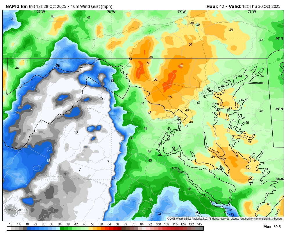
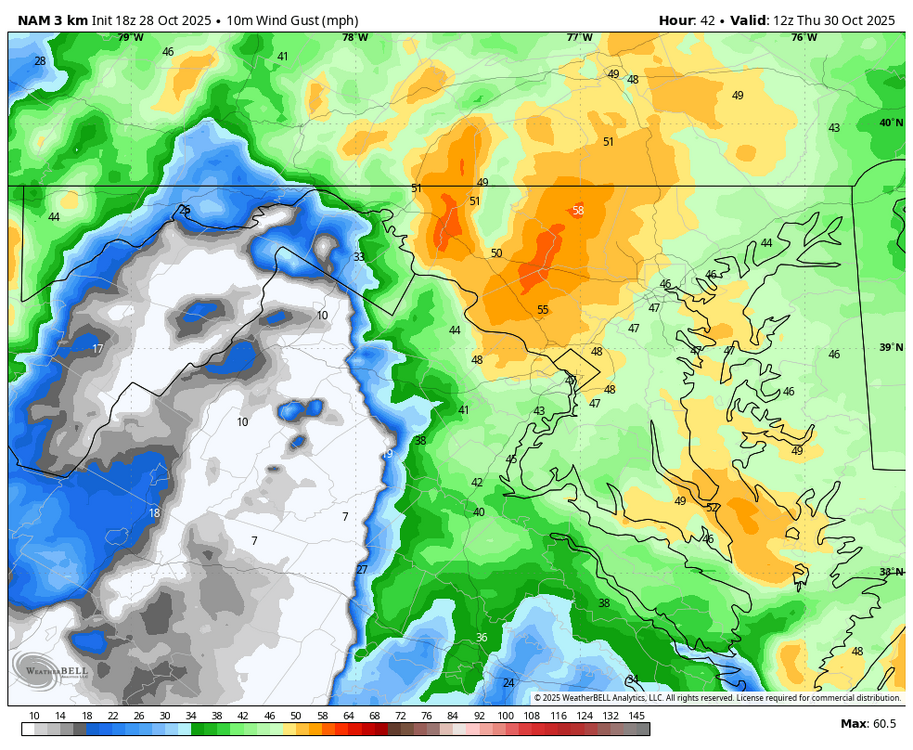
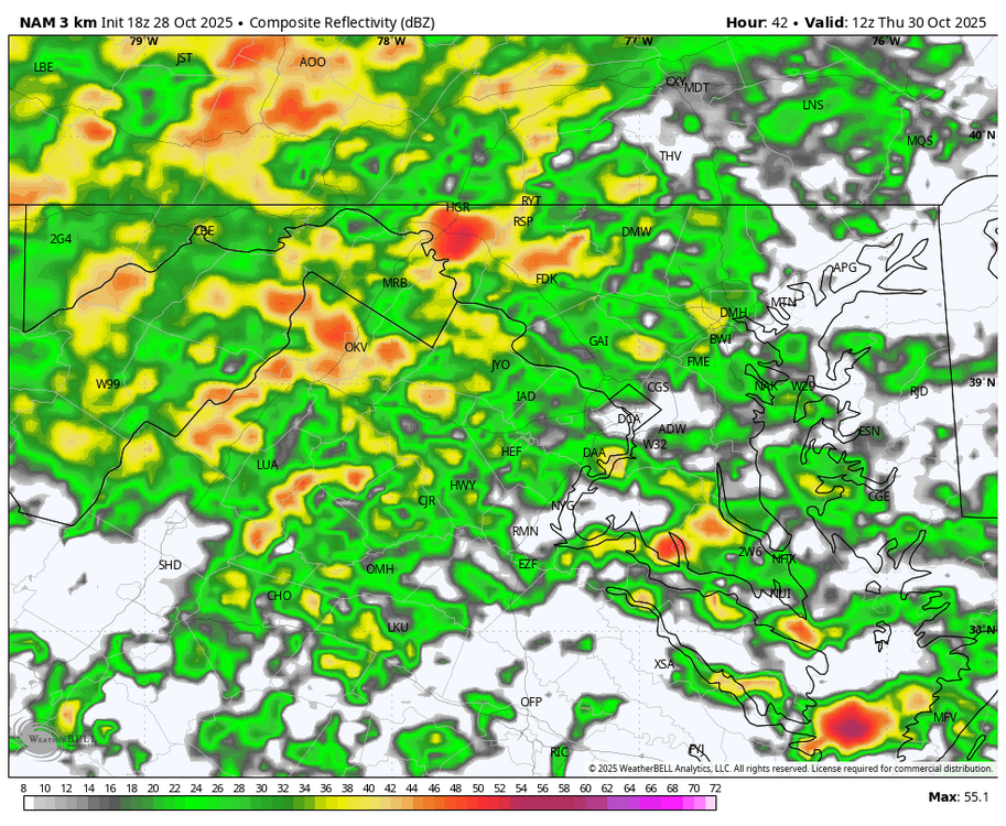
WB 18Z 3K NAM; windy and stormy Th. am on tap.
-
Major Hurricane Melissa - 892mb - 185mph at landfall
NJwx85 replied to GaWx's topic in Tropical Headquarters
Has anyone heard from Josh since LF? His last tweet was about 5 hrs ago before the worst hit.