All Activity
- Past hour
-
Good morning and thank you Liberty. My strength is still knowing how to use a calculator and being retired having plenty of time to use it. Stay well , as always …..
-
THIS!!! There is a very clear pattern that brings the storms up the coast to do damage. This is not even close to it.
-

Central PA Summer 2025
Mount Joy Snowman replied to Voyager's topic in Upstate New York/Pennsylvania
Low of 59. Today should mark 11 straight days of negative departures for MDT before things turn around for the foreseeable future tomorrow. Onward. -
I just don't get it. Why would you want to shed yourself in that light?
-
That was a spectacular weather weekend. Did whitewater tubing on Saturday at Harper's Ferry and I cannot imagine a better summer day for that. Two hikes with the dogs yesterday. Such deep blue skies, summer hot but not, HOT, humidity more than tolerable. Just a superlative set of weather days.
-

Central PA Summer 2025
TheClimateChanger replied to Voyager's topic in Upstate New York/Pennsylvania
Yes, those were noted in this thread. -
 74 / 66 mostly sunny and another beaut on the way. Upper 80s to low 90s perhaps a mid 90 in the hottest areas. Dryness leading to temps exceeding forecast in the sunshine. Warm - hot week overall with increasing humidity. Mainly low - mid 90s, perhaps the hootest areas get upper 90s 96/97 on Tuesday then again this weekend. Rain/showers Wed PM and Thu, lets see how much clouds get in the way of the 90s. Overall warm - hot throug the middle of next week. Beyond there ridge west and a cooler - near normal period before the Atlantic ridge brings warmer humid flow to close the month. 8/11 - 8/19 : Warm - Hot, more humid, rain limited to Wed Pm / Thu. Peak heat Tue, Sat/Sun 8/20 - 8/24 : Ridge west trough NE - near normal - Tropical activity to watch 8/25 - Beyond : Overall turning warm - hot / humid and wet
 -
He posts as if he represents the northeast and then picks Mt Pocono for verification. He is such a first class toolbag and an embarrassment.
-
hey nothing to complain at there
-

Invest 97L - NOW AT 90/90
BarryStantonGBP replied to BarryStantonGBP's topic in Tropical Headquarters
Top Category5Kaiju Category 5 Re: ATL: INVEST 97L - Discussion #108 Sun Aug 10, 2025 11:20 pm Just a quick reminder that this is happening in 25-26 C waters. This demonstrates that while important, raw sea surface temperatures are only one aspect of the picture when it comes down to maintaining a tropical cyclone. The June-July chatter about this season struggling with stability in August, Atlantic Nina, lukewarm tropical sea surface temperatures, etc. now feels like ancient history -
Invest 97L - NOW AT 90/90
BarryStantonGBP replied to BarryStantonGBP's topic in Tropical Headquarters
ropical Wave Re: ATL: INVEST 97L - Discussion #118 Mon Aug 11, 2025 6:00 am Flooding associated with this 97L disturbance caused six deaths tonight in São Vicente, Cape Verde. Four of the victims were children. Link 1 Link 2 -
Invest 97L - NOW AT 90/90
BarryStantonGBP replied to BarryStantonGBP's topic in Tropical Headquarters
-
North Atlantic blob (10/10)
BarryStantonGBP replied to BarryStantonGBP's topic in Tropical Headquarters

-
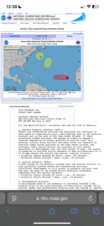
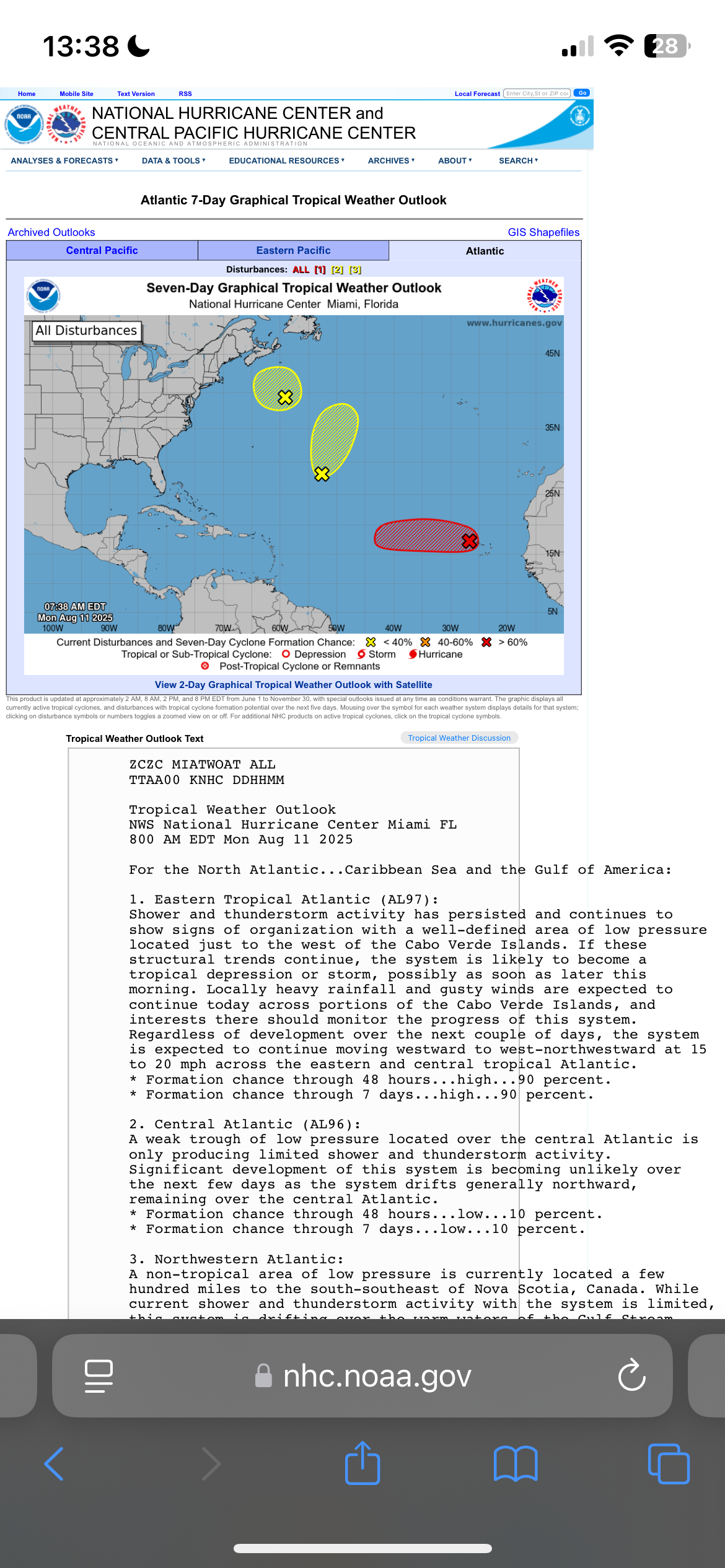
3. Northwestern Atlantic: A non-tropical area of low pressure is currently located a few hundred miles to the south-southeast of Nova Scotia, Canada. While current shower and thunderstorm activity with the system is limited, this system is drifting over the warm waters of the Gulf Stream where some tropical or subtropical development could occur over the next day or two. By the middle of this week, the system is expected to move northward over cooler waters, ending its changes for further tropical development. * Formation chance through 48 hours...low...10 percent. * Formation chance through 7 days...low...10 percent.
-
I see that same weenie map every season. Worst of winter is right. 33 degrees and rain lol
-
Could you imagine
-
I'd love to see it! Would make for some fun comments.
-
Glad to have you on board!
-
Then this was in the forecast discussion this morning: AREA FORECAST DISCUSSION NATIONAL WEATHER SERVICE CHARLESTON SC 612 AM EDT MON AUG 11 2025 SYNOPSIS A STATIONARY FRONT TO THE SOUTH OF THE REGION SHOULD DISSIPATE TODAY. BY MID TO LATE WEEK, SURFACE HIGH PRESSURE WILL SHIFT INTO THE ATLANTIC, WHILE WEAK TROUGHING FORMS INLAND. NEAR TERM /THROUGH TONIGHT/ THE UPPER-LEVEL ANTICYCLONE THAT HAS BEEN POSITIONED WELL OFFSHORE OF THE SOUTHEAST U.S. FOR THE PAST SEVERAL DAYS WILL BEGIN TO BUILD WEST TODAY AND REPLACE THE MID-LEVEL WEAKNESS THAT HAS BEEN IN PLACE SINCE LAST FRIDAY. THE ATMOSPHERE WILL REMAIN MODESTLY UNSTABLE THROUGH THE AFTERNOON WITH A PLUME RICH, TROPICAL MOISTURE FEATURING PWATS HOLDING IN THE 2.30-2.65". SIMILAR TO THE PAST FEW DAYS, PASSING BITS OF VORTICITY PROPAGATING ALONG THE WESTERN PERIPHERY OF THE UPPER HIGH WILL BRING SEVERAL MORE BANDS/WAVES TO SHOWERS/TSTMS TO THE AREA. and THE HIGHEST RAIN TOTALS SINCE FRIDAY HAVE BEEN MOSTLY CONFINED TO THE COASTAL COUNTIES WHICH SHOULD CONTINUE AGAIN TODAY. ***SOME AREAS HAVE SEEN AS MUCH AS FOOT OF RAIN OVER THE PAST SEVERAL DAYS ALONE WHICH IS DOWNRIGHT INCREDIBLE FOR AUGUST OUTSIDE OF A TROPICAL CYCLONE.*** ————— I had been up to ~9.9” month to date through the period just before the rains returned at 11:30 PM last night. I don’t yet have my overnight total, but it was significant once again, quite possibly ~2”. I’ll update later.
-
Followup: It turned out that several bands of rain, sometimes moderate or heavy, continued to come in from the SE over this area. There was heavy near and soon after midnight. And then while I was sleeping, this occurred, still another FF warning for still another band of heavy:BULLETIN - EAS ACTIVATION REQUESTED FLASH FLOOD WARNING NATIONAL WEATHER SERVICE CHARLESTON SC 156 AM EDT MON AUG 11 2025 THE NATIONAL WEATHER SERVICE IN CHARLESTON HAS ISSUED A * FLASH FLOOD WARNING FOR... CHATHAM COUNTY IN SOUTHEASTERN GEORGIA... JASPER COUNTY IN SOUTHEASTERN SOUTH CAROLINA... * UNTIL 400 AM EDT. * AT 156 AM EDT, DOPPLER RADAR INDICATED AN LARGE BAND OF SHOWERS AND THUNDERSTORM WITH TORRENTIAL RAINFALL JUST OFF THE COAST OF CHATHAM COUNTY. THIS BAND WILL MOVE ACROSS MUCH CHATHAM COUNTY INTO PARTS OF JASPER COUNTY THROUGH 4 AM. THIS INCLUDES MUCH OF THE SAVANNAH METRO AREA. AS MUCH AS 1 TO 3 INCHES OF RAIN COULD FALL OVER A VERY SHORT PERIOD. THIS WILL RESULT IN URBAN FLOODING AND FLASH FLOODING. ROAD CLOSURES ARE POSSIBLE, ESPECIALLY ACROSS DOWNTOWN SAVANNAH. HAZARD...FLASH FLOODING CAUSED BY THUNDERSTORMS. SOURCE...RADAR INDICATED. IMPACT...FLASH FLOODING OF SMALL CREEKS AND STREAMS, URBAN AREAS, HIGHWAYS, STREETS AND UNDERPASSES AS WELL AS OTHER POOR DRAINAGE AND LOW-LYING AREAS. * SOME LOCATIONS THAT WILL EXPERIENCE FLASH FLOODING INCLUDE... POOLER, BLUFFTON, TYBEE ISLAND, MIDTOWN SAVANNAH, DOWNTOWN SAVANNAH, HUTCHINSON ISLAND, HUNTER ARMY AIRFIELD, WINDSOR FOREST, WILMINGTON ISLAND AND COFFEE BLUFF.————————Then this statement was issued:CHATHAM GA-JASPER SC- 326 AM EDT MON AUG 11 2025 ...FLASH FLOOD WARNING REMAINS IN EFFECT UNTIL 4 AM EDT EARLY THIS MORNING FOR CHATHAM AND JASPER COUNTIES... AT 326 AM EDT, DOPPLER RADAR INDICATED MODERATE TO LOCALLY HEAVY RAIN FALLING OVER MUCH OF CHATHAM COUNTY. WHILE THE MOST INTENSE RAIN HAS SHIFTED NORTH OF THE AREA, THE RISK FOR FLOODING CONTINUES. AS MUCH AS 1 TO 2.5 INCHES OF RAIN HAS FALLEN IN SOME AREAS SINCE 2 AM. HAZARD...FLASH FLOODING CAUSED BY THUNDERSTORMS. SOURCE...RADAR INDICATED. IMPACT...FLASH FLOODING OF SMALL CREEKS AND STREAMS, URBAN AREAS, HIGHWAYS, STREETS AND UNDERPASSES AS WELL AS OTHER POOR DRAINAGE AND LOW-LYING AREAS. SOME LOCATIONS THAT WILL EXPERIENCE FLASH FLOODING INCLUDE... POOLER, BLUFFTON, TYBEE ISLAND, MIDTOWN SAVANNAH, DOWNTOWN SAVANNAH, HUTCHINSON ISLAND, HUNTER ARMY AIRFIELD, WINDSOR FOREST, WILMINGTON ISLAND AND COFFEE BLUFF.
-
I’ve never seen a summer in W MA with so little thunder.
-
Well AVP has a shot at 90 tomorrow but probably end up 88-89
-
Gonna’ be a fast foliage season if it doesn’t rain.
-
Mixing hgts are limited in these model runs, which is sort of shirking the heat potential some... I'm seeing like 925mb BL depths at 18z on the NAM. Standard adiabatic extrapolation can't get the 1000mb much past 30C if that's all. So... the 2-m are only 90..91. Yet, the 850 mb T's, the standard BL summer metric sigma height is up +18 or +19C, which if that were the adiabat we'd be talking 99 or 101. That's 10 F worth of shirk. Lol. The last heat of the season has the pedigree to be mid and upper 90s, yet the models are pancaking the mixing heights at max heating.
-
There is a very clear pattern that brings the storms up the coast to do damage. This is not even close to it. At worse it gets breezy conditions to Cape Cod maybe some showers at worst.


.thumb.png.4150b06c63a21f61052e47a612bf1818.png)

