All Activity
- Past hour
-
October 15th
-
 online canadian pharmacy and canadian pharmacy checker my canadian pharmacy http://fishingkuban.ru/forum/away.php?s=http://northrxcanada.com canada pharmacy store or http://www.servinord.com/phpBB2/profile.php?mode=viewprofile&u=806069 canadian pharmacies shipping to usa [url=https://maps.google.co.ug/url?sa=t&url=https://northrxcanada.com]online canadian pharmacy[/url] canadian pharmacies shipping to usa or [url=https://act2day.eu/profile/chzplcabby/]canadian mail order pharmacy[/url] best canadian pharmacy
 -
September 10 2002: A late-season tornado strikes Albertville just after midnight .According to a damage survey conducted by NWS personnel, it touched down on the eastern edge of Cedar Creek Golf Course, then it moved straight east and dissipated in a city park just west of the railroad tracks. It completely tore the roof off of one home. Roofs were partially off a number of other homes, many attached garages collapsed, and a couple of houses were rotated on their foundation. About 20 homes were damaged, nine of which sustained significant damage. 1986: 3 inch hail falls in Watonwan County. 1947: Downpours fall across the Iron Range. Hibbing receives 8.6 inches in three hours. 1931: St Cloud experiences a record high of 106 degrees, and it reaches 104 degrees in Minneapolis. 1910: The shortest growing season on record in Duluth ends, with frost free days from June 14 to September 10 (87 days). Normally the frost-free season is 143 days. For Thursday, September 10, 2026 1919 - A hurricane struck the Florida Keys drowning more than 500 persons. (David Ludlum) 1960 - Hurricane Donna struck the Florida Keys, with winds gusting to 180 mph and a thirteen foot storm surge. The hurricane then moved north along the eastern coast of Florida and inundated Naples before moving out to sea. Hurricane Donna claimed fifty lives, injured 1800 others, and caused more than 300 million dollars damage. The Marathon/Tavernier area was almost completely destroyed, and in the Citrus Belt, most of the avacado crop was blown from the trees. Hurricane Donna wreaked havoc from Florida to Maine, with wind gusts to 100 mph along much of the coast. Hurricane Donna produced wind gusts to 121 mph at Charleston SC on the 11th, and wind gusts to 138 mph at Blue Hill Observatory MA on the 12th. The hurricane finally died over Maine two days later, producing more than five inches of rain over the state. (David Ludlum) (The Weather Channel) 1987 - A late afternoon thunderstorm roared through Austin TX producing wind gusts to 81 mph, and 2.17 inches of rain in just sixty minutes. The high winds toppled six National Guard helicopters at the Robert Mueller Municipal Airport, and damaged or destroyed numerous other aircraft. (Storm Data) (The National Weather Summary) 1988 - Cool air sweeping into the north central U.S. brought snow to some of the higher elevations of Montana. The town of Kings Hill, southeast of Great Falls, was blanketed with six inches of snow. Tropical Storm Gilbert strengthened to a hurricane over the eastern Caribbean. (The National Weather Summary) (Storm Data) 1989 - Light snow fell in Montana overnight, with three inches reported at Fairfield. Billings MT reported a record low of 33 degrees. Unseasonably warm weather prevailed in the northeastern U.S., with record highs of 86 degrees at Caribou ME and 90 degrees at Burlington VT. (The National Weather Summary) (Storm Data) Observances: 10 Thu National School Picture Day 10 Thu National Swap Ideas Day 10 Thu International Makeup Day 10 Thu World Suicide Prevention Day 10 Thu National Anti-Junk Light Day 10 Thu National TV Dinner Day 10 Thu Swap Ideas Day 10 Thu World Top Up Day
-

2026-2027 Record-breaking El Nino
mitchnick replied to Stormchaserchuck1's topic in Weather Forecasting and Discussion
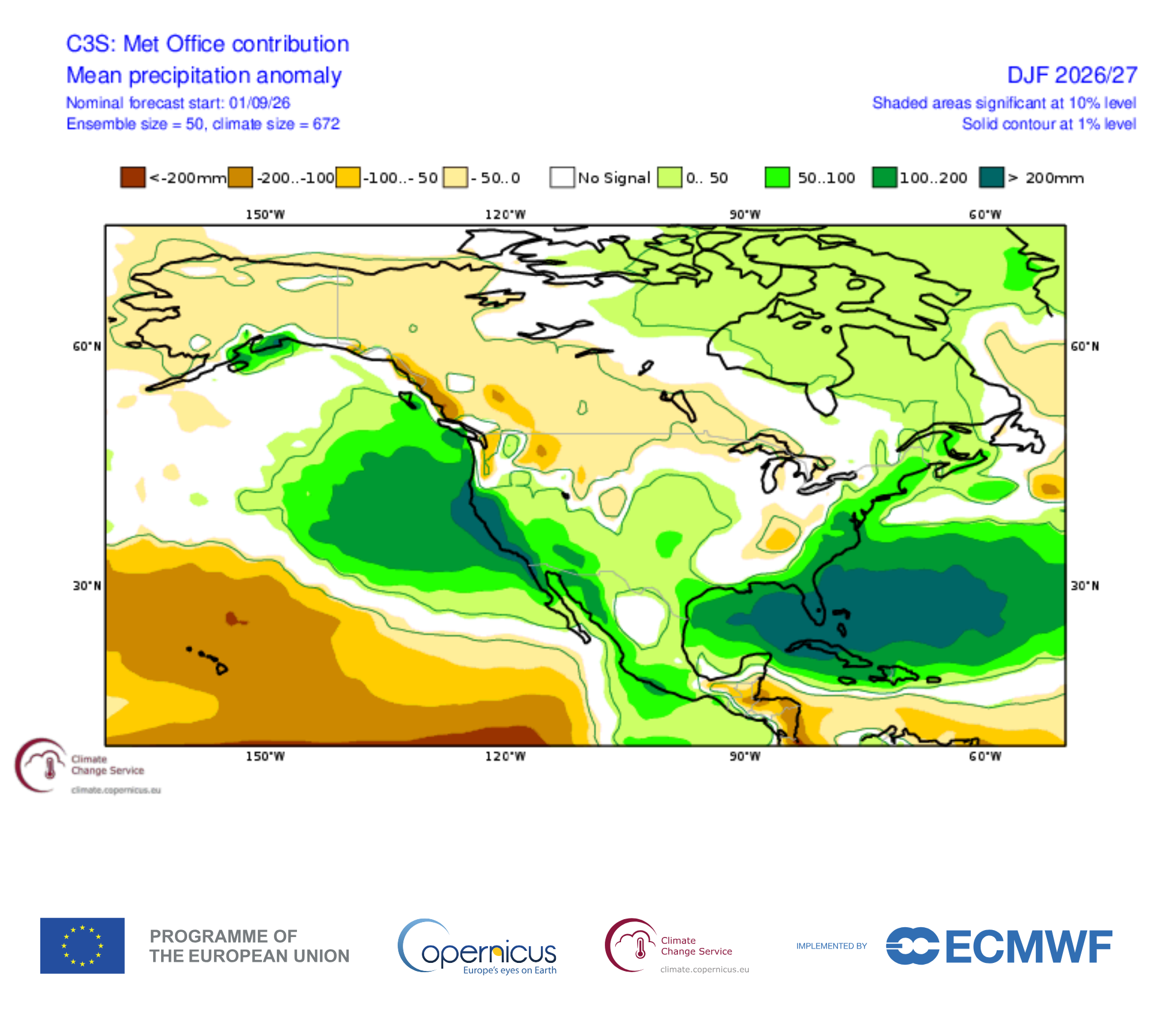
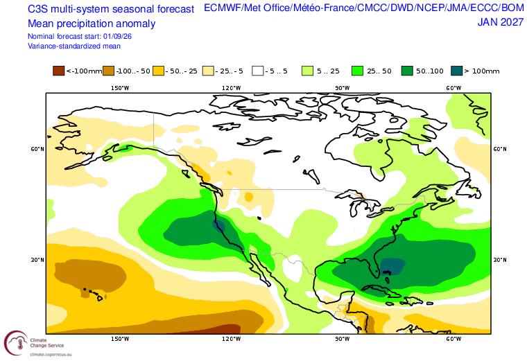
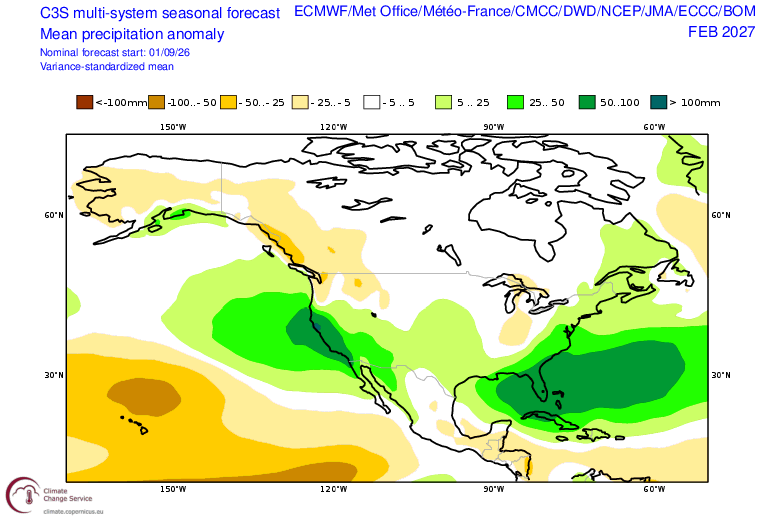
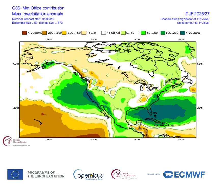
Monthly precip DJF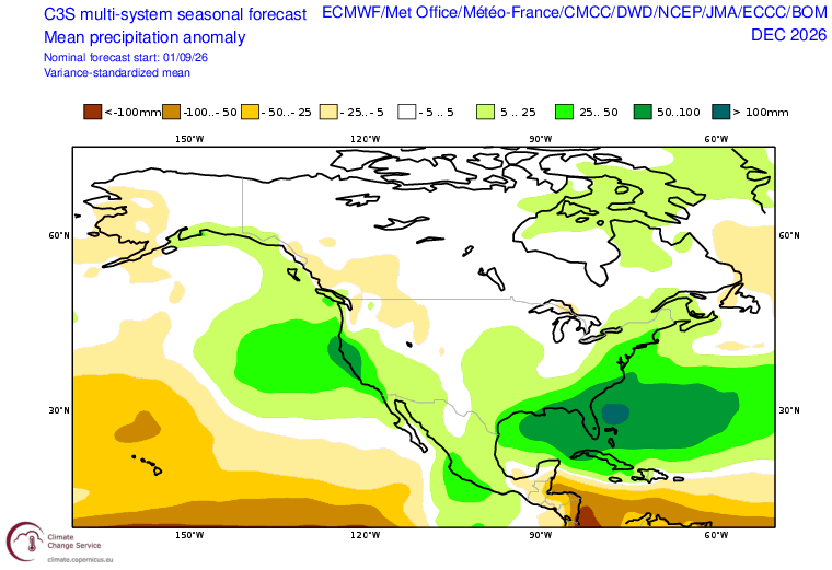
-
One aspect that lurks that I'd be careful to mention is that single event results tend to exceed QPF at an observably increasing frequency over recent decades ... I feel this needs to be a bullet point in seasonal forecasting summaries. Don't linger on it per se. Just a mention is needed. this is already papered/correlated to increased ambient WV in the overall machinery of the planet. There appears to be a synergistic phenomenology - handsome words to say that when we are raining or snowing or sleeting or hailing or whatever, when doing so through higher WV mass, favors "positive busts" The models seem to be physically challenged in this area, too - although I don't mean to claim that is true. Just that I keep seeing real events where 30" of rain in 24 hours falls and models might have had an "eye-popping" foot of rain as it is. Heh, it is almost as though eye-popping = an GOATie uh oh'er I was just thinking that in a year that may be a shitty wet warm one, a single snower could be something truly short duration historic. Like shock and awe given that scale/degree of ENSO plausibly feeding two source of WV+, the ENSO itself, together with the ambient argument. That's like synergy, then synergizing yet further, in a single event that happened to roll a 7 cold enough airmass at the right time. A couple of storms like this and we have an average snow year ...when the real story ends up being the flooding next March. LOL 63" of blue snow at ORH and National Guard only reserved for Science Fiction, right? I mean that's rhetoric for fun there... but think back to December 23 1997. The day before that happened, the then 'ETA' ( grandfather to the soon-to-be made extinct blood lined NAM) model had something like .6" of total QPF at Logan, in a sounding that was -3 at 800, 0 and 900, and +2 mid way up the Pru' tower altitude. Very little or no QPF at ALB, which was colder... Now, the forecast was probably in error anyway. It was 1-3" of transparent glop for the Worcester Hills, to raining a cat paw or two down town Boston... I Emailed Harvey and thought that was too wet. I was not right enough! Because 20" of snow later, an amount the fell in 5 hours, pretty much herald in the era of choke snow deposition rates...These types of events have been occurring world over, too. Rain or snow, with increasing frequency since the late 1990s. That ENSO that year ... mm seems like a climo revolving door sometimes to me.
-

Septorcher 2026 Discussion - Endless Summer
Layman replied to Damage In Tolland's topic in New England
A soaking 0.15" here that should allow the lawn to continue to curl up and burn. We take.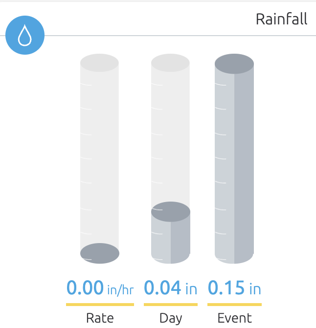
-
2026-2027 Record-breaking El Nino
mitchnick replied to Stormchaserchuck1's topic in Weather Forecasting and Discussion
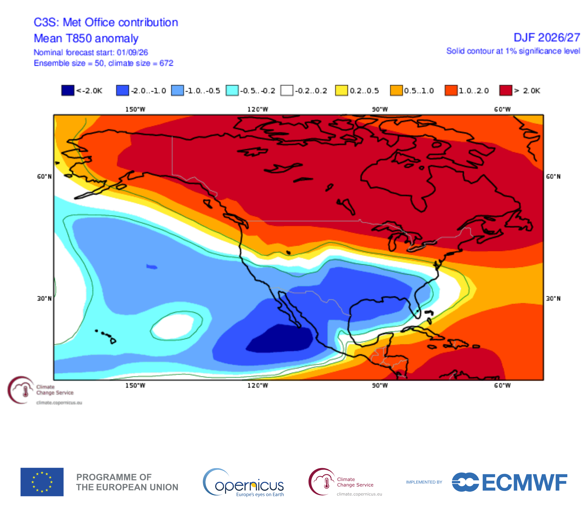
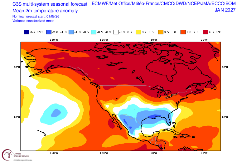
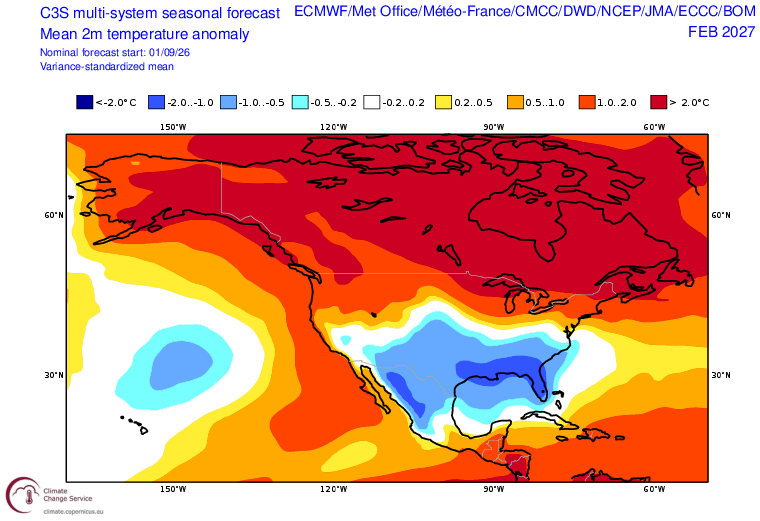
Monthly T2 DJF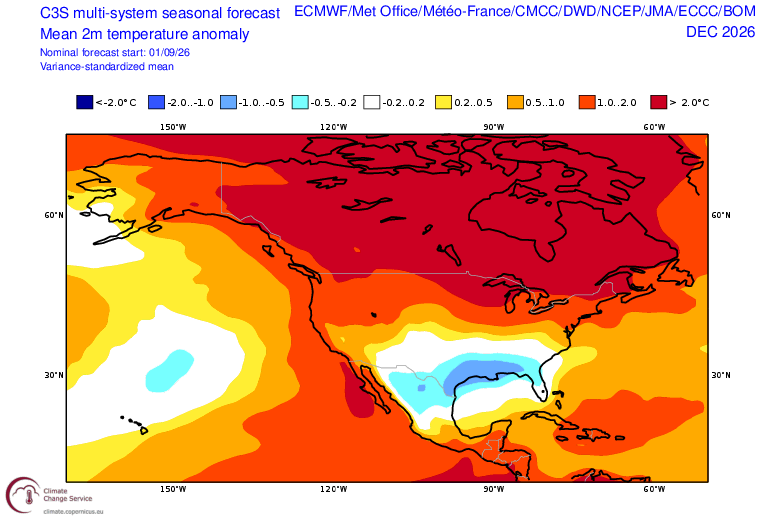
-

E PA/NJ/DE Autumn 2026 Obs/Discussion
JTA66 replied to PhiEaglesfan712's topic in Philadelphia Region
Bottomed out at 72F overnight -
Guess when your location will get its first measured snowfall, whoever is closest wins a 20$ Doordash or other restaurant card My guess: October 30th
-
Yeah, it's disturbing seeing all those ants. My guess is you'll see less and less each day. It's a good sign they found the bait and are taking it back to the nest. Good luck!
-
Upper 30's-40's across NE MN this morning. Starting to feel like Fall.
-

Central PA Summer 2026 Discussion/Obs Thread
paweather replied to Voyager's topic in Upstate New York/Pennsylvania
Thank you canderson I appreciate that so much. I’ll be here from time to time and more hopefully over the winter. I consider all of you as friends that are special to me. -

2026-2027 Record-breaking El Nino
40/70 Benchmark replied to Stormchaserchuck1's topic in Weather Forecasting and Discussion
I think we need to be careful here because the heat sink-oceans are changing the way we need to view the hemisphere when doing seasonal outlooks....there are some illusions taking place with regard to how 2023 appeared to mimic a Modoki configuration at the surface and was actually a La Nino-hybird, as this year maybe ostensibly an east-based deal acting more basin-wide as by product of all of that warmth tugging everything westward relative to expectation. -
I don't hate that map
-

2026-2027 Record-breaking El Nino
OSUmetstud replied to Stormchaserchuck1's topic in Weather Forecasting and Discussion
Congrats abq and houston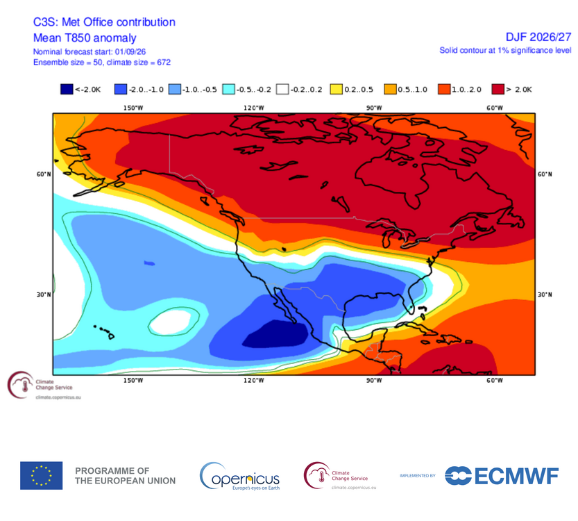
-
What is also interesting is that the EURO has trended stronger with the Canadian ridge centered near the east shore of HB, as the it adjusts to the unprecedented magnitude of El Nino, but the position of that Aleutian low remains dead-nuts on that of the August run. IOW, it hasn't trended into any more of an east-based configuration. This isn't what I would expect to see if you are looking for a season 6-month long fall.
-
have the beautiful weather dialed in, office normies loving it personally getting a little bored but i'll take it knowing a uk style winter is around the corner
-
Records: Highs: EWR: 98 (1983) NYC: 97 (1983) LGA: 95 (1983) JFK: 98 (1983) Lows: EWR: 44 (1938) NYC: 43 (1883) LGA: 50 (1978) JFK: 50 (1978) Historical: 1811: South Carolina was hit by a hurricane. The main highlight associated with the hurricane was a tornado that damaged downtown Charleston. 1900: South Dakota registered its maximum 24 hour precipitation record as 8.01 inches of rain fell at Elk Point, SD. (Ref. Wilson Wx. History) 1910: Duluth had the shortest growing season ever with frost free days from June 14 to September 10 (87days.) Normally the frost-free season is 143 days. (Ref. AccWeather Weather History) 1917: Duluth, MN saw its earliest freezing temperature reading with a record low of 31°. (Ref. Wilson Wx. History) 1919 - A hurricane struck the Florida Keys drowning more than 500 persons. (David Ludlum) 1944: Navy and Army Air Force B-24 Liberator planes flew into the "Great Atlantic Hurricane" from September 10th through the 15th. These were the first sanctioned military flights to obtain data on a hurricane. The data sent back was instrumental in helping hold the death toll from the destructive hurricane to 27 people. (Ref. Wilson Wx. History) 1947: Downpour across the Iron Range - Hibbing, MN got 8.6 inches in three hours. (Ref. AccWeather Weather History) 1960 - Hurricane Donna struck the Florida Keys, with winds gusting to 180 mph and a thirteen foot storm surge. The hurricane then moved north along the eastern coast of Florida and inundated Naples before moving out to sea. Hurricane Donna claimed fifty lives, injured 1800 others, and caused more than 300 million dollars damage. The Marathon/Tavernier area was almost completely destroyed, and in the Citrus Belt, most of the avacado crop was blown from the trees. Hurricane Donna wreaked havoc from Florida to Maine, with wind gusts to 100 mph along much of the coast. Hurricane Donna produced wind gusts to 121 mph at Charleston SC on the 11th, and wind gusts to 138 mph at Blue Hill Observatory MA on the 12th. The hurricane finally died over Maine two days later, producing more than five inches of rain over the state. (David Ludlum) (The Weather Channel) 1960: The center of Hurricane Donna passed over the middle of the Florida Keys between 2, and 3 am on this day. Donna was a Category 5 hurricane over the Atlantic and a Category 4 at landfall. This storm caused the deaths of over 100 in Puerto Rico, 50 in the United States, and 63 in a jet crash. The plane crash occurred on August 29th as a French airliner was attempting to land at Dakar, Senegal during a “blinding rainstorm.” The storm was likely a tropical disturbance at the time of the crash. 1961: On September 10th, the Television Infrared Observation Satellite observed an area of thunderstorms west-southwest of the Cape Verde Islands, suggesting a possible tropical cyclone. This storm is the first large tropical cyclone to be discovered on satellite imagery and would eventually become Hurricane Esther. 1965: After ravaging the Florida Keys on the 8th, Hurricane Betsy slammed in Louisiana with sustained winds of 125 to 130 mph and a minimum central pressure near 948 millibars or 28.00 inches of mercury. Houma, LA reported a wind gust of 130 mph. There were as many as 76 deaths and thousands injured. The storm surge and flooding from torrential rains caused an enormous amount of damage making this the greatest insured property loss in the U.S. up to this time. Betsy is known as first billion dollar hurricane with damage exceeding $1.4 billion dollars. (Ref. Wilson Wx. History) 1969: Birmingham, AL dipped to 49°; their earliest recorded temperature under 50°. Other record low temperatures included: Atlanta, GA: 49°, Tupelo, MS: 50°, Chattanooga, TN: 50°-Tied, Montgomery, AL: 52°, Meridian, MS: 52°-Tied, Macon, GA: 52°-Tied and Tallahassee, FL: 54°. (Ref. AccWeather Weather History) 1972: The Council Bluffs, Iowa area received wind damage and Shelby and Audobon Counties experienced a tornado. Rainfall totals in the three days from this date through the 12th were very impressive. Harlon, Iowa received 21 inches with 12.49 inches occurring on one day. Hundreds of families were left homeless from the flooding and losses of crops and buildings totaled nearly $20 million dollars. (Ref. Wilson Wx. History) 1976: Tropical Storm Kathleen moved northward from the Baja into the desert region of southern California; officially weakening to a depression just before crossing into the U.S. Yuma, AZ reported sustained winds of 57 mph, the highest on record associated with an eastern Pacific tropical cyclone in the southwestern U.S. A wall of water left a 700 foot wide, 40 feet deep gap at the Myer Creek Bridge on I-8 in Ocotillo, CA. The 4 to 6 foot high wall of water destroyed 70% of the homes. Daggett, CA received 2.28 inches of rain which was the greatest one day amount in recorded history. Overall, five people died and damage was estimated at $333 million dollars. (Ref. AccWeather Weather History) 1985: Late season heat wave ends in DC with seven straight 90° days. (Ref. Washington Weather Records - KDCA) 1987 - A late afternoon thunderstorm roared through Austin TX producing wind gusts to 81 mph, and 2.17 inches of rain in just sixty minutes. The high winds toppled six National Guard helicopters at the Robert Mueller Municipal Airport, and damaged or destroyed numerous other aircraft. (Storm Data) (The National Weather Summary) 1988 - Cool air sweeping into the north central U.S. brought snow to some of the higher elevations of Montana. The town of Kings Hill, southeast of Great Falls, was blanketed with six inches of snow. Tropical Storm Gilbert strenghtened to a hurricane over the eastern Carribean. (The National Weather Summary) (Storm Data) 1989 - Light snow fell in Montana overnight, with three inches reported at Fairfield. Billings MT reported a record low of 33 degrees. Unseasonably warm weather prevailed in the northeastern U.S., with record highs of 86 degrees at Caribou ME and 90 degrees at Burlington VT. (The National Weather Summary) (Storm Data) 1998: Tropical Storm Frances made landfall near Matagorda Bay, TX, causing the worst coastal flooding and beach erosion since Hurricane Carla in 1961. The storm's heavy rains ended a drought in East Texas but caused severe river flooding in parts of Texas and Louisiana. The highest rainfall total noted was 21.10 inches at Terrytown in southeast Louisiana. A major disaster declaration was issued for Cameron, Jefferson, Lafourche, and Terrebonne parishes in Louisiana. 1999: Straight line winds caused extensive damage at the Ardmore Industrial Park in Carter County, two miles northeast of Gene Autry, OK where a gust of 102 mph was measured. One aircraft hangar was completely destroyed and several were damaged. Several aircraft were overturned and three were destroyed. Damage was estimated at $2 million dollars. (Ref. Wilson Wx. History) 2008: Hurricane Ike emerged in the south-central Gulf of Mexico heading for the Texas coast with maximum sustained winds of 100 mph and a minimum central pressure of 27.91 inches of mercury. (Ref. Wilson Wx. History) 2009: Honolulu, Hawaii: Honolulu reports a record-tying high temperature of 92°F. (Ref. WxDoctor) 2017: Hurricane Irma crossed the Florida Keys as a Category 4 storm. 2018: Hurricane Florence was a powerful and long-lived Cape Verde hurricane, as well as the wettest tropical cyclone on record in the Carolinas and the ninth-wettest tropical cyclone to affect the contiguous United States. The sixth named storm, third hurricane, and the first major hurricane of the 2018 Atlantic hurricane season, Florence originated from a strong tropical wave that emerged off the west coast of Africa on August 30, 2018. Steady organization resulted in the formation of a tropical depression on the next day near Cape Verde. Progressing along a steady west-northwest trajectory, the system acquired tropical storm strength on September 1, and fluctuated in strength for several days over open ocean. An unexpected bout of rapid intensification ensued on September 4– 5, culminating with Florence becoming a Category 4 major hurricane on the Saffir–Simpson scale with estimated maximum sustained winds of 130 mph
-
72 / 69 clouds and scattered showers moving through the area. Warm more humid mid 80s to upper 80s and some stray 90 in spots. The period 9/10 - 9/17 overall warmer than normal warmest days today and the 16th-18th. Looking near normal beyond there.
-
That is an east-based El Nino with a basin-wide expression across the hemisphere on the EURO...no doubt. I think those expecting a season completely devoid of winter weather on the east coast are going to be in for a surprise if that model is correct.
-
2026-2027 Record-breaking El Nino
40/70 Benchmark replied to Stormchaserchuck1's topic in Weather Forecasting and Discussion
They should if they are incorporating real-time data. - Today
-
http://mexicogenerics.shop/# online mexico pharmacy
-
2026-2027 Record-breaking El Nino
40/70 Benchmark replied to Stormchaserchuck1's topic in Weather Forecasting and Discussion
That is an east-based El Nino with a basin-wide expression across the hemisphere on the EURO...no doubt. I think those expecting a season completely devoid of winter weather on the east coast are going to be in for a surprise if that model is correct. -
2026-2027 Record-breaking El Nino
OSUmetstud replied to Stormchaserchuck1's topic in Weather Forecasting and Discussion
Same charts show increases in Nino 3 and Nino 1.2 and decreases in Nino 4 compared to the early August forecasts. -
Cool, crisp upper 40's this morning with upper 60's this afternoon under sunny skies. A fairly average day for mid-sept. Trees are really beginning to turn quickly.