All Activity
- Past hour
-

2025-2026 ENSO
40/70 Benchmark replied to 40/70 Benchmark's topic in Weather Forecasting and Discussion
I think given (potentially) ENSO neutral this coming season, you have weight things towards modest cool ENSO. -
2025-2026 ENSO
40/70 Benchmark replied to 40/70 Benchmark's topic in Weather Forecasting and Discussion
We need to cool off the west Pac....or at least relative to the east Pac...the ratio right now (warmer west/cool east) predisposes us to a cool ENSO paradigm...that is why we have been having problems on the east coast due to se ridges and strong jets obliterating PNA ridges. That is cool ENSO like. I think we actually agree on alot, but just emphasize different aspects and drivers. -
Nothing is about to eat us…LOL. Most people off these forums like milder and less snowy winters. This is why most people are moving to the sunbelt instead of to the cooler and snowier spots like Marquette and Caribou. I point out the changes in the Pacific Jet for the very reason that I enjoy colder and snowier weather. So in order to understand how we could potentially change up this pattern is key for winter weather fans. We have to change the Pacific side and Southeast Ridge trends in order to bring back some great winter weather here. I grew up in the 70s and had to wait at the bus stop during those little ice age throwback winters. Also fond memories of the Great 1980s into early 1990s Arctic outbreaks. So I am more a fan of cooler climates than ones that have become much warmer. I have been trying to think how we could change up the Pacific in order to bring back more of a STJ influence. Would probably involve a very potent El Niño that would be very warm. But I am fine with winter warmth provided there are great snowstorms like in 15-16, 16-17, 17-18, and 20-21.
-
At least the sun is popping out here this morning.
-
2025-2026 ENSO
40/70 Benchmark replied to 40/70 Benchmark's topic in Weather Forecasting and Discussion
Man, @bluewave that link is an absolute pants tent.....you always casually pull these elite data sources out of your rear...too bad you never use your power for good, instead of in support of trying to convince us all that the Pacfic Jet is about to eat us. -
67th thankyouverymuchforyourintetestinthismatterpleasesendmoney
-
0.12 meh
-
As you Post from an air conditioned room all summer….
-
Dunno, for everyone in NNE it looks very showery and cloudy until Monday.
-
Yesterdays highs on Long Island Islip 67 Farmingdale 66 LaGaurdia 68 Kennedy 76
-
Ineedsnow will be trying to book a cabin up at Savoy SP.
-
Meanwhile 2-3” of rain and gusts 40-50 here and hrrr says congrats Mitch.
-
2025-2026 ENSO
40/70 Benchmark replied to 40/70 Benchmark's topic in Weather Forecasting and Discussion
The reality is that more often than not, there is a flaw in the pattern that will prevent a major snowstorm on the east coast...that is why averages are not higher. Its not always attributable to CC, but obviously that is becoming more of a factor. There are also times when nothing is ostensibly "wrong" with the pattern and it turns out that an act of god simply wasn't on the calendar....that can happen, too....this is why snowfall is subject to such a large degree of variance and is so difficult to predict. Mother nature is not bound by any of our rules...if she doesn't want to play ball, then she simply won't- Sometimes the reason why is apparent, other times not so much. -
2025-2026 ENSO
40/70 Benchmark replied to 40/70 Benchmark's topic in Weather Forecasting and Discussion
First of all, in the mean the WPO was very positive last season...that can't be dismissed. Secondly, the NAO was very positive througout February....thirdly, even during any brief instances during which the WPO and NAO were favorable, the PNA ridge was OFF of the west coast. Sorry, that wouldn't work in 1925, either. 2013-2014 had a vastly different Western Pacific...very +WPO. Now, that maybe linked to the strong Pac jet, so maybe we aren't in as stark disagreement as it may appear. PS: Thanks for the link! -
Yeah nonsense over later next week. Summer begins and the greatest time of year is upon us.
-
Not bad looking for here east of DC. Still nothing impressive. A few showers this morning and hopefully rain tonight.
-
Def need one of those some days. Cant have cake anymore because it can’t hold up under the weight of all the candles. It craters
-
Thank you!! I’m now at the point where I stop counting and anyone who tries to say my real age is fake news.
- Today
-
I’ve barely had the stove off. Euro finally starts warming it up after Monday. At least it torches info the following weekend.
-
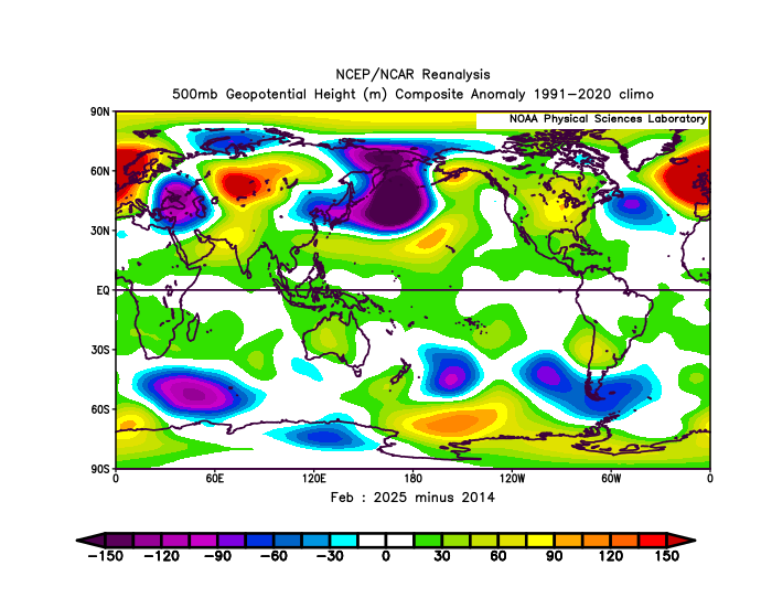
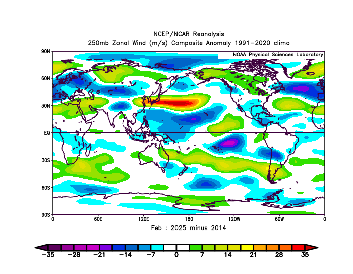
I agree with you that the 500 mb pattern in February was actually -PNA. But it was also -PNA in February 2014 with lower heights in the PNA region when we had around 30” inches of snow that month in NYC. The main difference was that the Southeast Ridge and Pacific Jet weren’t factors back in 2014 like they have become today. That big jet extension east of Japan coupled with a Southeast Ridge keeps the storm tracks through the Great Lakes.
-
Thursday? I turned pellet stove on yesterday and this morning
-
Happy birthday to @H2O!
-
Cold pool clouds and pop up convection for Saturday and pop up clouds on Sunday but not much actual rain.


.thumb.png.4150b06c63a21f61052e47a612bf1818.png)