All Activity
- Past hour
-

2025-2026 ENSO
KakashiHatake2000 replied to 40/70 Benchmark's topic in Weather Forecasting and Discussion
donsutherland1 wow amazing view -
I have to admit, I like to have a few of these days every summer. The caveat being, one has to be free to engage in some water based activity. If I had to be at the office, forget about it. I went paddling with the wife midday and happily took a dip, actually a few. Felt great of course. The only time I really swim is if it’s 90+.
-
Good point
-
Its on the doorstep.
-
046 WUUS51 KPHI 260106 SVRPHI DEC001-005-MDC011-035-041-260200- /O.NEW.KPHI.SV.W.0196.250726T0106Z-250726T0200Z/ BULLETIN - IMMEDIATE BROADCAST REQUESTED Severe Thunderstorm Warning National Weather Service Mount Holly NJ 906 PM EDT Fri Jul 25 2025 The National Weather Service in Mount Holly NJ has issued a * Severe Thunderstorm Warning for... Northwestern Sussex County in southern Delaware... Southwestern Kent County in central Delaware... Northeastern Talbot County in eastern Maryland... Central Queen Anne's County in northeastern Maryland... Caroline County in eastern Maryland... * Until 1000 PM EDT. * At 906 PM EDT, a severe thunderstorm was located over Oakland, or 9 miles southeast of Centerville, moving southeast at 25 mph. HAZARD...60 mph wind gusts. SOURCE...Radar indicated. IMPACT...Damage to roofs, siding, trees, and power lines is possible. * Locations impacted include... Centerville, Denton, Centreville, Harrington, Bridgeville, Greensboro, Oakland, Ridgely, Goldsboro, Queen Anne, Smithville, Starr, Jumptown, Griffin, Carville, Hope, Andrewsville, Agner, Greenwood, and Houston.
-

July 2025 Obs/Disco ... possible historic month for heat
CoastalWx replied to Typhoon Tip's topic in New England
Half inch at home today. We take the water. -

July 2025 Obs/Disco ... possible historic month for heat
Dan76 replied to Typhoon Tip's topic in New England
Killer here too -

July 2025 Obs/Disco ... possible historic month for heat
Torch Tiger replied to Typhoon Tip's topic in New England
Killer sunset, trash photographer lol.thumb.png.a16d8a50dd647a3022007667f566737b.png)
-
Yup, having a moderate shower here currently. Could have been better, as the earlier storm missed to the East.
-

Occasional Thoughts on Climate Change
Typhoon Tip replied to donsutherland1's topic in Climate Change
You can’t penetrate that individuals mind with logic. Them is impervious to objective reality -
Me too. Pathetic.
-

July 2025 Obs/Disco ... possible historic month for heat
Modfan2 replied to Typhoon Tip's topic in New England
Brush fire threat? lol -
Complete miss at home
-
Here is what the "doomers" actually say. Of the 366 simulations only 9 (or 2%) showed an ice-free state before 2030. Of the 366 simulations only 34 (or 10%) showed an ice-free state within 10 years. The median/median timing of the first ice-free state is 24/29 years. This puts the 2σ right tail at about 61 years or the year 2084. We have a LONG way to go (61 years) before we can declare this "doomer" prediction to "fall by the board" at the standard 2σ confidence interval. [Heuze & Jahn 2024]
-

2025-2026 ENSO
Stormchaserchuck1 replied to 40/70 Benchmark's topic in Weather Forecasting and Discussion
lmao another year where raindances thoughts from the spring about the fall is the most liked post in this thread, and it's turning out to be opposite. Not saying it's wrong or anything, I just think it's funny. Last year the most liked post was the possibility of a +PDO transition, and October ended up having the most negative reading on record. Now the most liked post is about a possible El Nino lol. raindance is usually pretty sharp with his analysis though. -
That outflow boundary that originated with the storms in SE PA and SNJ hours ago is initiating new storms on the upper eastern shore. A nice cell popped up around Chestertown and is heading in this general direction if it doesnt fall apart. With a 20-30% chance I didn't bother covering the mower. Maybe that was a good move lol.
-
Gonna miss MBY and barely rain here. Bust
-
The area between Pikesville and Columbia (Catonsville area) has been hit all year. All that I got was a few drops out of this storm.
-
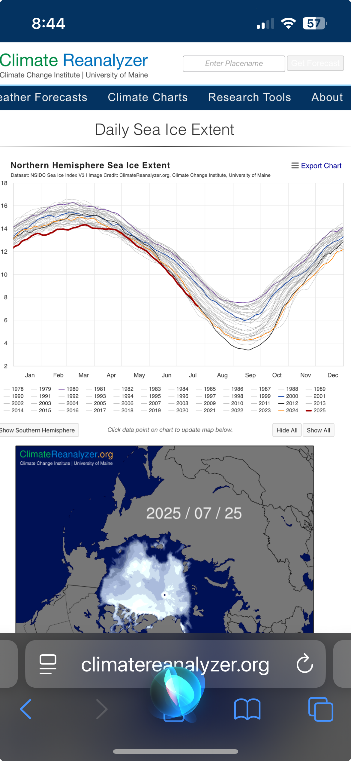
Is this right from the university of Maine? looks like we’re presently a tick below 2012

-
2025-2026 ENSO
Stormchaserchuck1 replied to 40/70 Benchmark's topic in Weather Forecasting and Discussion
Look at how much this cold pool is blowing up on TAO/Triton CPC usually lags a few days to weeks. -
Emptied the bowl but play continues. What a joke.
-

2025-2026 ENSO
donsutherland1 replied to 40/70 Benchmark's topic in Weather Forecasting and Discussion
I don’t believe he is aware of the origins and flaws of the chart. Moreover, he isn’t a troll. In the meantime, a photo from Stonington, ME where it got to 84. Portland hit a record-tying 91, but the heat was tempered here thanks to some showers and considerable cloud cover. The clouds broke during the late afternoon.
-
July 2025 Obs/Disco ... possible historic month for heat
Torch Tiger replied to Typhoon Tip's topic in New England
if you saw a strong storm, it was a top 5'er all day -
18z GEFS actually really gets us cool Aug 1-7. Could open the month with a -3 to -4 first week, per the ensemble mean.
-
 Am fairly satisfied with D1... plenty of svr and narrow streaks of 1-1.5". Even 100 at KEWR and daily RER's here and there. Letting late Sat-Sunday play out. Am confident pockets of FF-SVR, ,mainly NJ-LI... Buoyancy will pretty good, better Bulk Shear and larger PW near 2.4". Let's see what happens.


.png.c81496e39df05bace1d92a827ad9c47f.png)