All Activity
- Past hour
-

2025-2026 ENSO
40/70 Benchmark replied to 40/70 Benchmark's topic in Weather Forecasting and Discussion
Should be great....we are just finishing up an 8 unit housing complex to fuction as an Air b & b. -
 the BDR reading is taken at the airport which sits on a penisula out into the sound-sound water temps are at least mid 70's so can see how they stay elevated this time of year at nighttime
 -

2025-2026 ENSO
Stormchaserchuck1 replied to 40/70 Benchmark's topic in Weather Forecasting and Discussion
Have fun in Africa! -
Hate to do it but that's what they're there for right?
.jpg.eedaa845185c7a488002bf2b6a5fc435.jpg)
.jpg.7b66d6fd090408f21290a4988486b07a.jpg)
-
Just think...one of these years we're going to get a super strong EL Nino where we are ripping 70's in DJF...for multiple days. EWR probably hitting a 90 too.
-
Dews and heat here soon enough. Big big summer stretch coming. Poor Moregarbage.
-
We are working to eliminate those too.
-

SE Area of Interest--10% two day, 30% five day odds
BarryStantonGBP replied to WxWatcher007's topic in Tropical Headquarters
NHS think this not too surprised -
extratropical storm dexter
BarryStantonGBP replied to BarryStantonGBP's topic in Tropical Headquarters
L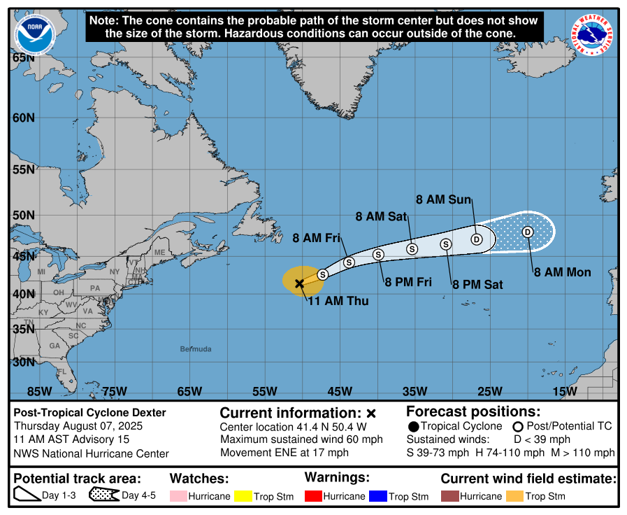
-
 I've been talking about shipping regulations boosting temps for a couple years. The general cleanup of air since the 1990s also contributed big time. And then we also have Hunga Tonga which of course just had to be a massive water vapor booster into the stratosphere instead of an aerosol release.
 -
see what happens when dews are low?
-
Yeah I can see those. Thanks!
-

2025 Atlantic Hurricane Season
WxWatcher007 replied to BarryStantonGBP's topic in Tropical Headquarters
Not to get on a gatekeeper high horse lol but you can definitely justify a thread and analyze as an experienced poster here. Barry (god love ‘em) starting a thread on anything that swirls with an op that is devoid of original information for readers isn’t helpful imo. -
This makes me long for the days of dews talk.
-
2025-2026 ENSO
Stormchaserchuck1 replied to 40/70 Benchmark's topic in Weather Forecasting and Discussion
Thanks for telling me, I ran out of attachment space on this board, and have been uploading them through imagebb. Maybe another image upload site will work for you? Tell me if this works. Also a strong Gulf of Alaska High pressure has been there June-July Analogs US Temp pattern of analogs -
“Prediction remains on track for above-normal Atlantic hurricane season” Forecasters from NOAA’s National Weather Service updated the number of expected named storms to 13-18 (with winds of 39 mph or greater), of which 5-9 could become hurricanes (winds of 74 mph or greater), including 2-5 major hurricanes (winds of 111 mph or greater). The adjusted ranges are for the entire season from June 1 though November 30, and are inclusive of the four named tropical storms that have already formed. In the Atlantic basin, a typical hurricane season will yield 14 named storms, of which seven become hurricanes and three become major hurricanes. The likelihood of above-normal activity is 50%, a 35% chance of a near-normal season, and a 15% chance of a below-normal season. This updated prediction is similar to the initial outlook issued in May. https://www.noaa.gov/news-release/prediction-remains-on-track-for-above-normal-atlantic-hurricane-season —————— I’ve never been a fan of these wide ranges, especially 2-5 MH in this case, but otherwise I appreciate the availability of their predictions.
-
Good points.
-
 While I think this is mostly the result of general climate warming, I think the sudden explosion of heat was aided by the significant reduction in sulfur emissions. Similar to some of the discussion surrounding the impact of recent shipping regulations of sulfur emissions, and its role in ocean warming. The funny thing is you ask certain people on here and they would insist the 1980s, 1990s and early 2000s were scorching hot, even though nationally recent summers easily blow them out of the water.
 -
For some reason I can never see your images. It's always just something like "3aa-14.png". Does anybody else have this problem? I don't comment much, but I always appreciate reading all your comments as well as everyone else's.
-
You can really see the impacts of the enhanced sulfur regulations, coupled with continued warming trends. In the last 15 years, 6 years were hotter than any summer in the preceding 25 years. Only one (2014) was cooler than the median summer for that 25-year timeframe. In fact, every year since 2010, except for 2014, was hotter than at least 17 of 25 summers in the 1985-2009 period. 2025 will almost certainly finish hotter than any summer in 1985-2009, so that would be 7 of 16 years where that was the case. 2 other years (2016 & 2018) were hotter than every summer in the 1985-2009 period, except for 2006. CONUS Summer rankings of each year since 2010, versus the 25-year period 1985-2009 2010: 4th hottest of 25 (behind 1988, 2002, and 2006) 2011: Hotter than any summer for 1985-2009 period 2012: Hotter than any summer for 1985-2009 period 2013: 9th hottest of 25 (behind 1988, 2002, 2006, 2007, 2003, 2001, 2005 and 1998) 2014: 8th coldest of 25 (behind 1992, 2004, 1993, 2009, 1985, 1997 and 1989) 2015: 5th hottest of 25 (behind 1988, 2002, 2006 and 2007) 2016: 2nd hottest of 25 (behind 2006) 2017: 6th hottest of 25 (behind 1988, 2002, 2006, 2007, and 2003) 2018: 2nd hottest of 25 (behind 2006) 2019: 9th hottest of 25 (behind 1988, 2002, 2006, 2007, 2003, 2001, 2005 and 1998) 2020: Hotter than any summer for 1985-2009 period 2021: Hotter than any summer for 1985-2009 period 2022: Hotter than any summer for 1985-2009 period 2023: 5th hottest of 25 (behind 1988, 2002, 2006 and 2007) 2024: Hotter than any summer for 1985-2009 period
-
 Tail end of the current smoke bloom moving from East to --> West from ELI on west.
 -
if you think the noaa cuts are about waste and fraud you're a dummy who's easy to lie to
- Today
-
Huh. Actual bright sun blazin away out there
-
I think that’s a good guideline, but I feel there are exceptions. For example, due to good model support (most importantly including ensembles) for a strong western Atlantic hurricane from it, I feel that the thread for the AEW still in W Africa, despite it not yet being an invest and it not even being on the TWO, is already easily warranted. It will almost definitely be made an Invest and will make the TWO soon. I just posted the rather ominous looking 6Z Euro ensemble for it. I see no problem with already having posts about it siphoned off to its own thread so as to allow this main thread to not be as cluttered. Also, should it end up being a storm, we’d then have posts from further back in time all in one thread to look back at to see how it evolved on the models early on.


.jpeg.5707ce3678691ac865ff43e796dad363.jpeg)


