All Activity
- Past hour
-
The thing is the models shows the thing getting ripped apart clearly, the primary HU models as well (HAFS) Why wouldn't you think that w/ the shear increasing to 40 kt and that much dry air present? There have been other cases like Isaias,, but also cases where unexpected rapid weakening occurs as well (Katrina and LIli are prime examples). So you can't fault ppl for driving the point home. We have a strong baroclinic situation here, so one wouldn't just ignore than. I would not say rapid intensification not long before landfall used to be definite rarity. That is recency bias largely. Since 1995, we have been in an active phase of the AMO for favorable Atlantic TC activity. Also, we are much better in determining absolute intensity now, esp. for the stronger HUs now b/c of things like the GPS dropsonde, which did not come into use until 1998, and the SFMR, which did not exist on recons until 2004. This advancement in tech has allowed us to diagnose *much* better extreme winds that we could not directly measure before. Prior, it was largely just FL winds at 700 mb, but that serves only as a proxy and does not work all the time. Sp in recent decades we are seeing things we never could detect before, but were always there. Also, and this is a biggie, through the 1960s, if a hurricane was thought be 100 kt or stronger, many recons wouyld not penetrate the eyewall and get into the eye for direct measurements. They would fly only as close enough to get a solid radar scan of the eye, and then turn away. So many HUs were underestimated by 1 or even 2 categories at times in the first decades of the recon era!
-
Looks like the more consistent and stronger winds will move into the coastal areas between Pensacola and Panama Beach in the next 30-60 minutes.
-

2026-2027 Record-breaking El Nino
MJO812 replied to Stormchaserchuck1's topic in Weather Forecasting and Discussion
Not a bad look -
Looks like the southern part of the storm is being ripped apart somewhat.
-
-

2026-2027 Record-breaking El Nino
40/70 Benchmark replied to Stormchaserchuck1's topic in Weather Forecasting and Discussion
Heh...DT jumping on the "Second half Modoki" train....that is an exaggeration, but as I have ben saying, it will erode from the east, which will allow for more conducive mid seasonal flip. -
Mild weather prevails. Tomorrow through Monday will see the mercury top out generally in the upper 60s and lower 70s across the region. Sunday will be a bit cooler with highs mainly in the middle 60s. The first half of next week will also feature highs in the lower and middle 60s. The weather will be mainly dry. The next chance for precipitation could be Sunday or Monday. The moisture could be enhanced by the remnants of Isaiah. The ENSO Region 1+2 anomaly was +5.3°C and the Region 3.4 anomaly was +3.2°C for the week centered around September 30. For the past six weeks, the ENSO Region 1+2 anomaly has averaged +4.63°C and the ENSO Region 3.4 anomaly has averaged +2.92°C. Both ENSO regions have set new all-time records. The ongoing strong El Niño, will continue to strengthen through the mid-fall. The SOI was -11.22 today. The preliminary Arctic Oscillation (AO) was +0.960 today. Based on sensitivity analysis applied to the latest guidance, there is an implied near 56% probability that New York City will have a warmer than normal October (1991-2020 normal). October will likely finish with a mean temperature near 58.5° (0.6° above normal). Supplemental Information: The projected mean would be 1.6° above the 1981-2010 normal monthly value.
-
-
 fluoxetine without a prescription: neuroreliefdirect - does gabapentin cause pain
 -
Yep, I'm looking out my window at it 1000 miles away.
-
I'm mostly worried about flash flooding not main stem river flooding
-
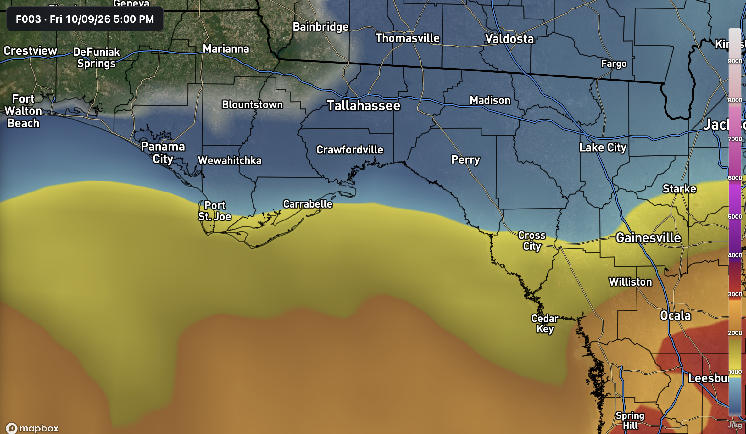
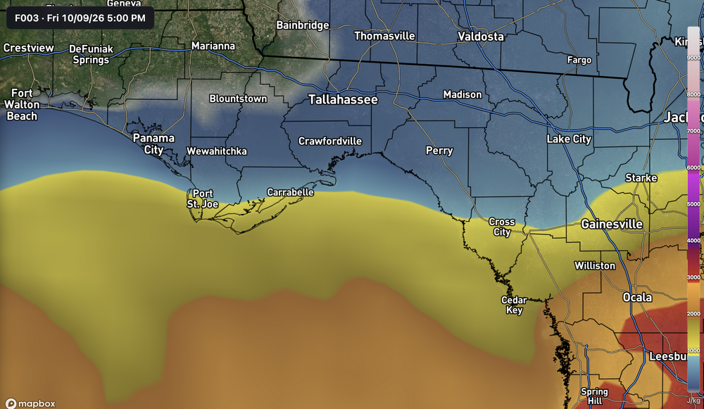
Significant tornado threat looks to be pretty stunted for the next few hours. Nearly zero SBCAPE is making it inland, and storms are getting choked out before they can come ashore. Already happened to a few cells coming up Apalachee Bay.
-
Isaias outflow clouds
-
For a few hours now, the core has been "halved" on radar in terms of an eyewall. I realize there is some attenuation, but if the eyewall ring was complete and intense, we'd easily be seeing a closed ring starting a few hours ago. Ever seem intense TC at extreme range of radars? The eye and a solid eyewall show up very well even 200 nm away! So dry air and shear are have impacted the inner core, however, this has not impacted the central pressure or winds much at all! This shows that the relationship between sig shear and dry air and a HU is complex and it is definitely not one-size-fits-all! As discussed earlier, why did Lili, Opal, and Dennis weaken so much after a solid RI period in and environment not as strongly baroclinic overall than Isaias? Actually, think about Katrina! It went from 150 kt to 110 kt from peak onshore to landfall in ~24 hr with a ton of dry air ingested into the core and quite ragged convective structure compared to Isaias right now. And Katrina was way larger than Isaias, so you would think it could resist dry air intrusions better. Also, Katrina was in Aug. The mean atmosphere as to being conducive for a strong TC that time of year is significantly better than Oct! You don't have troughs of this magnitude cutting across the nrn Gulf in Aug! That being said, the upper level outflow plume for Isaias is outstanding. That unquestionably is a factor here as to keeping it from weakening.
-
.
-
Please no
-
go sox
-
Latest pass 953.7 so looks like it's probably topped out strength-wise, unsurprisingly.
-
toprol xl rxlist [url=http://metocardiorx.com/#]MetoCardio Rx[/url] lopressor generic side effects
-
The satellite imagery in motion sends a message. Isaias is coming our way. Many details remain but the general movement looks good.
-
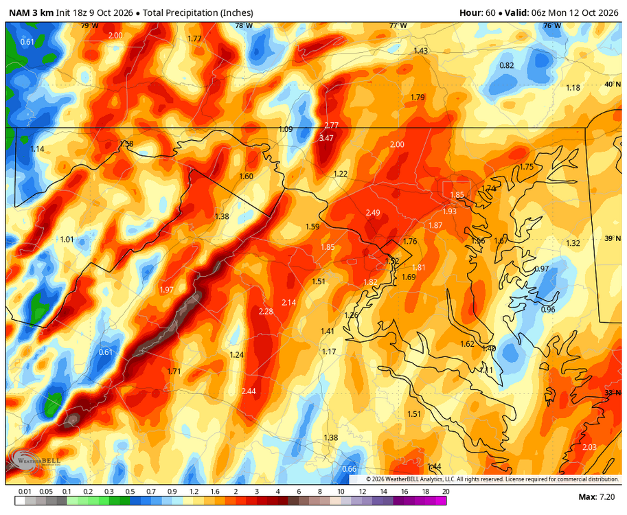
I'm sure everyone will be relieved that the WB 3K NAM is now onboard and not quite done at the end of run.
-
The JMA last had a good Winter forecast in 2013.
-
Hurricane Isaias Discussion Number 13 NWS National Hurricane Center Miami FL AL092026 400 PM CDT Fri Oct 09 2026 Deep-layer shear from the southwest has increased to 30-40 kt, and the hurricane's structure is responding accordingly. WSR-88D radar data shows that the structure is becoming increasingly asymmetric, with very intense convection mainly confined to the northern eyewall. Tail Doppler radar data from the NOAA P-3 has also shown that the circulation is becoming tilted with height. That said, some impressive winds were measured at flight-level--136 kt by the Air Force Reserve at 10,000 feet and 126 kt by NOAA at 8,000 ft. While these winds themselves would normally support a higher intensity, several dropsondes released in the eyewall showed that there is a sharp drop-off of winds at the ocean surface, with layer-averaging suggesting a surface intensity of 90-95 kt. In addition, recent Doppler radar data from Mobile show winds of 100-110 kt at about 10,000 feet in the northern eyewall. Combining all this data together, the maximum surface winds appear to be around 100 kt, although it's very likely that Isaias will be a gustier-than-normal hurricane when it makes landfall. Isaias has turned northward and is accelerating with a current motion of 010/15 kt. The track guidance has honed in on a landfall over the western Florida Panhandle near the Pensacola area sometime this evening. A northward motion is expected to continue through Saturday, bringing Isaias's center through Alabama, followed by a northeastward trajectory across the Tennessee and the central Appalachians on Sunday. The circulation is expected to dissipate by hour 60. The high-resolution hurricane regional models (HAFS-A, HAFS-B, and HWRF), as well as the statistical-dynamical models (SHIPS and LGEM) indicate that Isaias is likely to be at or near major hurricane strength at landfall this evening. After landfall, fast weakening is expected, with some caveats. As mentioned previously, Isaias is likely to be a gusty hurricane, and its fast motion could bring strong hurricane-force gusts well inland. Simulated satellite imagery from global model guidance indicates that Isaias is likely to transition to a post-tropical cyclone over Alabama by Saturday afternoon, although it could still be producing tropical-storm-force gusts, especially in areas of higher terrain. Key Messages: 1. A life-threatening storm surge is expected from the Mouth of the Mississippi River to Suwannee, Florida. Residents under evacuation orders should leave immediately and follow advice from local officials. 2. Extremely dangerous and damaging hurricane force-winds are expected over portions of the Florida Panhandle, southern Alabama, and southern Mississippi where a Hurricane Warning is in effect. Residents in these areas should have a safe room to ride out the storm and prepare for long-duration power outages. 3. Damaging wind gusts are likely over a large portion of the southeastern United States from western and northern Georgia and the southern Appalachians, westward over much of central and northern Alabama, southern middle Tennessee, and Mississippi, especially in areas of higher terrain. Residents should secure loose outdoor items, avoid driving high-profile vehicles, prepare for power outages, and be aware of the potential for falling trees. 4. Isaias will bring areas of heavy rainfall to the central U.S. Gulf coast and much of the Southeast through the weekend. Considerable flash and urban flooding, along with significant river flooding, will be possible. Landslides are also possible across the Southern Appalachians. 5. The tornado potential will continue through tonight. The greatest risk will be east of the center, particularly across the Florida Panhandle into southern Georgia. This risk will continue spreading north-northeast across parts of the Southeast on Saturday. FORECAST POSITIONS AND MAX WINDS INIT 09/2100Z 29.2N 87.0W 100 KT 115 MPH 12H 10/0600Z 31.2N 86.8W 75 KT 85 MPH...INLAND 24H 10/1800Z 33.4N 87.2W 40 KT 45 MPH...POST-TROP/INLAND 36H 11/0600Z 35.6N 86.1W 30 KT 35 MPH...POST-TROP/INLAND 48H 11/1800Z 38.1N 82.5W 25 KT 30 MPH...POST-TROP/INLAND 60H 12/0600Z...DISSIPATED $$ Forecaster Berg
-
Assuming it does not degrade that northern eye wall will mean business when it reaches the coast in the next 2 hours or so. Actual landfall should occur between 10 and 11 pm.
-
BULLETIN Hurricane Isaias Advisory Number 13 NWS National Hurricane Center Miami FL AL092026 400 PM CDT Fri Oct 09 2026 ...CONDITIONS DETERIORATING QUICKLY WITHIN THE STORM SURGE AND HURRICANE WARNING AREAS... ...RESIDENTS SHOULD BE SEEKING SAFE SHELTER... SUMMARY OF 400 PM CDT...2100 UTC...INFORMATION ---------------------------------------------- LOCATION...29.2N 87.0W ABOUT 90 MI...145 KM S OF PENSACOLA FLORIDA ABOUT 125 MI...195 KM SSE OF MOBILE ALABAMA MAXIMUM SUSTAINED WINDS...115 MPH...185 KM/H PRESENT MOVEMENT...N OR 10 DEGREES AT 17 MPH...28 KM/H MINIMUM CENTRAL PRESSURE...959 MB...28.32 INCHES