All Activity
- Past hour
-
Not over IMO.
-
That is bit too early to be impacted by the reversal...lag time is like 15 days at this juncture.
-

E PA/NJ/DE Winter 2025-26 Obs/Discussion
MJO812 replied to LVblizzard's topic in Philadelphia Region
The wave on Sunday ruined this threat. It would have been a nice threat if it stayed in one piece. -
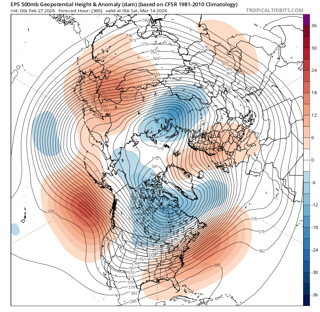
The GEFS takes longer to get to phase 8. Likely around the 20th.
-
Can start to see the phase 8 effects here. Blocking weaker than I expected given the reversal.
-
The GEFS has a very persistent ridge in the East from March 4th to the end of the run. That’s why I’m starting to think after early next week, winter will be over. It was a very good run but I was hoping for a few more weeks.
-
What a difference a week makes. We were tracking at this time non stop last week.
-
Likely will be March 20th through first week of April as the next window.
-
The only thing keeping me from adding a "+" is this last storm was a high-end SECS/low-end MECS imby...coming in around 8-9". But it certainly was an A+ winter for many posters in our forum.
-
good chance given the pattern staying cold over all through early April (Assuming that happens)
-
I just need 3 more. Hopefully we get it .
-
My KU window was off by like 6 days on the blizzard...was March 1-15.
-
This was my best outlook to date in the 11 years I have been doing it, but it wasn't perfect by any stretch. There are avenues for improvement that I will discuss in the post season analysis...most notably, I emphasized the thawing PT regimes too much in the composites, so the temp composites were not cold enough....thought H5 was very good. I pretty much nailed the progression of the strat.
-

E PA/NJ/DE Winter 2025-26 Obs/Discussion
Ralph Wiggum replied to LVblizzard's topic in Philadelphia Region
Which winter month didnt we have snow? Dec 13 storm, Jan 25 storm, Feb 22 storm. You're butthurt because it didnt snow when it was 0 degrees for that 2 week stretch? We had it all this winter my old friend. Minus a significant fzra storm. I give it an A for sure. Im on the fence adding the + We dont get winters like this one very often. This was rather rare territory tbh. Try geritol -
You *DO* need one hard freeze in late March though. Gotta trick all the bugs into coming out and then just when they're ready to become annoying? Kill them all off.
-
It feels like every 3 years or so when the PV breaks down and we get a perfect track cold late April rain storm
-
Yea, -PNA from here on out, as expected....but that was also the case in March 2018, one of my two main strat analogs, along with 2001. It won't be as cold, but not will it be prohibitive to snow.
-
Okay, that is recency bias, but they are prone to getting more vicious blizzard than other other locales when they do get them...that is more what I meant.
-

Winter cancelled/uncancelled banter 25/26
WeatherGeek2025 replied to Rjay's topic in New York City Metro
my question to you guys, how come Central Park temperature is always warmer from the Noaa.gov website compared to the weather.com and iphone app. Currently it's 35 degrees on the noaa.gov while weather app has us at 31 -
19 this am
-
Easter blizzard
-
They can't measure correctly
-
Nams are a nice look for CNE and NNE but work here too.
-
It'd be awesome if you could calculate return rates/quartiles/means with all your interpolations, @The 4 Seasons. Are your products still images, or are they vectorized/rasters? Random, but a colleague sent me an image of your 1888 interpolation yesterday
-

Feb 22nd/23rd "There's no way..." Obs Thread
Hoosweather replied to Maestrobjwa's topic in Mid Atlantic
Hey guys so I’m very late to this as I’ve been awaiting approval of my account but having been at Wintergreen for the storm last Sunday, and having been a long time reader of this board and a poster back in the old days, I just had to get a new account to weigh in. The mountain absolutely received over a foot of snow, and I have no doubt of the 15 inch report. At 7 am we already had 3-4 inches on the ground. It then snowed the next 12 hours straight with snow becoming heavy by noon and from 2-6pm coming down at a rate of 1-2 inches an hour easy. I cleared my car off to try to leave the mountain at 3 and by 3:30 it had another inch on it. It was that kind of snow. We ended up not being able to leave the mountain as at around 3:45 we got stuck on the main road down and they then announced that road, and all roads on the property, were closed. We were able to turn around and get back to our place to spend the night. Everyone at the ski resort itself had to actually stay on the property until roads reopened at 6. I didn’t officially measure during the day- we Skiied all morning and by evening the winds were incredible, but, as noted, at 7am it was already 3-4 inches deep and that was well before the really heavy snow that followed. It’s laughable to say the mountain only got 6-7 inches- there was easily that by midday! Our neighbor did measure in the evening and reported 13 inches. Resort of course said 15 by morning. I’ve been through a lot of big snows. The rate of snow up there from noon to 6 ranks amongst the heaviest I’ve ever seen. It was a remarkable micro-climate moment I’ll never forget! I’ll share some pictures in a bit when I get a little more time.