All Activity
- Past hour
-
 Ahh, the warm front! Your lawn will thank you! LOL.
 -
That a good point. Actually I just looked, and ydy MLS avg high is 91. 102 is wicked hot for us in New England, but when the avg high temp in July is 6-9 F cooler 91 that in places like BOS/PVD/BDL, it is not so hot to residents in Miles City. The notion that 90 is some kind of benchmark for hot wx is misguided, but try telling that to the MSM. Once again, the E Coast bias, more specifically DCA-BOS, applies here, as if that is typical climate! You often hear X percentage of the CONUS or states AOA 90 on any summer day, acting likethat is universally unusual. No it isn't when about 40% of the country has an avg high 90 or higher! Geez, 90 in PHX or LAS in the summer is a *cool* day for them! I was told one time the way to calculate hot, or usually warm, is take the avg high for the location for a given day, and go 2 standard deviations above that. But I am not sure if you can apply that in all seasons, since big temp swings and deviations are much more common in the winter than summer and the closer to the polar regions you get, the bigger the swings overall.
-
CoastalWx gonna pull out his warm front QPF fcst rule of thumb?
-
Pfftt! "Not unlike the blizzard in Feb" as if you can synoptically compare the two? What a bunch of crap! "Ooo, the track is similar!" -- so? That is meaningless by itself. It reminds me of the "Sandy obsession" that occurred for a few years after Sandy occurred. Some national media would put up every hurricane threatening the E Coast "track similar to Sandy." Stupid,. Using a recent high-end event for more hype. Think about so many in NYC and NJ after Sandy and the trauma that occurred from the record storm surge. That's non-trivial stress brought up from ppl just hearing that passively!
-
At some point overnight we picked up 0.48” which brings my MTD to 13.47”. RDU picked up over 1”
-
Some locations in SE MA/RI/CT are going to ended up w. their wettest July on record. And NNE finally gets some as well!
- Today
-
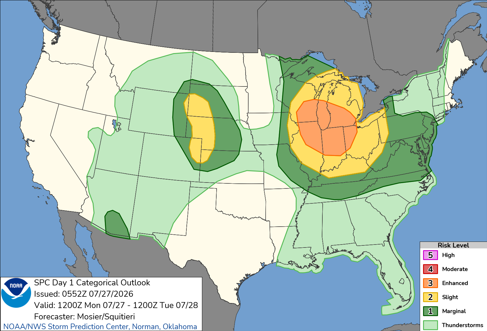
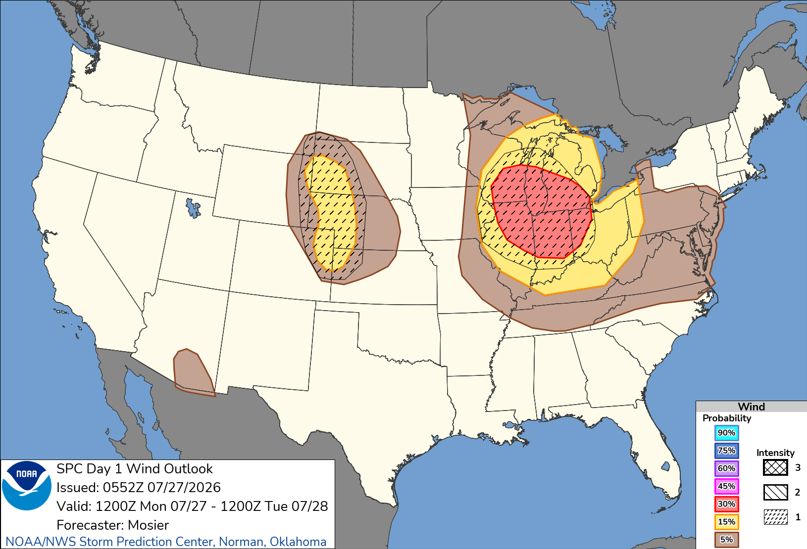
Marginal risk issued here with enh and slgt up north 2% tornado in north area 30-15-5% damaging wind with cig1 hatching also 15-5% hail risk also could have possible upgrades .
-
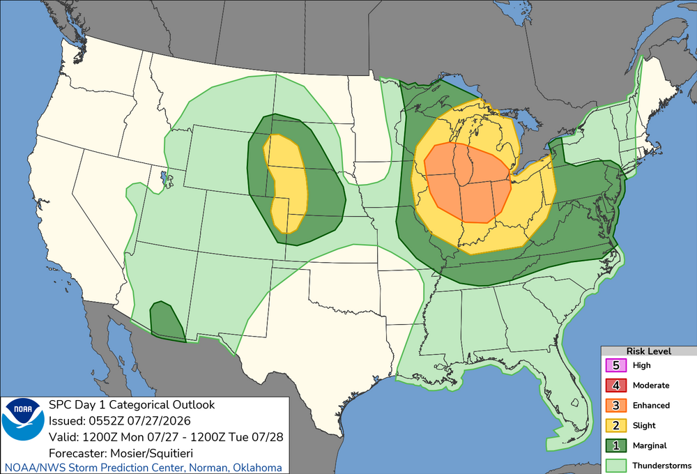
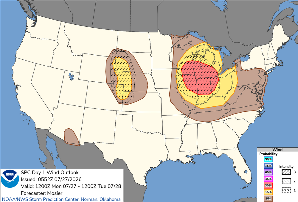
Going all in. If it happens I’ll start the first winter storm thread of the season. Potential for a destructive windbag/derecho Monday. SPC outlining a large Enhanced Risk area with SIG1 hatching. Potential upgrade to CIG2. Day 1 Convective Outlook NWS Storm Prediction Center Norman OK 1252 AM CDT Mon Jul 27 2026 Valid 271200Z - 281200Z ...THERE IS AN ENHANCED RISK OF SEVERE THUNDERSTORMS FROM PORTIONS OF THE UPPER MIDWEST/UPPER GREAT LAKES INTO THE OHIO VALLEY... ...THERE IS A SLIGHT RISK OF SEVERE THUNDERSTORMS ACROSS PORTIONS OF SOUTHWEST SOUTH DAKOTA...WESTERN NEBRASKA...NORTHEAST COLORADO...AND FAR NORTHWEST KANSAS... ...SUMMARY... Severe storms capable of strong to severe wind gusts and large hail are possible across the Great Lakes into the Ohio Valley Monday into Monday night. More sporadic occurrences of damaging wind appear possible in the Mid-Atlantic, Tennessee Valley, central High Plains, and southeast Arizona. ...Upper Midwest/Great Lakes into the OH/TN Valleys... A very moist airmass is in place from the Upper Midwest into the OH and TN Valley. This airmass is exists south of a diffuse cold front that extends from a surface low over far southeast Manitoba southeastward to far eastern Upper MI. One thunderstorm is currently ongoing near this boundary over eastern Upper MI. Most of the thunderstorms are ongoing just northeast another surface boundary demarcating the very moist (i.e. 70+ dewpoints) to it southwest. How this warm-air advection activity evolves early this morning will have a large impact on the severe potential farther downstream from the Mid MS Valley into the OH and TN Valleys through the late morning into the afternoon and evening. Much of the guidance is beginning to suggest the warm-air advection activity clusters early this morning over the MN Arrowhead vicinity before then tracking southeastward within the moisture/buoyancy gradient and organizing/intensifying significantly. Synoptically, the overall setup matches many characteristics of scenarios with strong, forward-propagating MCSs, including a surface boundary parallel to the deep-layer shear, at least modest mid-level warm advection, and very strong to extreme buoyancy. Given the trend within the guidance and favorable synoptics, confidence in the development of a strong forward-propagating MCS is high enough to adjust the 30% wind probabilities westward while also introducing a CIG1 area. There is a chance that both higher wind probabilities and a CIG2 may be needed, but predictability regarding convective evolution is too low at this time.
-
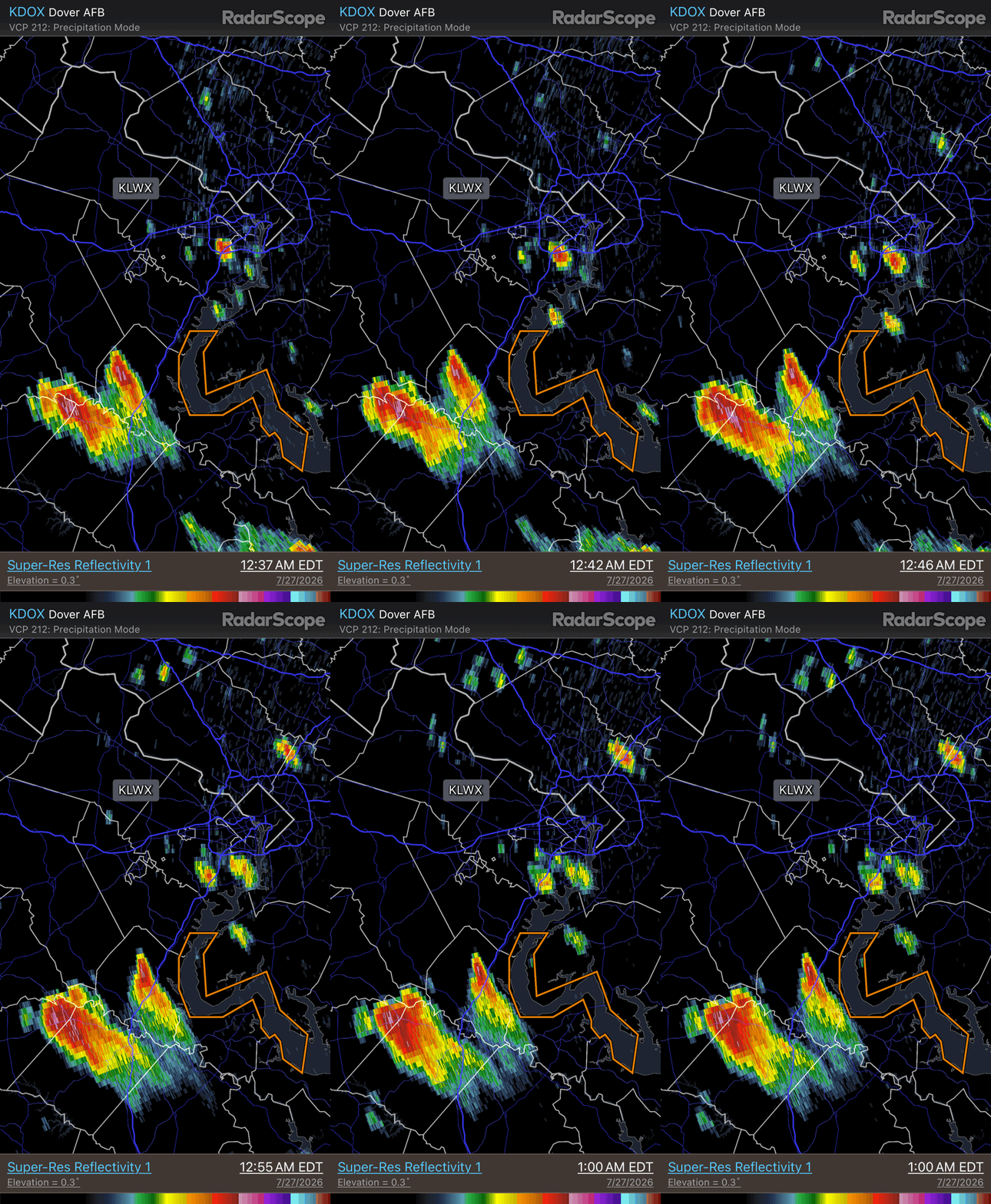
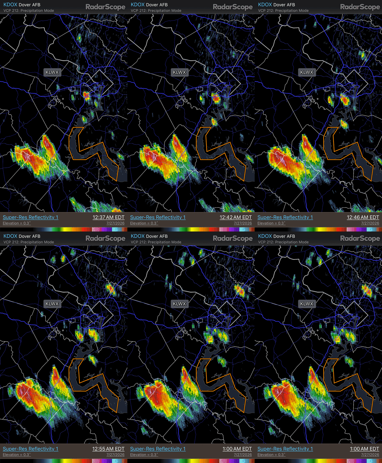
Some overnight action in NW flow. Supercell split here w/ the right most one an anticyclonic supercell (nice, flared, and sheared appearance) A left split, even though it does not look like that for movement, but you have to remember the frame of reference. In NW flow you have to rotate your frame reference 90 deg from typical SW flow. As is typical, the anticyclonic storm moves faster than its cyclonic counterpart. Hail cores aloft (loop is from DOX).
- 1,481 replies
-
- 1
-

-
- severe
- thunderstorms
- (and 7 more)
-
Also, a fairly new type of CAPE, ECAPE! It accounts for dry air entraiment. "Substantial mixing occurs between the upward-moving air currents in thunderstorms (updrafts) and the surrounding comparatively dry environmental air, through a process called entrainment. Entrainment controls thunderstorm intensity via its diluting effect on the buoyancy of air within updrafts." CAPE values we see plotted are almost never full realized due to dry air entrainment. How much entrainment occurs varies greatly. https://journals.ametsoc.org/view/journals/mwre/147/3/mwr-d-18-0137.1.xml AMS24poster.pdf
-
Powerful cell heading SE towards Oshkosh WI, the start of something potentially big.
-
Absolutely drenching rain and thunder but after the first burst the wind isn't as bad.
-
Oh wow hope you and your dog stay safe also stays calm too .
-
The thunder is almost continuous to my north right now. I've got one dog who hates storms and she's just beside herself.
-
Had some thunder earlier east of 65 was quite noisy but pleasant I’ll take another round of rain and thunder peaceful yep ikr was quite hot and steamy out today also looking on satellite looks like there’s a complex diving down from east ky .
-
Maybe you can get some better convevtion if you havent beem touched,dunno https://www.star.nesdis.noaa.gov/GOES/sector_band.php?sat=G19§or=smv&band=EXTENT3&length=24&dim=1&refresh=true
-
I always worry about really strong winds with these, especially when it's really warm ahead of them. Always feels like there's that downburst potential. Hopefully it's just a hard rainer like you said.
-
See what happens,there is a statinonary boundary into Southern KY,with A MCS diving down,shouldnt be severe now,just a drought buster
-
The storm is probably 35 miles north of me but the thunder is already pretty loud and frequent.
-
Peaked 85/76/95 here in town today. Muggy! Cloudy most of the day, but when the sun did peak out temp jumped. Midday, then again during the evening. Some shwrs/stms passed thru, but not much fell.
-
 pharmacies in mexico: MedSelect Mexico - best rx pharmacy online
 -
From an Evansville, IN, pro-met These were the observations at Evansville, IN for 4-5-6pm on July 26, 2026. The dew point readings were 80-80 and 81. The 81 deg. F dewpoint tied the record for highest dew point in history at this location. It happened on 4 previous occasions.
-
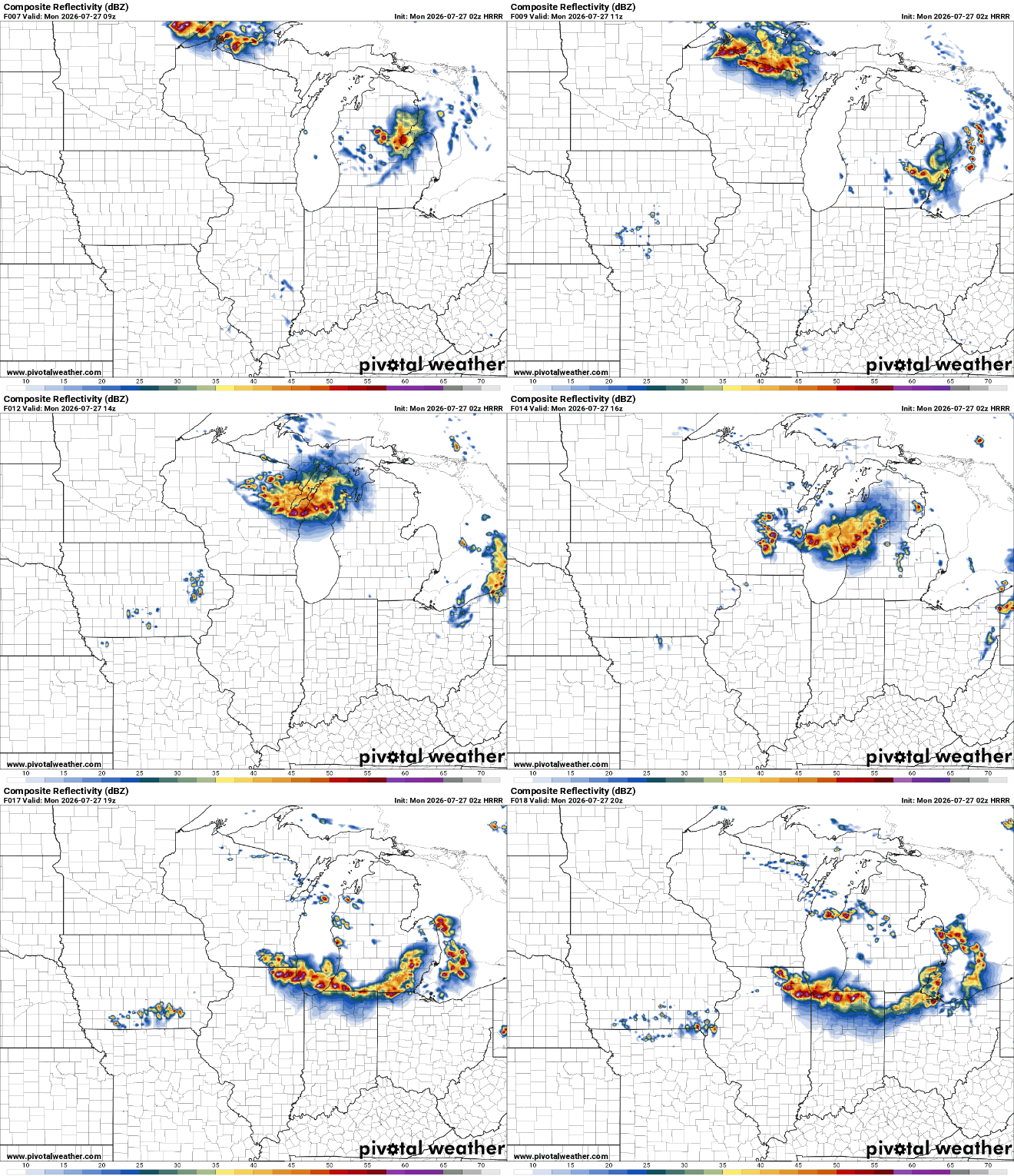
HRRR selling a derecho late morning to early afternoon tomorrow
-
I picked a bad day for baling hay. I think I lost 10lbs water weight. Sent from my SM-G991U using Tapatalk
-
 Bet on the wetter look…it’s been this for the last 3 months. Every frieken week we kill it. Let’s do it again Tuesday plus. It wants to rain mid week..every week. Here we go. Lawns green as can be here…looks like we keep it going!