All Activity
- Past hour
-

26th-27th event, coming at us like a wounded duck.
Go Kart Mozart replied to Go Kart Mozart's topic in New England
Wiz, I gather that the "crosshair" indicates rapid lift through the DGZ. What am I looking for on a skew-T to see that? -

Central PA Winter 25/26 Discussion and Obs
Blizzard of 93 replied to MAG5035's topic in Upstate New York/Pennsylvania
Additionally, most of us are slightly above normal snow for the season to date as well. -
You know its not good when we are relying on the JMA seasonal.. Now that Christmas is over, lets get real about the pattern. It's pretty obvious we are punting until at least January 10. Its not a torch but more of a wash rinse repeat of cutter, brief cool down, warm up, rain. Most seasoned mets and long range forecasts are pointing to the period of January 12-20 for our next real shot of snow. Will that materialize? Who knows but we are about to start wasting prime climo. I don't see a January 2022 repeat next month. Maybe we get a week or 2 period but 2022 was cold for most of the month with multiple snows in different parts of the state.
-

26th-27th event, coming at us like a wounded duck.
bristolri_wx replied to Go Kart Mozart's topic in New England
The NAM has been having trouble with this one. There are always a few storms every season where the NAM is totally out to lunch even when close to the start time. Hard to discount the GFS+Euro+HRRR all looking very similar overall... -
EPS says bye bye Aleutian Ridge
-
Good trends this morning for those of us in Central NJ. No matter how long I'm at this, I STILL underestimate how much things can change at the (relatively) last minute...I was feeling pretty discouraged last night (I'm in southern Middlesex, near the Monmouth border). At this point, I wouldn't be surprised if I get an inch of sleety slop and also wouldn't be surprised if I get six inches of snow.
-

26th-27th event, coming at us like a wounded duck.
Baroclinic Zone replied to Go Kart Mozart's topic in New England
There is a clear difference in being interested in its output and taking them seriously. It has its usefulness in some aspects of storms but overall it’s a garbage model when it comes to winter storms. -
Hrrr flips us to sleet by 8pm then it pushes the sleet line back south
-
@John1122, Mammoth is getting absolutely hammered right about now. Those cam stills are impressive.
-
Fv3
.thumb.png.3d9729d63929e126f03df17abd15ddcf.png)
-

Central PA Winter 25/26 Discussion and Obs
WmsptWx replied to MAG5035's topic in Upstate New York/Pennsylvania
Also, I kinda think we get it. The dude who runs MU's Twitter has a heat bias and is kind of unprofessional about it. That horse has been bludgeoned enough. Just ignore it lol. -
This is going to be a brutal borderline to ride. I wouldn’t be surprised with 2 or 6” and were less than twelve hours out.
-
Central PA Winter 25/26 Discussion and Obs
WmsptWx replied to MAG5035's topic in Upstate New York/Pennsylvania
Yeah I'm really thinking for those SE of like Selinsgrove this may be a non-event. -

26th-27th event, coming at us like a wounded duck.
WxWatcher007 replied to Go Kart Mozart's topic in New England
Still like our map from yesterday. Glad I put in a high ceiling. I could see you with 6-8 easily while lower elevations like East Hartford is at 5-6". Steve is in the 2-5 zone but he probably does pretty well out there too. This should be a good one for CT. -

26th-27th event, coming at us like a wounded duck.
Fozz replied to Go Kart Mozart's topic in New England
The NAM is just a return to reality. Nobody actually believed the 6z QPF when it was completely alone, right? Especially knowing its biases to overamp these systems. -

26th-27th event, coming at us like a wounded duck.
weatherwiz replied to Go Kart Mozart's topic in New England
ehhh some people put faith in the Cowboys every year -

26th-27th event, coming at us like a wounded duck.
dendrite replied to Go Kart Mozart's topic in New England
lol at putting your faith in the 12k nam when it’s well north of consensus. -
Gfs has been pretty consistent to though
-

26th-27th event, coming at us like a wounded duck.
Damage In Tolland replied to Go Kart Mozart's topic in New England
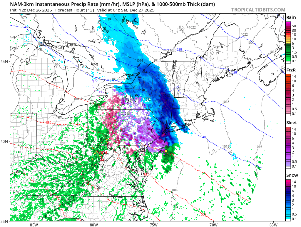
3k is different than 12 -
3k Nam came south with the heavy banding .

-

26th-27th event, coming at us like a wounded duck.
CoastalWx replied to Go Kart Mozart's topic in New England
Think we get a few here which is cool with me. -
26th-27th event, coming at us like a wounded duck.
CoastalWx replied to Go Kart Mozart's topic in New England
Hey Brett, it’s gone in two days anyways. -
Last post for a bit...any time we start seeing big highs in Canada on modeling, that has been a good signal for winter weather in our area. 17-18 would be the exception.
-
26th-27th event, coming at us like a wounded duck.
weatherwiz replied to Go Kart Mozart's topic in New England
You would get into the heavy stuff too on the 3km. The 3km definitely isn't bad looking. Its a wall of snow coming in but it quickly starts to lose its oomph as it moves east. -
Always possible. Every model shows 0.4 to 0.9 of QPF. Time to get the snowblowers ready and enjoy.


.png.7c0a02056464a1f9949e34426e012349.png)