All Activity
- Past hour
-

Feb 22nd/23rd "There's no way..." Storm Thread
Weather Will replied to Maestrobjwa's topic in Mid Atlantic
We wait for Dr. No:
-

“Cory’s in NYC! Let’s HECS!” Feb. 22-24 Disco
Great Snow 1717 replied to TheSnowman's topic in New England
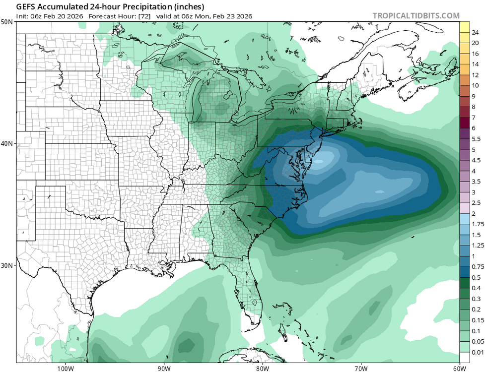
At this point BOX seems to be completely ignoring the GFS ... -

Feb 22nd/23rd "There's no way..." Storm Thread
AmericanWxFreak replied to Maestrobjwa's topic in Mid Atlantic
P7 and P26 on the rocks please . -

“Cory’s in NYC! Let’s HECS!” Feb. 22-24 Disco
CoastalWx replied to TheSnowman's topic in New England
This winter has been exhausting lol. Between hoping for things to work out because the last several have sucked, to the big one actually working out in late January, to the ones that did not work out, and now this lol. Woof. -
Seeing the icon/nam/rgem have a cleaner phase at 6z is extremely encouraging for sure
-
I mean I’m just floored that it’s like 5 or 6 runs in a row that the GFS is straight up locked in. Again I haven’t seen a model do that as an outlier since the NAM with Jonas in Jan 2016. GFS will eventually come to its senses and at that point should be taken behind the woodshed, but holy crap is that fun to watch
-
Let's be real, this is only less than a 6 hour timing difference wrt the 2 shortwaves between being a GFS tucked bomb or a NAM March 2001 rug pull. I will forever have ptsd from that storm and I am getting similar vibes. I am strongly urging cautious optimism from everyone because 1) we still dont have unanimous agreement 2) if the euro isnt biting its probably right and 3) always go with the least snowiest model. Not trying to deb, but alot of us, especially me included, can let emotions take hold. GFS doubled down again but could it be completely wrong and the slp escape east? You better believe that scenario is possible. Ive seen the gfs hold until 12 hours prior before....it can be stubborn.
-

Feb 22nd/23rd "There's no way..." Storm Thread
Solution Man replied to Maestrobjwa's topic in Mid Atlantic
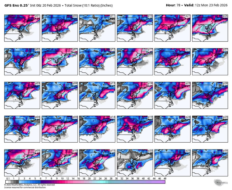
Lots of major hits in there, I choose 26…beat down for all -
.thumb.jpg.6a4895b2a43f87359e4e7d04a6fa0d14.jpg)
Central PA Winter 25/26 Discussion and Obs
Yardstickgozinya replied to MAG5035's topic in Upstate New York/Pennsylvania
This mornings write up from Nws forcast discussion on this weekend’s winter potential. KEY MESSAGE 3: Reminder that it`s still winter with potential for accumulating snow Sunday followed by a brief cold spell with brisk winds Monday and Tuesday. Main chance for snow on Sunday would be more from the inverted trough, still a ways out to pinpoint location and amts of snow with such a feature. Upper level low dynamics might be the key for our area as well. Earlier discussion below. There remains a strong potential for a low pressure system off the Mid-Atlantic coast Sunday intensifying into a nor`easter by Monday. However, the track of the low remains uncertain with plenty of variability in the model guidance. The ECMWF and the UKMET remain farther south and offshore as it exits the coast, whereas the GFS is closest and has the greatest impacts to the Mid-Atlantic region. This is a low confidence forecast at this time with northern and southern stream phasing differences still to be resolved. It seems that even with a more suppressed and eastward track, the associated upper trough and inverted trough axis may be able to provide sufficient forcing/lift to produce a broad area of accumulating snow. Confidence in accumulating snowfall continues to increase, but significant details remain TBD as it relates to the potential for significant snowfall. Confidence is much higher in a reality check back to winter temperatures as a brisk northerly wind behind the departing nor`reaster directs a much colder Canadian airmass back into the region. Max temps on Monday and Tuesday will be 5 to 15 degrees below the historical average. The cold spell won`t last long with a moderating trend commencing through midweek as low level winds turn more southwesterly. Todays full discussion below https://forecast.weather.gov/product.php?site=CTP&issuedby=CTP&product=AFD&format=CI&version=1&glossary=1&highlight=off -
-
Feb 22nd/23rd "There's no way..." Storm Thread
Weather Will replied to Maestrobjwa's topic in Mid Atlantic
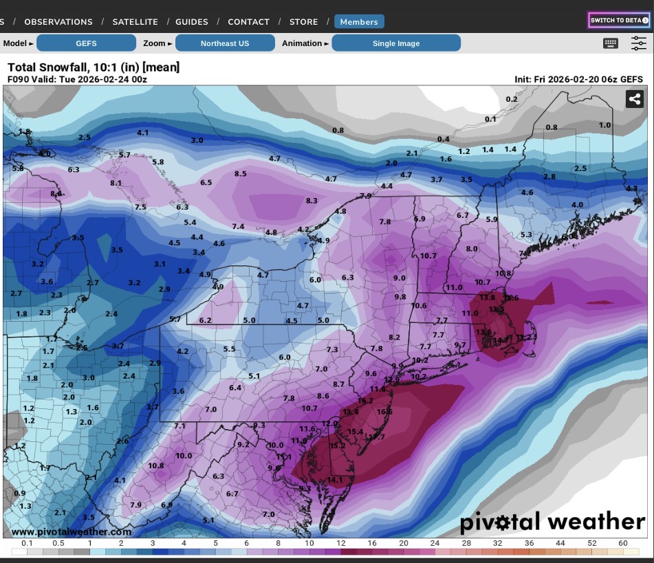
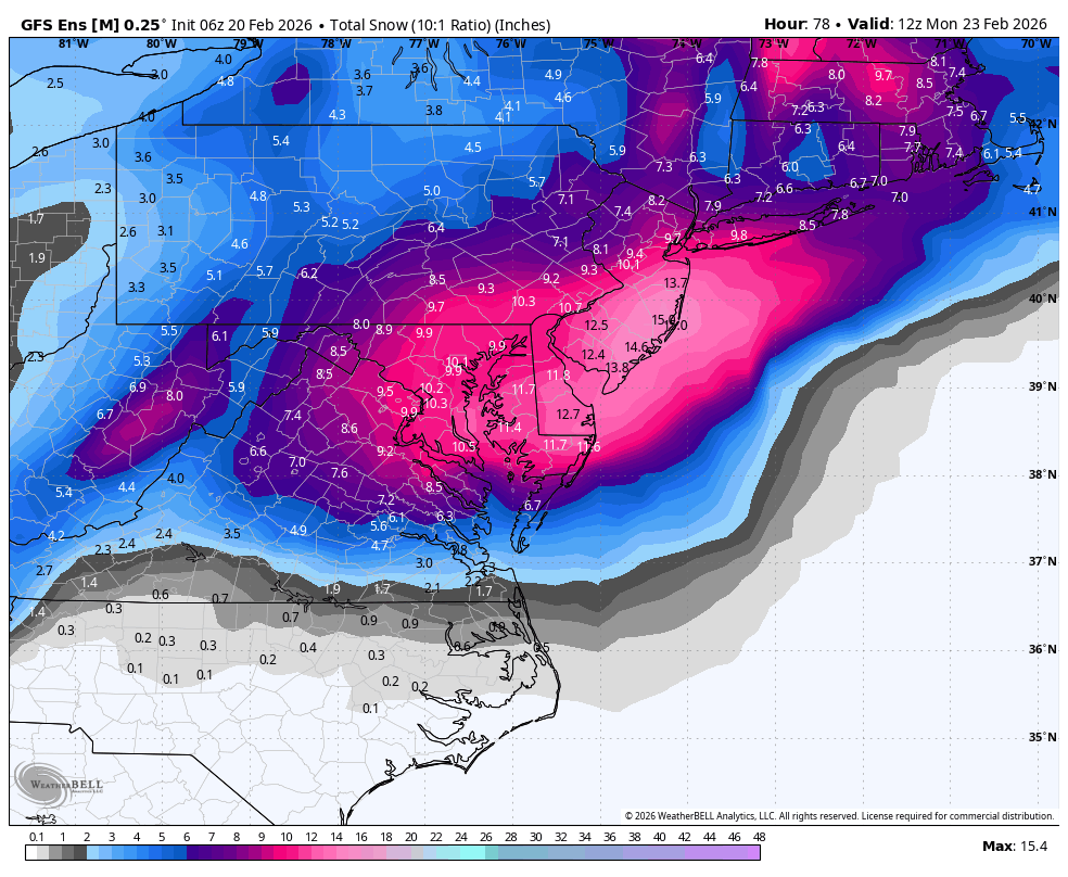
WB 6Z GEFS
-
It's trying It's best to suck our nay sayers in... don't bite yet lol
-
Finally warmed just enough here to clean up the driveway. Had a Kid slam his dodge Dakota into the side of our house early last week at 1:30 a.m...DUI. Launched 25 feet airborne, upside down over the neighbors driveway, slide on the roof through his yard and take out a huge arborviete. The tree flipped his truck back on the wheels and landed against our house in our driveway. The amount of shit from his truck left behind was a mess! Luck the house has little damage except siding
-
-

Feb 22nd/23rd "There's no way..." Storm Thread
Herb@MAWS replied to Maestrobjwa's topic in Mid Atlantic
And it t ain’t over until the fat lady sings. -
I was wondering where tf you got to
-
Precip shield expanded NW interestingly enough. Yes im talking to myself. Dont judge me
-
This is truly unbelievable
-
Looks like dung in a lot of SNE except maybe rt 2 N.
-

Feb 22nd/23rd "There's no way..." Storm Thread
Chris78 replied to Maestrobjwa's topic in Mid Atlantic
Real nice jump NW with the precip shield and heavies
-
“Cory’s in NYC! Let’s HECS!” Feb. 22-24 Disco
CoastalWx replied to TheSnowman's topic in New England
Jesus 6z stuff is like perfect here lol. Yeah curious to see euro guidance later. -
60 hours till go time.
-
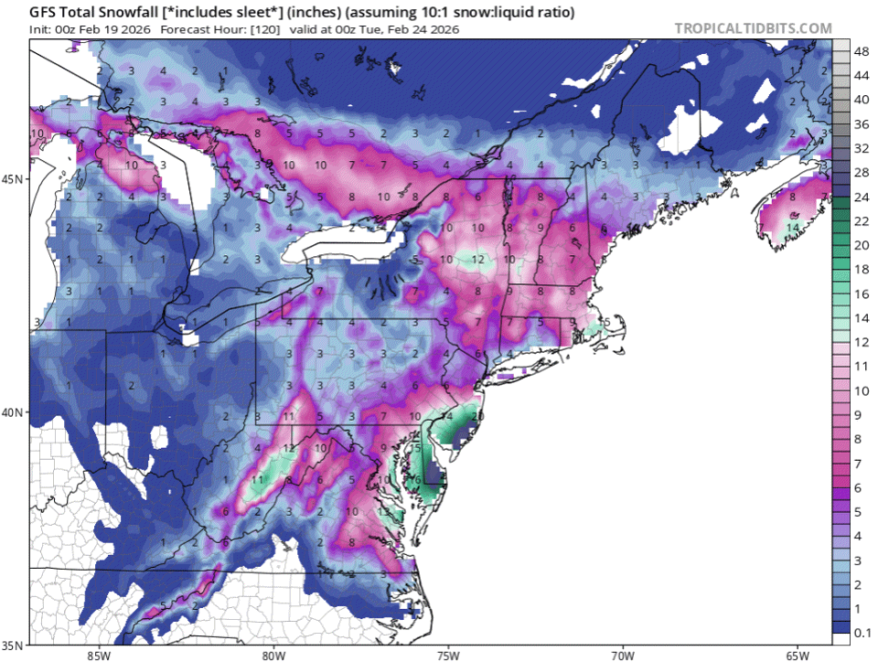
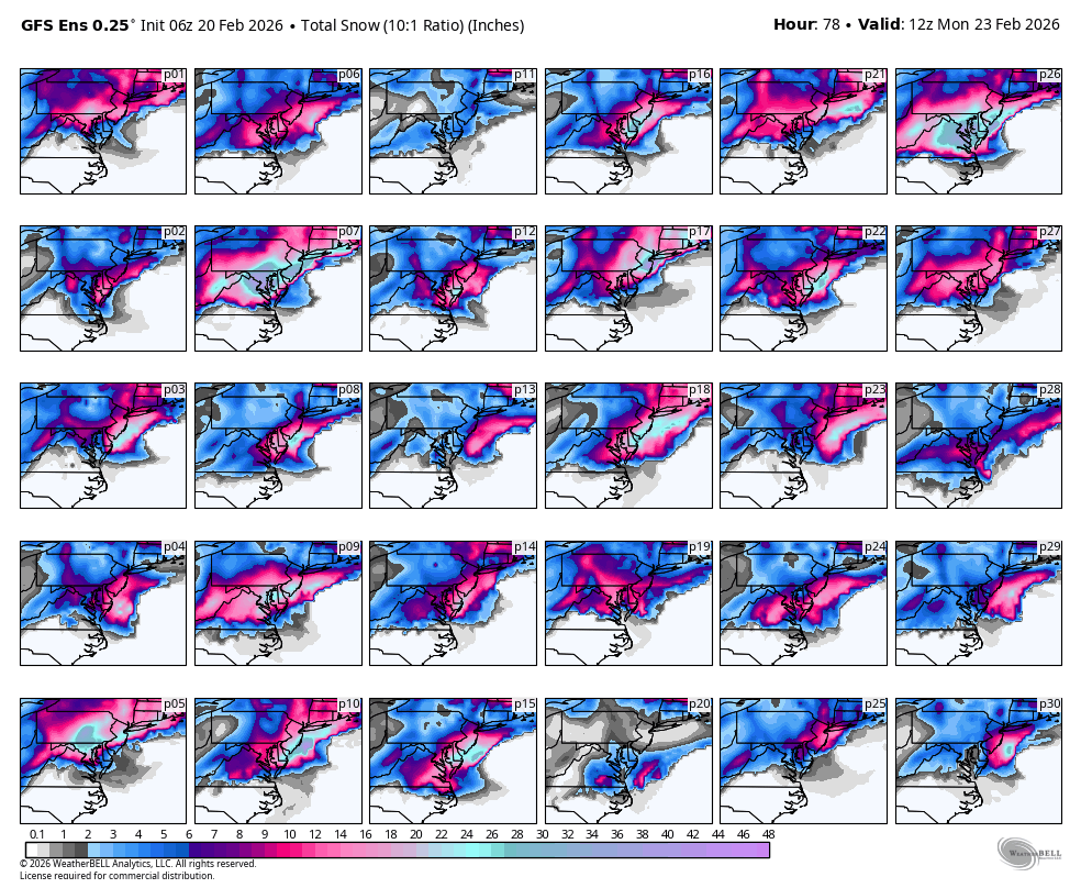
06Z GEFS

-
Looks a tick east aside from 1 or 2 slp centers that held no?
-
Can't wait to see the Euro this morning, will there be any change


.thumb.jpeg.f5c6ba9d911ec96b3b124f8606aee58e.jpeg)