
All Activity
- Past hour
-
anyone got Canaan in WV? Probably upper 20s lol.
-
low of 57 in upper NW, 58 at DCA - first 50s since June I believe.
-
Well, it was discussed in the main ENSO thread that the JMA actually nailed the Aleutian ridge this summer, which is NOT stock El Nino....frankly, neither is the -NAO that is being flagged by all guidance, even the EURO...so they are seeing something beyond ENSO. I think it's valid, albeit overcooked. We aren't getting a DJFM mean -NAO, but it does speak to the volatility of the coming season.
-
You know what's funny... In one of my spring classes we were going over the various models and seasonal models and I remember commenting that the CFS was looking like 1957-1958-ish. I now remember at that time thinking that despite potential for a super strong EL Nino, this winter could surprise and deviate greatly from some of the previous events...maybe I need to get back on that train But I have very little trust in these seasonal models really. I think they are weighted on climatological mean/average, especially when ENSO is a big player. So say if the forecast is for a weak event or a strong event...the output is going to closely resemble that of "averaging" weak or strong events but there is alot of variability between individual events and I am not sure these models are built to "understand" that
-

2026-2027 Record-breaking El Nino
40/70 Benchmark replied to Stormchaserchuck1's topic in Weather Forecasting and Discussion
@GaWxI would say around 120W. -
2026-2027 Record-breaking El Nino
40/70 Benchmark replied to Stormchaserchuck1's topic in Weather Forecasting and Discussion
I usually go with orientation at peak as most representative of the winter season, so December should be pretty representative. I agree, CANSIPS is off. -

Septorcher 2026 Discussion - Endless Summer
TauntonBlizzard2013 replied to Damage In Tolland's topic in New England
42 this morning. Refreshing -
I think we will tap that cold in Siberia for a brief interval or two during the second half.
-

2026-2027 Record-breaking El Nino
GaWx replied to Stormchaserchuck1's topic in Weather Forecasting and Discussion
Compare these to Sep ‘26 warmest JAMSTEC peak period (OND) SSTa longitude of 120-125W, which is between Euro’s 110W and CANSIPS’ 145W. It will be interesting to see which verifies the closest. Do you have a prediction for the warmest longitude at the progged OND peak? Between these 3 model progs, Euro 110W, JAMSTEC 120-125W, and CANSIPS 145W, which do you think will end up the closest?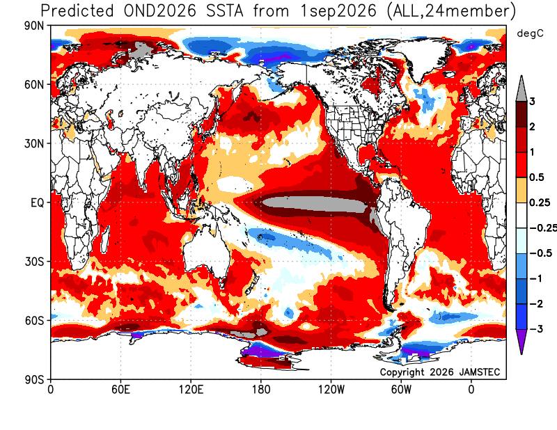
-
Yes....maybe a bit of 1965 and 1986, too....though the latter is a poor extra tropical Pacific match.
-
Yea, I know it will be warm....otherwise I'd be expecting well above average snowfall given the amount of percip. we should see. I think normal snowfall is about our ceiling this year if everything breaks right.
-
We won the toss in 2016 so I'm predicting we lose it this time, lol We only win the super niño toss every other time!
-
Thank you. Well I'll be damned, that probably is some Arctic or Polar air being displaced south into the U.S. Well if that is the case...this could set the stage for a very big winter Actually, going from memory here but this kind of has 1957-1958 vibes?
-

7 More AWOS METAR Sites Now Avaiable
stevejon replied to vortex95's topic in Weather Forecasting and Discussion
The additional AWOS and METAR sites should be useful for improving local observations, especially in areas with limited nearby reporting. The ID change from K2V5 to KRYA is also worth noting for anyone tracking historical data. Having these updates clearly listed makes it easier to keep weather records and forecasts consistent. -

Central PA Summer 2026 Discussion/Obs Thread
WmsptWx replied to Voyager's topic in Upstate New York/Pennsylvania
Went to let the dogs out this morning and saw my breath. At 10:54 it is still 55°F currently. That was a fast crash. -
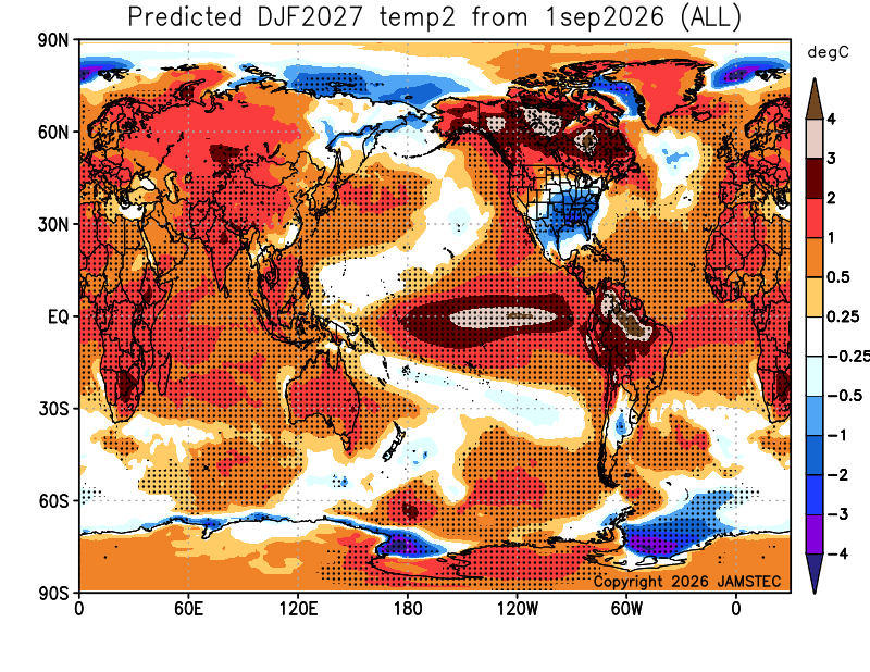
@weatherwiz Believe this is what you wanted to see.
-

2026-2027 Record-breaking El Nino
OSUmetstud replied to Stormchaserchuck1's topic in Weather Forecasting and Discussion
Right. Im not sure what is more relevant. Peak or post-peak during the matching winter months. Cansips is obviously wrong with its anomaly position either way and has been correcting each month for the past 6 or so. -
Beautiful day for a morning walk....
-

Occasional Thoughts on Climate Change
TheClimateChanger replied to donsutherland1's topic in Climate Change
I'm still playing around with my analog pairing idea, where you can see how recent years (2016-2025) compare to prior periods (e.g., 1951-1980 or 1881-1910) and see what locations had the most similar temperature regimes in those earlier years. Maybe with an ability to incorporate modeling to also include future periods like 2041-2070 or 2071-2100. Like for Philadelphia, you could see the ThreadEx stations with the closest winter climate in 1951-1980 are Baltimore (Downtown), MD; Olympia, WA; Caesars Head, SC; Charlottesville, VA; and Oak Ridge, TN. And the closest 1881-1910 winter climates are Knoxville, TN; Nashville, TN; Louisville, KY; Oklahoma City, OK; and Lewiston, ID. The closest 1951-1980 summer climates are Baltimore (Downtown), MD; Kansas City, MO; Norfolk, VA; Elizabeth City, NC; and Myrtle Beach, SC. And for 1881-1910 summers, St. Louis, MO; Norfolk, VA; Wilmington, NC; Raleigh, NC; and Nashville, TN. Or if we only allow locations whose mean temperatures in those periods are at least as high as recent Philadelphia temperatures, then the closest matches are: -
48F. Gorgeous. Can't wait until this low temp is routine and not a just 24-hour aberration between 70F DP lows. I imagine that should occur sometime in January.
-
.thumb.gif.f92b16c631a1d15d405ed77b33f0710d.gif)
Septorcher 2026 Discussion - Endless Summer
Torch Tiger replied to Damage In Tolland's topic in New England
Gfs AI is not far offshore.thumb.png.86c0ccf237d9a021253853c8837a8cb2.png)
-
 canadian pharmacy: online pharmacy canada :: best online canadian pharmacy
 -
Just taking that [temperature] map from face value, I would take that as just a massive flood of PAC air into North America but the structure of those temperature anomalies I think can be the product of two scenarios: 1. A configuration in which Arctic air is displaced well south (akin to a +PNA/-AO combo) 2. Those colder anomalies in the south are the product of extensive clouds and precipitation, so the anomalies are more of a product of diurnal departures versus the result of a pattern favoring colder air displaced south. If that product is showing extreme cold departures on the other side of the hemisphere, then I would absolutely believe scenario 2. Now, obviously, at our latitude even slightly above temperatures can be fine for snow. So I'm not stating we'll be snowless...but it just adds another difficulty we'd have to contend with. But...the structure of the precipitation anomalies, sort of indicates to me increased potential for cyclogenesis off the SE coast...I'd take chances with bringing storms up the coast and just hoping we can get a far enough offshore storm track and pull in some cold. As you know, a "furnace" in southeast Canada does not mean lack of "cold"
-
2026-2027 Record-breaking El Nino
40/70 Benchmark replied to Stormchaserchuck1's topic in Weather Forecasting and Discussion
The December output def. seems further off than the DJF mean, though, Nick.










.png.aedea8dc3a947a213cf748b7a6a5d98f.png)
