All Activity
- Past hour
-

-
End of next week should have a few days 85-90
-
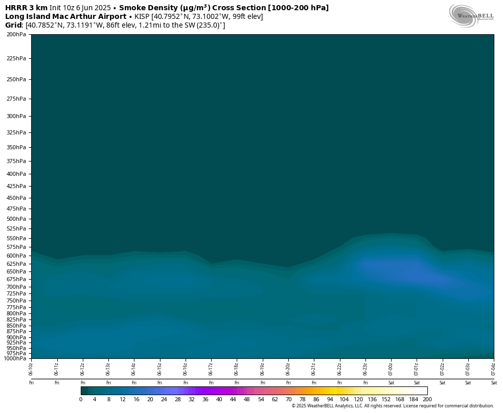
Not as much as the other day thankfully. Some of it is near surface
-
Euro with the fail for Saturday after trying to flood for days. MAGA models got that one.
-
I had assumed that the Canadian Smoke was a major contributor to the Air Quality index.
-

2025-2026 ENSO
40/70 Benchmark replied to 40/70 Benchmark's topic in Weather Forecasting and Discussion
He was definitely wrong about the -WPO (as was I)...that part didn't work out. It was all EPO..I expected the opposite, too, incidentally. -
Is there smoke in the sky? The color of the Sun looks off.
-
Temp 70 and dews dropping. We uninstall.
-
2025-2026 ENSO
40/70 Benchmark replied to 40/70 Benchmark's topic in Weather Forecasting and Discussion
Yea, its not that I didn't believe you...I'm just not sure I buy it as being a huge factor, which isn't to say it has zero creedence...its just that its something I feel is easily overrided by other factors. But again...will I be shocked if this seasn has a glat Aleutian ridge? No, at least not at this early juncture. -
We run the sprinklers. I’ll take the euro rain for Monday. Heat is cancelled anyways for awhile.
-

2025 Spring/Summer Mountain Thread
Met1985 replied to Maggie Valley Steve's topic in Southeastern States
Going to be a booming weekend! -
Unfortunately I can’t find HM’s blog anymore but here is Eric Webb:
-

Central PA Summer 2025
Mount Joy Snowman replied to Voyager's topic in Upstate New York/Pennsylvania
And your wife is still sticking around huh? -
 Bendor802 joined the community
 -
2025-2026 ENSO
40/70 Benchmark replied to 40/70 Benchmark's topic in Weather Forecasting and Discussion
Well, 2011-2012 was a Modoki La Nina and I'm willing to bet that much of the balance of that data set was, as well. I'll sell that...that isn't to say that I am necessarily sold on poleward ridging or a good winter...I just don't buy the QBO connection. I buy the weaker/easterly La Nina poleward ridging data.....2000-2001, 2005-2006 and 2017-2018 are three relatively recent -QBO negative ENSO seasons that featured plenty of poleward Aleutian ridging. -
Could start to see Stein setting back in on modeling earlier this week . Lawns will start torching pike south next week in heat end of week
-
HM, in the extensive blog he wrote up right after the 11-12 winter titled “GLAAMOUROUS”. Also, Eric Webb actually touched on this association a few times last fall and cited a bunch of studies on it
-
Always the bridesmaid. Missed the cores to south and east. At least the pollen got washed away.

-
2025-2026 ENSO
40/70 Benchmark replied to 40/70 Benchmark's topic in Weather Forecasting and Discussion
I don't know where you get this from.... -
Ha
-
If we see a cold-ENSO (cold-neutral/weak La Niña), along with the almost certain -QBO, I’m not so sure we see the strong poleward ridging that we did last winter in the PAC. The +QBO/cold-ENSO we had last winter supported the poleward ridging we saw. -QBO/cold-ENSO favors a flatter, equatorial PAC ridge. As far as the arctic and Atlantic, I would agree with you. The solar/geomag states, QBO evolution and the North Atlantic SSTA profile, at this very early stage obviously, would seemingly not be very supportive of big high latitude blocking in those domains
-
It could very well be a feedback process causing these big ridge expansions further north than we used to get back in the old days. These very strong ridges to the east of New England have been the norm. So the 500 mb ridges warm the waters below and the warmer waters could promote stronger 500mb ridges. Plus there could be remote teleconnections involved from marine heatwaves closer to the equator. Our first 90° Heat of the season is following a familiar theme. The mid 90s major heat missed our area to the north. So the record heat for June 5th was up in Maine and New Hampshire. This was the 2nd year in a row with record early June heat in those areas. Even closer to home, Danbury was 3° warmer than Newark in more over the top to the north fashion. So not sure what caused the comments that the temperature anomaly charts were showing too much red to our north. They turned out to be correct. Augusta Maine had a record high of 92° which was a +20. Newark at 90° was only a +12°. TEMPERATURE (F) YESTERDAY MAXIMUM 92R 2:21 PM 88 2024 72 20 88 TEMPERATURE (F) YESTERDAY MAXIMUM 90 428 PM 95 2021 78 12 81 RECORD EVENT REPORT NATIONAL WEATHER SERVICE GRAY ME 0409 AM EDT FRI JUN 06 2025 ...RECORD HIGH TEMPERATURE SET AT AUGUSTA... A RECORD HIGH TEMPERATURE OF 92 DEGREES WAS SET AT AUGUSTA YESTERDAY, JUNE 5TH. THIS BREAKS THE OLD RECORD OF 88 DEGREES SET IN 2024. Data for June 5, 2025 through June 5, 2025 Click column heading to sort ascending, click again to sort descending. NH ROCHESTER SKYHAVEN AP WBAN 96 ME FRYEBURG EASTERN SLOPES REGL AP WBAN 95 NH MANCHESTER AIRPORT WBAN 94 NH LEBANON MUNICIPAL AIRPORT WBAN 93 ME AUGUSTA STATE AIRPORT WBAN 92 Data for June 5, 2025 through June 5, 2025 Click column heading to sort ascending, click again to sort descending. NJ TETERBORO AIRPORT WBAN 93 CT DANBURY MUNICIPAL AP WBAN 93 NJ CALDWELL ESSEX COUNTY AP WBAN 91 NY PORT JERVIS COOP 90 NJ NEWARK LIBERTY INTL AP WBAN 90 NY MONTGOMERY ORANGE COUNTY AP WBAN 90
-
What a blessing all these widespread soaking rains have been before the heart of the summer. 0.58” yesterday
-
Low of 71 this morning. Boo
-
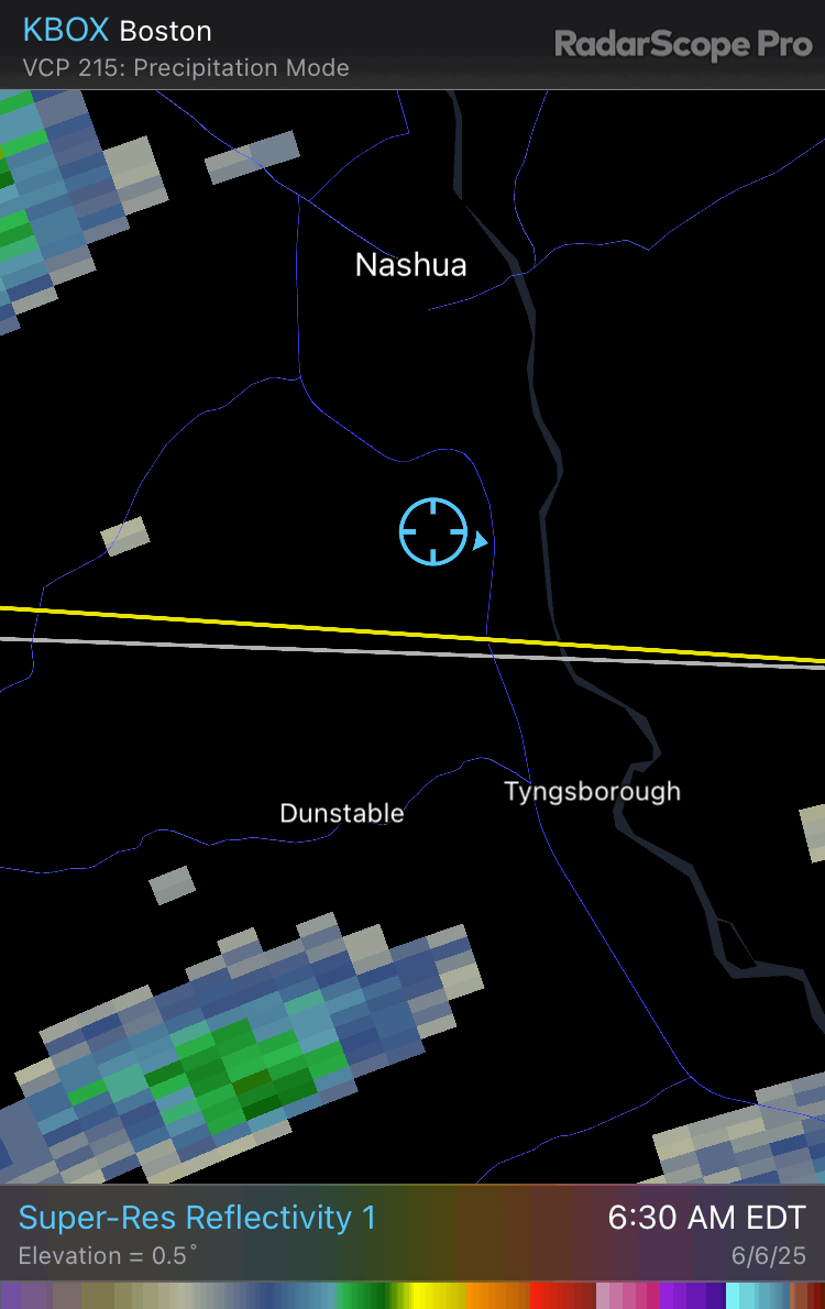
Looks like some decent hail within that storm near Tip
-
50 dBZ over 30,000 ft at 7 am. Not too shabby.