All Activity
- Past hour
-
I've had 2 50" seasons since 2016 (the magic year), 17/18 (53") and 20/21 (51", I'm 37 miles as the crow flies away, so pretty much the same exact climate. Our snow averages are different by 2"). With some very slight adjustments in storm track (probably less than 20 miles) NYC could have had upper 40s to low 50s in those seasons as well (they had 41" in 17/18 and 39" in 20/21). I think that is where "luck" comes into play (being the "winner" vs "loser" in snow cutoffs/being in the best banding) and not CC.
-
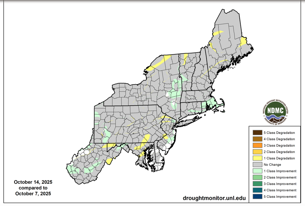
I could benefit from greater u understanding on what went into this lack of reclassifcation downward in NNJ. The yellow stripes e-w across NNJ? Did River flows influence, or local drought reports? Maybe someone can post the radar analysis or whatever went into the evaluation to support the drought monitor. This will help me curb my enthusiasm for expectation. Thank you.

-

Spooky Season (October Disco Thread)
CoastalWx replied to Prismshine Productions's topic in New England
Pretty sure I saw that mentioned somewhere too. Also goes to show you there's a lot we still need to learn. Warmer waters does not equate to more canes. There's a lot that goes into it. -
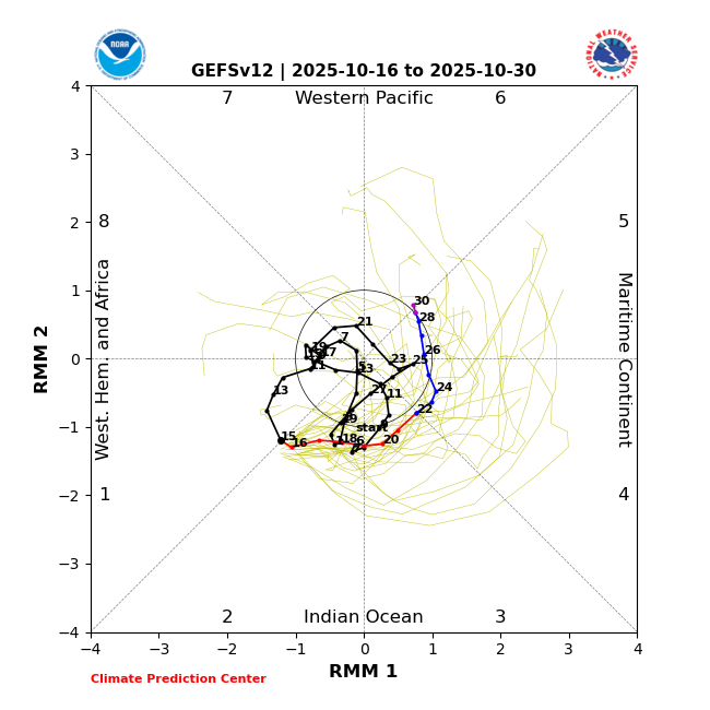
Not sure that the magnitude of this MJO pass is set in stone yet. There are many solutions depicting a stronger MJO pass and the models haven’t been exactly locked in on its strength.
-

Central PA Fall Discussions and Obs
Mount Joy Snowman replied to ChescoWx's topic in Upstate New York/Pennsylvania
Low of 39. Looks like the @Blizzard of 93 540 line makes an appearance over the Commonwealth next week. #WinterIsComing -
Same for me.
-

Spooky Season (October Disco Thread)
Torch Tiger replied to Prismshine Productions's topic in New England
I have that clipped on sound board lol. Won't let me upload here -
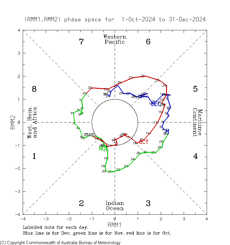
Yeah, weaker amplitude MJO through 4-6 than last year which was what I was expecting. The strong amplitude October MJO 4-6 years like 2024, 2020, and 2017 preceded the stronger +PNAs from December into January. The weaker years like 2022, 2021, and 2016 had a lower PNA. So this fits with my early thinking that this winter will be warmer than last year. But my guess is that there could still be some +PNA intervals but not to the extent of last winter. Snowfall is a bit more of a wild card. Since the snows were so low winter, it wouldn’t take much for an equal or better snowfall outcome. But that won’t be known until I see the December snowfall indicator. I am hoping that we can change up the dominant cutter,hugger,and suppressed Southern Stream storm tracks at least for a few weeks to maybe one month. That will probably be MJO dependent and not known until we get close to the time it starts showing up the medium range models.

-
Judoo?
-
BTW, this concept isn't, or shouldn't be unique to the SAI, either....it's pretty universally folly to base a seasonal outlook on any one factor...the more eclectic, exhaustive and multiperspective, the better-
-
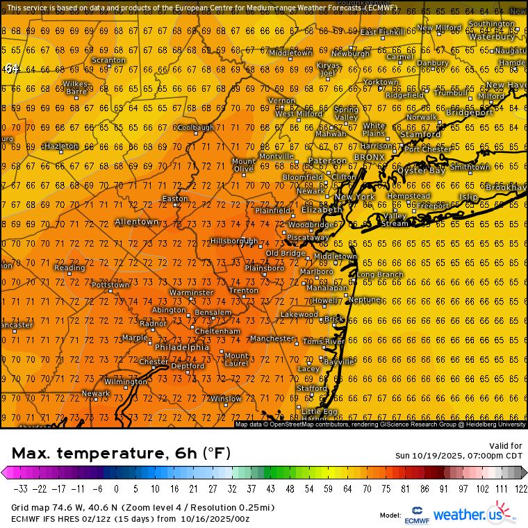
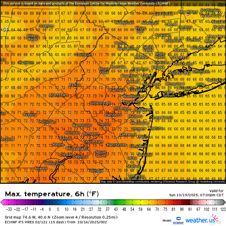
Yeah, JFK and several spots in NJ and Eastern PA made it to 70° on the offshore flow. Looks like areas in NJ will be favored for more 70s this weekend. But probably too much onshore flow at places like JFK. Data for October 15, 2025 through October 15, 2025 Click column heading to sort ascending, click again to sort descending. DE WILMINGTON AIRPORT WBAN 73 DE GEORGETOWN-DELAWARE COASTAL AIRPORT WBAN 72 PA PHILADELPHIA INTL AP WBAN 72 NJ ATLANTIC CITY INTL AP WBAN 72 NJ MILLVILLE MUNICIPAL AIRPORT WBAN 71 NJ SOUTH JERSEY REGIONAL AIRPORT WBAN 70 NJ SOMERSET AIRPORT WBAN 70 Data for October 15, 2025 through October 15, 2025 Click column heading to sort ascending, click again to sort descending. NJ NEWARK LIBERTY INTL AP WBAN 72 NJ TETERBORO AIRPORT WBAN 70 NY JFK INTERNATIONAL AIRPORT WBAN 70
-

Spooky Season (October Disco Thread)
40/70 Benchmark replied to Prismshine Productions's topic in New England
We need the "sick brag, bro" clip from WEEI -
45 degrees this morning feels great. Driving my kid to school, 13 years old logic,no hoodie or sweatshirt just t-shirt with 45 degree temps but wears either when it's 80 plus. Smh lol
-
Perfectly stated
-
I think the "fraudulent" claims are too far on the other end...like most elements of research concerning seasonal forecating, it's importance was initially overstated due to a combination of our lust for skill in this arena combined with today's overzealous portrayal on social media. It has it's value if used properly in concert with a multitude of other factors, but said value was undoubtedly intially overstated. I usually give it a shout out near the end of the polar section of my final outlook, but it's more of a confidence bolsterer/voice of dissent. It's not the basis of the forecast, nor should it be for anyone.
-

2025 Lawns & Gardens Thread. Making Lawns Great Again
dendrite replied to Damage In Tolland's topic in New England
My oaks took a major color turn overnight. This wind is ripping most of the leaves off the other trees now. My armstrong red maple is a deep red/burgundy right now. -

Spooky Season (October Disco Thread)
Typhoon Tip replied to Prismshine Productions's topic in New England
Not to toot horns or anything but ... I remember posting back in spring that I thought this season would be challenged. The reasoning cited was because of the - wait for it! - expanded HC phenomenon. Not just endemic to this season ... it's all summers going forward until the phenomenon historically reverses - when humanity goes extinct and is no longer terraforming the world ... but that's another debate altogether. I think we can still get the higher end predictive quotas... but TC life behaviors are that they tend to spin up faster, and can reach big intensity, but also don't last as long because of what's going on in the paragraph below... See ... ( just in case one person is actually interested - ), an expanded HC is not a stronger HC. It is a weaker one. The more it expanse, the less identity it has as an actual circulation. It starts to fracture... More trough meanders and TUTT riddled. This both lowers the probability that an MDR transport makes it that far before encountering either a polarward steering interference, or an enhanced shear. Looking back at this season and well ... it seems pretty clear that both those circumstances were observed as being particularly interfering. Maybe I just got lucky with this overall idea? but I don't think so. -
Spooky Season (October Disco Thread)
dendrite replied to Prismshine Productions's topic in New England
Not sure if it was legit, but FVE briefly reported -SN at the ASOS this morning. -

Spooky Season (October Disco Thread)
Ginx snewx replied to Prismshine Productions's topic in New England
Better chances coming up soon. -
Spooky Season (October Disco Thread)
40/70 Benchmark replied to Prismshine Productions's topic in New England
11 summers I have ben doing this blog and this is the first without so much as a mention of the tropics, which means there were 0.00 viable major US threats. -
The snow cover advance has to be one of the biggest frauds out there.
-
(002).thumb.png.6e3d9d46bca5fe41aab7a74871dd8af8.png)
Central PA Fall Discussions and Obs
ChescoWx replied to ChescoWx's topic in Upstate New York/Pennsylvania
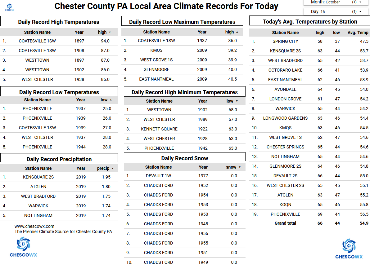
Many of our valley spots across the area saw lows this morning in the 30's with the lowest being our typical coldest spot up in Warwick Township at 33.2 degrees. While some higher spots like West Grove only made it as low as 42.8 degrees. There are a couple of below normal temperature days on the way both today and tomorrow before we moderate to near normal by Saturday and briefly above normal on Sunday before we chill down again to start the new work week. Next rain chances arrive on Sunday night with the next cold front.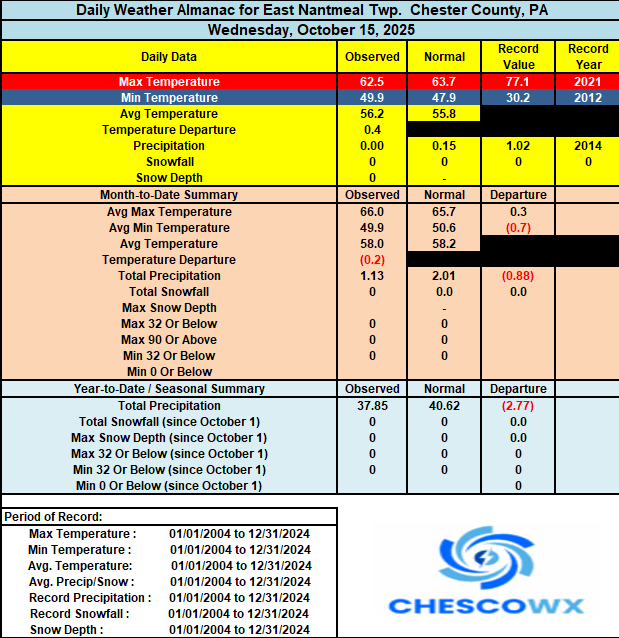
-
E PA/NJ/DE Autumn 2025 Obs/Discussion
ChescoWx replied to PhiEaglesfan712's topic in Philadelphia Region
Many of our valley spots across the area saw lows this morning in the 30's with the lowest being our typical coldest spot up in Warwick Township at 33.2 degrees. While some higher spots like West Grove only made it as low as 42.8 degrees. There are a couple of below normal temperature days on the way both today and tomorrow before we moderate to near normal by Saturday and briefly above normal on Sunday before we chill down again to start the new work week. Next rain chances arrive on Sunday night with the next cold front.
-
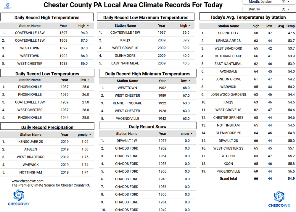
Highs: EWR: 84 (1958) NYC: 87 (1897) LGA: 82 (1958) JFK: 79 (2008) Lows: EWR: 31 (1944) NYC: 34 (1876) LGA: 39 (2009) LGA: 39 (2006) Historical: 1781: A storm of "unknown character" struck Virginia. The Earl of Cornwallis, at Yorktown, was trapped by the French Fleet and the Patriot Army, under the command of George Washington. The Earl decided to flee to the north to Gloucester Point under the cover of darkness. A "furious storm" doomed the plan to failure, as seas ran high and every boat was "swamped". He sent forward his flag of truce and surrendered, thus ending the battle (Chapman). (Ref. Storm of 1781) 1880: Very early blizzard in Dakotas ends and precedes severe winter. Earliest blizzard in Minnesota. Struck western Minnesota and the eastern Dakotas especially hard. Over a foot of snow in western counties. Railroads were blocked. Damage done to Great Lakes shipping. Huge drifts exceeding 20 ft formed in the Canby area lasted until the next spring when flooding occurred across the Minnesota River Valley. (Ref. AccWeather Weather History) 1913 - The temperature in Downtown San Francisco soared to 101 degrees to equal their record for October. (The Weather Channel) 1937 - An unlikely winter-like storm produced as much as ten inches of snow in Minnesota and Iowa. 1944: The 1944 Cuba – Florida hurricane, also known as the Pinar del Rio Hurricane, struck western Cuba on this day as a Category 4. This storm killed an estimated 300 people in Cuba and nine in Florida. This hurricane is currently the 7th costliest U.S. Atlantic hurricane, with an estimated $46.9 billion (2015 USD) in damages. 1962: Severe weather across northwestern Oklahoma resulted in a 5-inch hailstone collected in Woodward County. (Ref. Wilson Weather History) 1987 - Ten cities in the southeastern U.S. reported record low temperatures for the date. The low of 34 degrees at Augusta GA marked their third straight morning of record cold. A cold front brought showers and thunderstorms to parts of the central U.S. Lightning struck a bull and six cows under a tree near Battiest OK. (The National Weather Summary) 1988 - Late afternoon thunderstorms produced severe weather in southwestern Lower Michigan and northern Indiana. One thunderstorm spawned a tornado north of Nappanee IN which caused half a million dollars damage. Six cities in California reported record high temperatures for the date. The afternoon high of 100 degrees at Red Bluff CA was the latest such reading of record for so late in the autumn season. (The National Weather Summary) (Storm Data) 1988: An F2 tornado carved a 6 mile long, east-northeast path through a mostly rural area of north-central Indiana. The extremely slow-moving tornado touched down 1.5 miles north of Nappanee, just 300 yards north of a high school, and shortly after that moved through a subdivision where 11 homes sustained damage. 1989 - Heavy snow blanketed the foothills of Colorado. Up to three inches was reported around Denver. Echo Lake was buried under nineteen inches of snow. Temperatures again warmed into the 80s and lower 90s in the eastern and south central U.S. Thirteen cities reported record high temperatures for the date, including Atlantic City NJ with a reading of 84 degrees. (Storm Data) (The National Weather Summary) 1998: One of the costliest hail storms to ever hit metro Denver caused an estimated $87.8 million dollars in damage to homes, buildings and vehicles. The hailstorm, rare for so late in the season began over portions of Arvada, Wheat Ridge and northeast Denver where mostly pea sized hail accumulated up to a depth of 6 inches near I-70. Snowplows had to be called out to clear several streets and many accidents were reported. The storm intensified as it moved to the east into the Denver and Aurora areas. Hail up to two inches in diameter pelted the Denver metro area and one inch diameter hail in northern Aurora. (Ref. Wilson Weather History) 1990: Temperature reached 90 °F for 136th day in Tampa, FL. (Ref. AccWeather Weather History) 1992: 60+ middle school football players were on the Dueitt Middle School football field (Spring, TX) when lightning hit during a light drizzle. 34 students/coach taken to a hospital for observation/treatment, fortunately; no one was killed. (Ref. Weather Guide Calendar with Phenomenal Weather Events 2011 Accord Pub. 2010, USA) 1999: Hurricane Irene moved across the Florida Keys producing heavy rainfall, strong winds, and high waves. A gust 102 mph was reported in Big Pine Key. 2007: A blinding sandstorm in the high desert north of Los Angeles wreaks havoc with local traffic causing a highway pileup involving dozens of vehicles. Two people die, and 16 are injured as a result of the storm, which reportedly raised dust to 1000 foot high. 2015: A well-defined waterspout was visible from Marquette, Michigan.
- Today
-
Could break the record high Sat around here ahead of the CF,possibly even some severe storms,we could use some rain again here,we've went into a lull lately once again with any liquid