All Activity
- Past hour
-

2025-2026 ENSO
PhiEaglesfan712 replied to 40/70 Benchmark's topic in Weather Forecasting and Discussion
I'm pretty sure this 2-year ACE record is going to stand for a very long time. 6 2004 226.94 1 2005 247.65 Even in this era of more storms, we've only had 2 hyperactive ACE seasons post-2005: 8 2017 224.8775 11 2020 180.3725 -

September 2025 OBS-Discussion centered NYC subforum
SACRUS replied to wdrag's topic in New York City Metro
79 / 57 here -
September 2025 OBS-Discussion centered NYC subforum
SACRUS replied to wdrag's topic in New York City Metro
We had a period of warmer SST vs normal in the late Jun - late July period then Erin caused tremendous upwelling and the recent easterly barrage has created the current cool pool anomaly. -

Invest 92L--50% two day, 90% five day odds
WxWatcher007 replied to WxWatcher007's topic in Tropical Headquarters
Models are quite robust once 92L gets north of the islands. -

September 2025 OBS-Discussion centered NYC subforum
Big Jims Videos replied to wdrag's topic in New York City Metro
What was nice this summer was unlike in 2024, when upwelling kept water temps in the 50s most of the summer, this year it was 70s from June through now yet. -
Saw him post Duck, NC with 51 mph sustained winds with gusts to 59
-

Central PA Summer 2025
Mount Joy Snowman replied to Voyager's topic in Upstate New York/Pennsylvania
We were staying with some friends just outside of Bethany, so went to Bethany Beach one day and the Delaware Seashore State Park beach another day (the area just south of the Indian River Inlet with the Big Chill restaurant and bar area). -

Invest 92L--50% two day, 90% five day odds
GaWx replied to WxWatcher007's topic in Tropical Headquarters
Tropical Weather Outlook NWS National Hurricane Center Miami FL Issued by the NWS Weather Prediction Center College Park MD 200 PM EDT Mon Sep 15 2025 For the North Atlantic...Caribbean Sea and the Gulf of America: Central Tropical Atlantic (AL92): A broad area of low pressure has formed roughly midway between the Windward Islands and the coast of west Africa. This system has become better organized since yesterday and is expected to move through a favorable environment for further development. A tropical depression or tropical storm is likely to form by the middle to latter part of this week as the system moves west-northwestward at 10 to 15 mph over the central tropical Atlantic. * Formation chance through 48 hours...medium...50 percent. * Formation chance through 7 days...high...90 percent. $$ Forecaster Blake/Putnam -
Good. Need this to hold off until about 12:00 pm tomorrow.
-
Traveling thru Turkey for 2-1/2 weeks before heading further south to the Greek island Samos. Talk about dry: 10 days ago in Istanbul it rained some. First rain there since May. Just my luck. Probably no more than 1/4”. 90 or higher every day there but nice cool nights 50s/60s by the time I reached Cappadocia region. Soot in the air, haze, and it just hangs along the mountains. Now am more south toward Greece in Selcuk, again no rain and 95 or better each day. You can almost taste the dust. Worst part is I can’t watch three Ravens games. Even if I could have watched the Bills game (and am glad I missed it) …. it started at 3am Monday here.
-
Invest 92L--50% two day, 90% five day odds
GaWx replied to WxWatcher007's topic in Tropical Headquarters
12Z runs: -GFS/CMC favoring an H but well E of Bermuda -Euro is very close to but just NE of Bermuda with an H -Icon is well to the SW of those other 3 and it’s fate is still unknown at 180 with it a TS S of Bermuda just starting a NW recurve -12Z JMA out to 72 so far: TC moving NW way out there -12Z UKMET like prior run threatens Bermuda with this run aimed only a little E of there: NEW TROPICAL CYCLONE FORECAST TO DEVELOP AFTER 54 HOURS FORECAST POSITION AT T+ 54 : 17.5N 46.9W LEAD CENTRAL MAXIMUM WIND VERIFYING TIME TIME POSITION PRESSURE (MB) SPEED (KNOTS) -------------- ---- -------- ------------- ------------- 0000UTC 18.09.2025 60 18.3N 47.8W 1007 41 1200UTC 18.09.2025 72 20.5N 50.5W 1007 43 0000UTC 19.09.2025 84 21.3N 53.4W 1007 41 1200UTC 19.09.2025 96 22.5N 55.5W 1007 31 0000UTC 20.09.2025 108 23.3N 57.0W 1007 32 1200UTC 20.09.2025 120 25.2N 58.1W 1007 38 0000UTC 21.09.2025 132 26.6N 58.4W 1004 44 1200UTC 21.09.2025 144 27.7N 60.4W 1002 41 0000UTC 22.09.2025 156 29.0N 61.7W 999 49 1200UTC 22.09.2025 168 30.6N 62.4W 995 51 -
I'd be happy with that. Best firewood drying season ever.
-
2025 Atlantic Hurricane Season
WxWatcher007 replied to BarryStantonGBP's topic in Tropical Headquarters
It’s just so devoid of central deep convection though. If the center was tucked under the convection it’d be a different story. Same impacts at the end of the day. -
Seems like some decent southerly shear going on. Naked swirl with bursts of convection off to the north. I don't think TPC is going to do anything with this.
-

September 2025 OBS-Discussion centered NYC subforum
MANDA replied to wdrag's topic in New York City Metro
I think the cool pool has been in place / developing since Spring? Somebody I'm sure can confirm that. -
September 2025 OBS-Discussion centered NYC subforum
MANDA replied to wdrag's topic in New York City Metro
Also have to believe that is keeping the humidity in check when the wind is off the water as opposed to having a warm pool there as we've had over the last several years. Also have to believe that maybe the cool pool is keeping heavy rainfall events in check when conditions favor such events. -
Bastardi is mad that this isn’t being highlighted in the NHC TWOs so far. Remember the recent no name system that hit SE NC with extreme flooding along with TS force sustained winds? JB is still mad about that and I don’t blame him.
-
The thing is that the season started with significantly warmer subtropical than tropical SSTs in the absolute sense, an uncommon setup. That’s evidently added to unusual tropical stability. After that, we added an unusual E US mean upper trough since August, which itself may be a separate factor negative for development. However, neither of those will likely carry over to W Caribbean season as a negative for future development. Plus we have Invest 92L now, which prior to 12Z runs had strong support for TCG.
-

September 2025 OBS-Discussion centered NYC subforum
FPizz replied to wdrag's topic in New York City Metro
12z Ukie pretty wet - Today
-

September 2025 OBS-Discussion centered NYC subforum
Brian5671 replied to wdrag's topic in New York City Metro
some of the 12z runs have a bit of an inverted trough feature over the region... -

September 2025 OBS-Discussion centered NYC subforum
Sundog replied to wdrag's topic in New York City Metro
This is the wettest Euro run yet for the coastal low. This is 6z: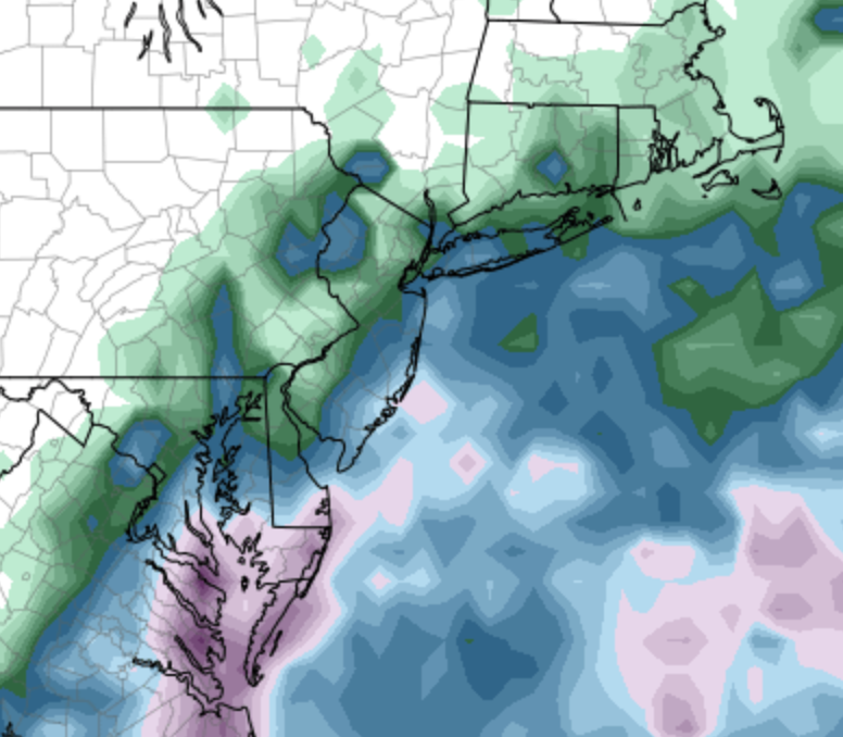
-
Highly recommend the movie Listers on YouTube. It’s about birdwatching, but it’s hilarious.
-
I suppose it wouldn’t be impossible for this to be designated a TD or even a TS. Bastardi is mad that the NHC hasn’t highlighted this yet.
-
After the sprinkle fest coming up, it looks like another beautiful stretch on tap.
-
September 2025 OBS-Discussion centered NYC subforum
Big Jims Videos replied to wdrag's topic in New York City Metro
Ocean temp is still in the low 70s at the beaches. Had quite a few rescues yesterday in this area


