All Activity
- Past hour
-
Hopefully things shift by mid May.
-
Pattern blows. Getting 70 in may is meh. Constant troughing with shit settling in later this week.
-
The relative weeklies centered on last week were released this morning. They as expected based on following the dailies show a slowdown in the rate of warming in 3.4 and 3 (from 0.4 the prior week to 0.1 last week). Also, note that Nino 4 cooled 0.1. Nino 1+2, which is more volatile since it covers a much smaller area, cooled 0.3. I expect that this cooling there is just a blip that will reverse soon: Date………………...1+2………3………3.4……..4 08APR2026 1.1 -0.2 -0.3 0.2 15APR2026 1.2 0.2 0.1 0.6 22APR2026 0.9 0.3 0.2 0.5
-
Not a great or warm AN pattern by any means but as long as sun comes out it’s warm inland
-
yep acatt way overblown with those death sentence calls and charts last week
-
There’s also a solid signal for a few warmer days next week . Couple days of 70 again ahead of the next front . There’s always doom and gloom posts but then you get a bunch of decent to very good days mixed in
-
Tomorrow as well
-
^Thanks. It’s no doubt an extremely warm OHC for so early thanks largely to the very rapid rate of warming earlier this month. That’s why I posted the comparison. However, I feel it’s also important that we keep in mind that this, like ONI, is a measure that is not “relative” to up to date ocean warming. So, in that regard, it’s a bit overdone to the warm side just like ONI is a bit overdone to the warm side in relation to RONI. @bluewave @snowman19
-
Warmest day in weeks today?
-
70 for most. Easy.
-
It’ll be 67-70 here
-
4 days to go Equal to the number of goals the Bruins allowed in the first period in game 4
-
You may have gotten more up your way. When I looked at radar NE of me looked to have a bit heavier and wider swath of rain than down here.
-
what an environment that will be in place across eastern Missouri today. CAMs have been incredibly nasty around the STL market. Going to be wild there today
-

Potential Sever Weather Outbreak 4/27/2026
TheNiño replied to pen_artist's topic in Lakes/Ohio Valley
Moderate now for parts of Missouri and Illinois. I feel somewhat vindicated. -
34 this morning, 1.27" of rain this weekend.
- 916 replies
-
- 1
-

-
- april showers bring may..
- rain
- (and 2 more)
-
30th - the 4th or so still looks like -NAO frumunda' cheese though. Ooph.
-

2026-2027 El Nino
PhiEaglesfan712 replied to Stormchaserchuck1's topic in Weather Forecasting and Discussion
15-16 actually peaked at 1.97 in August: 2015 8 0.99 1.43 1.97 2015 9 1.04 1.48 1.80 2015 10 1.04 1.51 1.91 -
What a great run of wx in the face of "weeks of crap". Winner day after day
-

Potential Sever Weather Outbreak 4/27/2026
pen_artist replied to pen_artist's topic in Lakes/Ohio Valley
I feel like if there is really any chance at svr in NIL it would be late evening. 10 and 11z (haven't look back more) hint at at least thunderstoms with some rotation moving through the 9 PM -12 AM timeframe. -
55 vs 60. Big deal. I mean overall pattern.
- Today
-
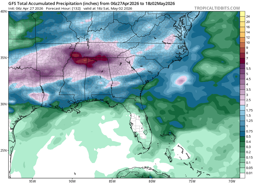
Latest GFS showing lots of precip the ATL area the next week. One can dream. I'd be happy with a quarter of what it's showing at this point.
-
Chilly this morning. Overnight low of 36.
- 916 replies
-
- 1
-
-
- april showers bring may..
- rain
- (and 2 more)
-
Unfortunately, the prospects for any sustained temperatures above the seasonal average is quite low as we move into the month of May and we may even have to wait fairly deep into May to flip the script. Unseasonably strong late season blocking continues to be a dominant mode within the Arctic domain and Greenland resulting in troughniess and below average heights dominating from the northern Inter-mountain West region across the northern Plains, upper-Midwest, and Northeast. There are some hints on the GFS/Euro we could see this pattern breakdown a bit moving towards mid-May, however, it is very possible that is a bit too optimistic and it is just the weighting of climo towards the end of the run making it appear the pattern will breakdown. Hopefully towards the back end of the month we can introduce some heat, humidity, and severe weather chances. While May is the beginning of severe weather season, that doesn't mean we get flooded with threats right away. Just like how June 1 is the official beginning to the Atlantic hurricane season...we aren't flooded with hurricanes on June 2. Patience, patience, patience.
-

2026-2027 El Nino
snowman19 replied to Stormchaserchuck1's topic in Weather Forecasting and Discussion
Yea, the only year with an OHC this warm, this early is 1997. And we have yet another WWB waiting in the wings for May courtesy of the MJO propagation back to the PAC and a protected parade of TC’s….


.thumb.gif.f92b16c631a1d15d405ed77b33f0710d.gif)


