All Activity
- Past hour
-

26th-27th event, coming at us like a wounded duck.
weatherwiz replied to Go Kart Mozart's topic in New England
well I think its still an encouraging sign for places basically along a line say from Danbury to Bridgeport to Southbury-Oxford-Seymour. But the challenge with this is this will be a nowcast situation because ultimately its how the storm evolves which will dictate where the heaviest banding occurs. I am not as nervous about the dry air anymore...the dry air will work in behind the slug of precipitation and will probably help to enhance rates within the precipitation shield. What I would be most nervous about is where the strongest push of WAA occurrs. Given how far SW models have that it may be difficult to even get more than 2-3" back outside of southwestern Fairfield County. We're going to have to rely on mesos for this one I think and just hope the models can pick up on it -
(002).thumb.png.6e3d9d46bca5fe41aab7a74871dd8af8.png)
Boxing Night Snow/Sleet/Ice Dec 26-27 Storm Thread/Obs.
ChescoWx replied to Mikeymac5306's topic in Philadelphia Region
no that is 0.2" of IP not included in the 7.3" of forecast model snow. Does that help? -
.thumb.png.124cc46029a4a9c9d90164e7bc8e3d00.png)
-
NYC Emergency Management Office just sent this out: New York City Emergency Plan Information:Plan: Winter Weather Emergency PlanStatus Change: ActivatedEffective As Of: 12-26-2025 08:00Conditions: Snow accumulation of 3 to 5 inches
-

White Christmas Miracle? December 23-24th
TauntonBlizzard2013 replied to Baroclinic Zone's topic in New England
Snowing in Brockton near 24. Checked ring, suns poking out at home. Ma nature just taunting me at this point -
I even included SLK for @WxWatcher007 ...Vermont... ...Addison County... Starksboro 4.4 ENE 5.5 in 0900 AM 12/24 COCORAHS Bristol 3.1 in 0700 AM 12/24 COOP Middlebury 0.3 N 3.0 in 0700 AM 12/24 COCORAHS New Haven 2.4 SE 3.0 in 0800 AM 12/24 COCORAHS Vergennes 2.8 in 0428 AM 12/24 COOP Shoreham 3.5 NNE 2.5 in 0800 AM 12/24 COCORAHS ...Bennington County... 5 NNW Londonderry 7.7 in 0713 AM 12/24 Peru 1.3 E 4.0 in 0700 AM 12/24 COCORAHS Bondville 2.4 WNW 3.0 in 0738 AM 12/24 COCORAHS Manchester 1.8 SSW 2.7 in 0730 AM 12/24 COCORAHS Manchester Center 0.9 NE 2.5 in 0830 AM 12/24 COCORAHS Manchester 2.8 ENE 2.2 in 0700 AM 12/24 COCORAHS Manchester Center 2.3 NE 1.5 in 0700 AM 12/24 COCORAHS Bennington 1.2 in 1100 PM 12/23 Trained Spotter North Bennington 0.8 in 0900 AM 12/24 COCORAHS North Rupert 1.7 WNW 0.5 in 0700 AM 12/24 COCORAHS Bennington 0.6 SE 0.4 in 0730 AM 12/24 COCORAHS Bennington 0.7 SE 0.1 in 0800 AM 12/24 COCORAHS ...Caledonia County... Wheelock 1.6 S 5.9 in 0700 AM 12/24 COCORAHS East Hardwick 0.4 SE 5.8 in 0900 AM 12/24 COCORAHS Lyndonville 1.1 W 5.3 in 0830 AM 12/24 COCORAHS Sutton 5.0 in 0850 AM 12/24 COOP 1 NW Lyndonville 5.0 in 0854 AM 12/24 Public Wells River 2.1 WNW 4.8 in 0656 AM 12/24 COCORAHS Barnet 3.5 W 4.0 in 0730 AM 12/24 COCORAHS ...Chittenden County... Underhill 4.4 NNE 5.8 in 0700 AM 12/24 COCORAHS Huntington 6.5 S 5.5 in 0800 AM 12/24 COCORAHS Huntington 1.1 E 5.1 in 0700 AM 12/24 COCORAHS Williston 0.2 WSW 5.0 in 0700 AM 12/24 COCORAHS Underhill 5.1 NNE 5.0 in 0700 AM 12/24 COCORAHS Underhill 3.6 ESE 5.0 in 0745 AM 12/24 COCORAHS 2 NW Westford 5.0 in 0806 AM 12/24 NWS Employee Colchester 4.9 in 0729 AM 12/24 NWS Employee Nashville 1 E 4.6 in 0645 AM 12/24 COOP 1 SE West Milton 4.5 in 0756 AM 12/24 NWS Employee 1 ENE South Burlington 4.5 in 1000 AM 12/24 Official NWS Obs Hinesburg 0.9 N 4.4 in 0829 AM 12/24 COCORAHS Shelburne 0.5 ENE 4.2 in 0700 AM 12/24 COCORAHS South Burlington 2.6 SSW 4.0 in 0800 AM 12/24 COCORAHS Burlington 3.8 NW 3.6 in 0800 AM 12/24 COCORAHS Huntington 1.6 SW 3.5 in 0700 AM 12/24 COCORAHS ...Essex County... Lunenburg 2.3 NNW 7.5 in 0530 AM 12/24 COCORAHS Island Pond 5.0 in 0810 AM 12/24 COOP ...Franklin County... Enosburg Falls 2.5 N 5.1 in 0730 AM 12/24 COCORAHS 1 ESE Saint Albans 4.7 in 0833 AM 12/24 Public Montgomery 4.1 ESE 4.5 in 0700 AM 12/24 COCORAHS Enosburg Falls 4.4 in 0841 AM 12/24 COOP Swanton 0.5 NNE 4.0 in 0700 AM 12/24 COCORAHS ...Lamoille County... 1 SSE Smugglers Notch 6.8 in 0906 AM 12/24 Public Johnson 2 N 6.0 in 0700 AM 12/24 COOP Morrisville 6.0 in 0836 AM 12/24 Public 2.5 N Smugglers Notch 5.5 in 0730 AM 12/24 COOP Stowe 0.2 SW 5.2 in 0730 AM 12/24 COCORAHS Jeffersonville 1.3 SSW 4.5 in 0700 AM 12/24 COCORAHS ...Orange County... Braintree 2.8 SW 5.0 in 0800 AM 12/24 COCORAHS Williamstown 3.0 WSW 4.7 in 0700 AM 12/24 COCORAHS 2 NE East Brookfield 4.5 in 0917 AM 12/24 Public Bradford 2.2 NNW 3.8 in 0500 AM 12/24 COCORAHS 2 SE Strafford 3.8 in 0700 AM 12/24 COCORAHS 1.5 E Corinth Corners 3.8 in 0700 AM 12/24 COOP West Fairlee 1.8 ENE 3.6 in 0700 AM 12/24 COCORAHS Fairlee 3.0 in 0856 AM 12/24 Public ...Orleans County... Greensboro 3.9 NNE 7.2 in 0730 AM 12/24 COCORAHS Greensboro 2.1 NNW 6.0 in 0700 AM 12/24 COCORAHS Craftsbury 1.6 SSW 6.0 in 0730 AM 12/24 COCORAHS Craftsbury Common 5.8 in 0700 AM 12/24 COCORAHS Westfield 0.8 WNW 5.5 in 0700 AM 12/24 COCORAHS Morgan 6.7 SE 5.5 in 0800 AM 12/24 COCORAHS Derby Line 1.9 W 5.0 in 0700 AM 12/24 COCORAHS Brownington 4.7 ESE 4.8 in 0800 AM 12/24 COCORAHS ...Rutland County... Shrewsbury 0.8 W 3.8 in 0700 AM 12/24 COCORAHS Rutland 1.2 N 2.6 in 0700 AM 12/24 COCORAHS 1 N Rutland 2.6 in 0700 AM 12/24 COOP West Rutland 1.2 N 1.6 in 0615 AM 12/24 COCORAHS Wallingford 2.7 SSW 1.6 in 0700 AM 12/24 COCORAHS West Rutland 0.9 SSE 0.9 in 0800 AM 12/24 COCORAHS ...Washington County... 3 SSW Woodbury 8.0 in 0826 AM 12/24 Trained Spotter Waterbury 3.0 NW 7.3 in 0600 AM 12/24 COCORAHS 3 SSE Moscow 6.5 in 0626 AM 12/24 Trained Spotter 1.6 W Worcester 6.2 in 0700 AM 12/24 COOP Woodbury 3.4 NNW 6.0 in 0700 AM 12/24 COCORAHS Montpelier 1.7 NE 5.0 in 0700 AM 12/24 COCORAHS Warren 2.8 E 5.0 in 0700 AM 12/24 COCORAHS East Montpelier 4.8 in 0730 AM 12/24 COCORAHS 1 SW East Barre 4.4 in 0459 AM 12/24 NWS Employee Plainfield 1 ESE 4.0 in 0700 AM 12/24 COOP ...Windham County... Westminster 5.5 W 5.8 in 0700 AM 12/24 COCORAHS Londonderry 3.5 E 5.3 in 0700 AM 12/24 COCORAHS Jamaica 1.9 WNW 4.0 in 0715 AM 12/24 COCORAHS Wilmington 0.6 WNW 3.0 in 0658 AM 12/24 COCORAHS Westminster 5.5 NW 3.0 in 0700 AM 12/24 COCORAHS Rockingham 1.1 NNE 2.8 in 0700 AM 12/24 COCORAHS East Dover 1.8 N 2.2 in 0630 AM 12/24 COCORAHS Brattleboro 1.3 WSW 2.2 in 0700 AM 12/24 COCORAHS 5.6 W West Brattleboro 2.0 in 0800 AM 12/24 COOP Rawsonville 0.9 NE 2.0 in 0700 AM 12/24 COCORAHS Marlboro 2.0 NNE 2.0 in 0800 AM 12/24 COCORAHS Putney 0.7 NE 1.8 in 0800 AM 12/24 COCORAHS Brattleboro 0.7 S 1.6 in 0645 AM 12/24 COCORAHS Guilford 7.0 SW 1.5 in 0730 AM 12/24 COCORAHS East Dummerston 0.5 NE 1.5 in 0800 AM 12/24 COCORAHS ...Windsor County... 4 NE West Hartford 5.3 in 0700 AM 12/24 Public 1 NNE Pomfret 5.2 in 0900 AM 12/24 Public Ludlow 3.4 S 4.5 in 0700 AM 12/24 COCORAHS Andover 2.5 NW 4.5 in 0700 AM 12/24 COCORAHS 3 S Ludlow 4.5 in 0850 AM 12/24 Cocorahs Rochester 1.7 NNE 4.0 in 0515 AM 12/24 COCORAHS 1 ESE Weston 4.0 in 0700 AM 12/24 COCORAHS 0.6 E Woodstock 4.0 in 0800 AM 12/24 COOP Proctorsville 0.3 NNE 3.6 in 0700 AM 12/24 COCORAHS Chester 3.0 WSW 3.3 in 0700 AM 12/24 COCORAHS ...New York... ...Franklin County... Saranac Lake 6.2 N 5.8 in 0707 AM 12/24 COCORAHS 0.9 W Malone 5.0 in 0700 AM 12/24 COOP
-
do we have consensus here? it seems like a 4-8 inch snow is on the table if we get these good ratios we could be looking at 6-10 for the city
-

December 2025 Short/Medium Range Forecast Thread
Icy Hot replied to John1122's topic in Tennessee Valley
Highs or lows? -

White Christmas Miracle? December 23-24th
Baroclinic Zone replied to Baroclinic Zone's topic in New England
See if I can manage to get clipped this far west. -

White Christmas Miracle? December 23-24th
mahk_webstah replied to Baroclinic Zone's topic in New England
You’re being tested, my son. And unlike Moses, you will make it to the promised land. -

26th-27th event, coming at us like a wounded duck.
Kitz Craver replied to Go Kart Mozart's topic in New England
Slightly more east, lol… I confused Sikorsky for Bradley -

December 2025 Short/Medium Range Forecast Thread
Carvers Gap replied to John1122's topic in Tennessee Valley
The 12z GEM would shatter some records. Crazy run. A few places would have all time records at risk. -
Thinking 3-6” is a good bet for most of the NYC metro. Really surprised with the model agreement event with the general placement on the heaviest axis
-

White Christmas Miracle? December 23-24th
CoastalWx replied to Baroclinic Zone's topic in New England
Given the last several seasons, so is Satan. -
26th-27th event, coming at us like a wounded duck.
weatherwiz replied to Go Kart Mozart's topic in New England
Encouraging to see, but meanwhile Waterbury was not so great...probably 1-2". But this just goes to show that there will be an extreme cutoff with this. A quick look of the euro looks solid for SW CT too. It's basically going to be what the northeast extent of accumulating snow is -
White Christmas Miracle? December 23-24th
mahk_webstah replied to Baroclinic Zone's topic in New England
God is real -
White Christmas Miracle? December 23-24th
CoastalWx replied to Baroclinic Zone's topic in New England
Coating. Nice to have on Christmas Eve anyways. -
26th-27th event, coming at us like a wounded duck.
mahk_webstah replied to Go Kart Mozart's topic in New England
I don’t know if the tendency in the miles is to make the blocking stronger right now, but I feel like these things always end up further north and east when there’s this kind of battle with confluence. I don’t mean all the way up here, but I think more of southern New England should get a decent snow. and may be up into western mass. -

December 2025 Short/Medium Range Forecast Thread
John1122 replied to John1122's topic in Tennessee Valley
Here's an article about the snow leading up to the ice storm. The epic Winter of '82 stunned the Deep South and East Coast Thursday with a new round of snow and icestorms -- the latest chapter in a continuing siege of severe weather blamed for more than 200 deaths. Blizzards again threatened the Midwest. Dazed southerners suffered through their second storm in 72 hours - a 6-inch deep blanket of snow and ice. New Yorkers barely had time to dry off their snow shovels before turning around to face the remnants of a second storm that began its attack on the city late Thursday. New snows from 3 to 6 inches were forecast on top of 4 to 7 inches of snow that hit late Wednesday before moving up the coast. At least 216 deaths have been blamed on the weather that set 20th Century records for low temperatures. The back-to-back winter storms claimed at least 60 lives in the South alone. In New York two teenage youths fell through the ice-covered surface of Brooklyn's Prospect Park and drowned Thursday when they became trapped under a large chunk of ice. Two other youths also fell through the ice but were rescued. Seven police officers were injured in the rescue attempt. A St. Louis police officer examining a parked car covered with snow and ice opened the door to check for a vehicle identification number and found a body frozen behind the steering wheel. And an employee of New York's Sanitation Department suffered a broken leg when he was run over by his plow after his vehicle struck an object in the road and threw him from the cab. The cruel storms have taken their toll of crops and poultry items, leaving consumers with expected price increases for citrus fruits, vegetables, eggs and chickens. Snow fell in north Florida Thursday, but southern portions of the state were deluged by tropical thunderstorms and winds whipping up to 60 mph. A tornado cut a path a mile long and 100 yards wide in Fort Myers causing an estimated $300,000 in damages to homes. No serious injuries were reported. Furious storms wreaked havoc on Massachusetts, dumping up to a foot of snow in some areas. Boston had almost a foot of snow and strong northerly winds were whipping the accumulations into near-blizzard conditions. All along the east coast, especially southeastern New England, the second half of the storm was expected to hit during the night with forecasters calling for up to another foot of snow, gale-force winds and freezing temperatures. 'This one looks like a big storm with gale winds and considerable blowing and drifting snow expected,' a weather service spokesman said. Connecticut received 6 to 8 inches of new snow, Rhode Island got 8 inches in northern portions of the state and about 6 inches in southern areas. Higher prices for eggs and poultry loom on the horizon for consumers as a result of the bitter cold weather that froze much of the South. 'We're in some pretty tough times as far as poultry growing is concerned,' said Lionel Barton, a poultry expert with the University of Arkansas Cooperative Extension Service. Many baby chicks died in the cold weather and the hens that lived are laying fewer eggs. Florida citrus growers estimated their losses at $500 billion. But in New York Richard Norton, a regional fruit specialist with the Monroe County Cooperative Extension, said a gradual cooling around the Finger Lakes and western New York area last fall helped prepare fruit trees and grapes for this week's subzero readings. Six inches of snow fell on parts of southern Maryland and state police reported 4 inches of snowfall on the lower Eastern Shore. Up to 6 inches of snow fell over Georgia, Alabama, Mississippi, Tennessee, and the Carolinas, making already slippery highways treacherous. An estimated 1 million people were left without power because of ice buildups on utility lines and trees -- 750,000 of those were in Alabama. The weather did little to keep thieves in tow. Atlanta police said 19 people forced to walk home or seek shelter Tuesday night were robbed and dozens of motorists who abandoned their cars after the first snowstorm returned to find their batteries, radios and other valuables had been looted. One Atlanta woman barely made it to the hospital in time to deliver her baby. 'I was worried,' said Gretchen Rehlin, mother of a new daughter. She was forced to walk the last half mile to the hospital because of stalled traffic. 'But my husband was more worried because he was the one who would have had to deal with it (the delivery).' -
December 2025 Short/Medium Range Forecast Thread
Carvers Gap replied to John1122's topic in Tennessee Valley
The 12z CMC and GFS in a bit of a model battle for Jan 1. The 12z has snow and below zero temps. My money is on the Canadian. -
WSWs should be going up for all of Upton's CWA this evening. Maybe the exception being E Suffolk
-
Euro slightly colder
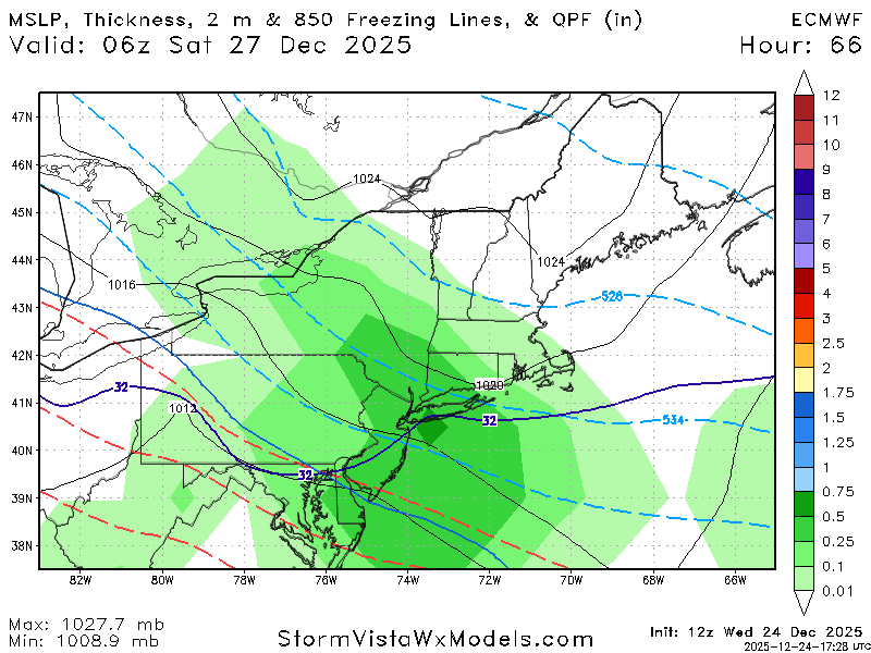
-
26th-27th event, coming at us like a wounded duck.
Kitz Craver replied to Go Kart Mozart's topic in New England
That’s pretty far east as well based on your prior analysis -
White Christmas Miracle? December 23-24th
mahk_webstah replied to Baroclinic Zone's topic in New England
The only important question right now is whether Scott is getting some accumulating snow or not -

White Christmas Miracle? December 23-24th
WxWatcher007 replied to Baroclinic Zone's topic in New England
5.5” total and that’s probably a slight undercount. Great event here. About 10.5” depth.

.png.7849d9242029a8e89dcca093126b44d0.png)


