All Activity
- Past hour
-
The entire I-95 corridor from DC to Boston has been in the same boat. This has been the lowest 7 year combined snowfall total for this area in recorded history. It’s a function of warmer winters and warmer storm tracks. Past instances with low 7 year snowfall totals like which ended in 1992 were more a function of drier winters and not the record warmth of the last decade. The following years with historic snowfall from 92-93 to 95-96 were during a much colder era which no longer exists. So it’s unlikely without a major volcanic eruption that we see such a strong rebound in snowfall during the reminder of the 2020s. I would be happy just to see even a smaller rebound off these record 7 year lows in at least one of the remaining 2020s winters.
-

Spooky Season (October Disco Thread)
Great Snow 1717 replied to Prismshine Productions's topic in New England
Right up to the beginning of winter on 11/1???????? -
.thumb.png.4150b06c63a21f61052e47a612bf1818.png)
Spooky Season (October Disco Thread)
HIPPYVALLEY replied to Prismshine Productions's topic in New England
Maybe up to .25” for some? Certainly nowhere near enough rain to dent the drought up north. -
This winter is looking more and more like a worst case scenario for mid atlantic up to nyc (not sure about sne that feels borderline right now). Could be another 2022-2023 for these regions.
-
Wow I forgot how march was a full on spring month this year. March has totally ceased to be wintery in recent years, the last march with more than an half an inch of measurable snow in central park was 2019. I actually think this alone is more impressive than the overall warming/ lack of snow trend. March totally is not a winter month at all anymore.
-
We'll see if that comes up to us at all or gets pushed OTS as it moves N.
-

Central PA Fall Discussions and Obs
Jns2183 replied to ChescoWx's topic in Upstate New York/Pennsylvania
Hopefully these next few days are the last 80's of the year Sent from my SM-G970U1 using Tapatalk -
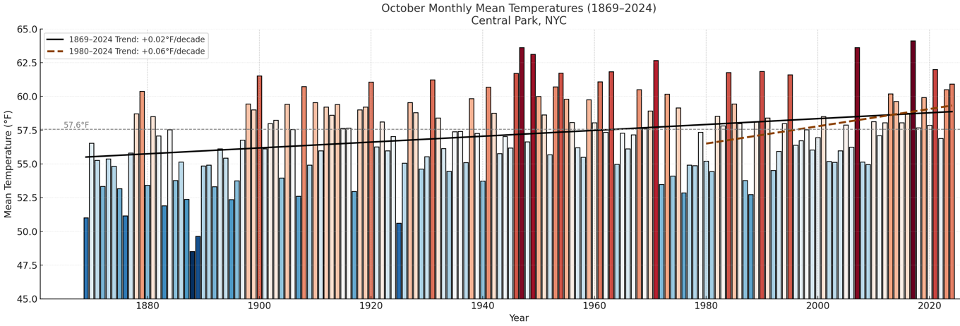
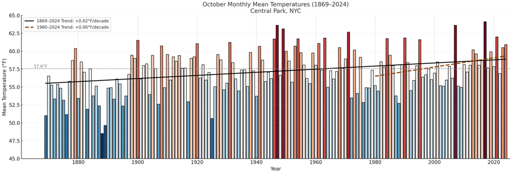
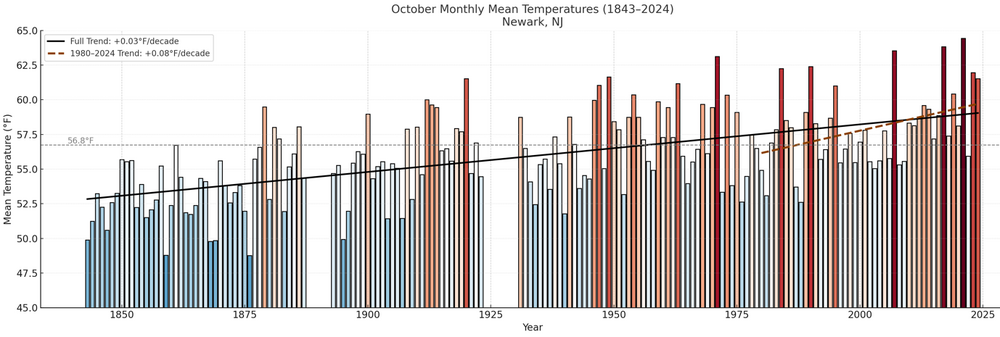
Here's how October has fared in New York City and Newark. The rate of warming has been very gradual, though there has been some acceleration since 1980. The chart's anomalies are based on the 20th century mean temperature for October. For Central Park, the 1991-2020 baseline temperature is 57.9° vs. the 20th century figure of 57.6°. Note: Octobers with large amounts of missing data were excluded.
-
another cutoff under thrb ridge
-

2025-2026 ENSO
donsutherland1 replied to 40/70 Benchmark's topic in Weather Forecasting and Discussion
There were 3 prior cases: 1881-1882, 1889-1890, 1931-1932. 2023-2024 (34.8° was a near miss). Suburbs are cooler. In the larger picture, I don't think Detroit and its vicinity have any worries that winter will essentially become unrecognizable for decades to come. -
Already in the mid to upper 70s here
-
1941 records seem intact today by a good 5 - 7 degrees.
-
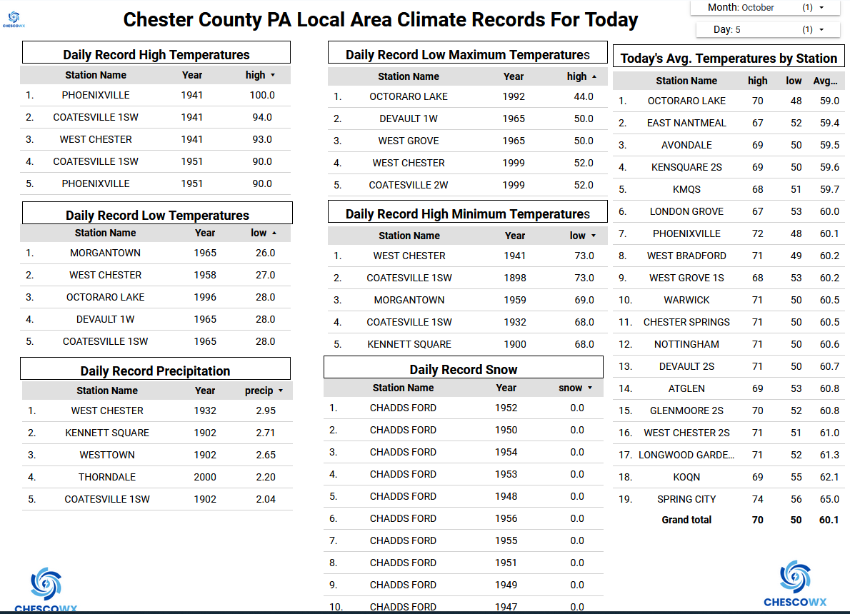
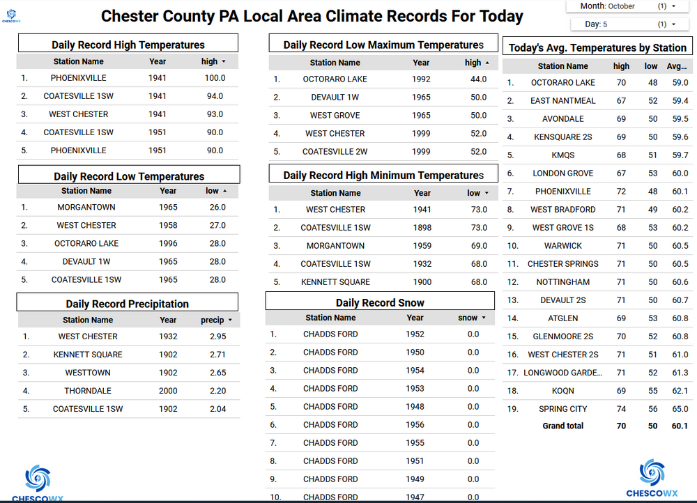
Records: Highs: EWR: 93 (1941) NYC: 94 (1941) LGA: 93 (1941) JFK: 84 (1967) Lows: EWR: 34 (1965) NYC: 35 (1881) LGA: 38 (1965) JFK: 36 (1965) Historical: 1638 - The journal of John Winthrop recorded that a mighty tempest struck eastern New England. This second severe hurricane in three years blew down many trees in mile long tracks. (David Ludlum) 1786 - The famous "Pumpkin Flood" occurred on the Delaware and Susquehanna Rivers. Harrisburg PA reported a river stage of twenty-two feet. The heavy rains culminated a wet season. (David Ludlum) 1786: The famous “Pumpkin Flood” occurred on the Delaware and Susquehanna Rivers. Harrisburg, PA, reported a river stage of twenty-two feet. 1844: A hurricane swept along the path from Cuba to the Florida Straits to the Bahamas to Bermuda and finally to Newfoundland. Such destruction "is rarely known in the annals of commerce." (Ref. Wilson Wx. History) 1892: Washington, DC recorded a trace of snow, its earliest trace of snowfall on record. (Ref. AccWeather Weather History) 1917 - The temperature at Sentinel, AZ, soared to 116 degrees to establish an October record for the nation. (The Weather Channel) 1941: Record maximum temperature for October 96° in Washington, DC. (The Washington Weather Records - KDCA) Bermuda high pressure pumped record heat across much of the east. Phoenixville, PA reached 100°, establishing an October state maximum temperature record. Locations recording their all-time October high temperature records included: Baltimore, MD: 97°, Washington, DC: 96°, and Philadelphia, PA: 96°. Other locations reporting daily record high included: Roanoke, VA: 98°, Harrisburg, PA: 97°, Richmond, VA: 97°, Lynchburg, VA: 96°, Raleigh, NC: 96°, Reading, PA: 94°, Trenton, NJ: 94°, Elizabeth City, NC: 94°, Wilmington, DE: 94°, Greensboro, NC: 94°, Newark, NJ: 93°, Norfolk, VA: 93°, Allentown, PA: 92°, Greenville-Spartanburg, SC: 92°, Chattanooga, TN: 92°, Williamsport, PA: 91°, Atlanta, GA: 91°, Huntington, WV: 90°, Asheville, NC: 90°, Avoca, PA: 89°, Scranton-Wilkes Barre, PA: 89°, Lexington, KY: 89°, Beckley, WV: 88° and Elkins, WV: 86°. (Ref. Wilson Wx. History) 1954: Infamous Hurricane Hazel, which caused tremendous destruction in the Carolinas, was born on this date. (Ref. AccWeather Weather History) 1966: Inez formed unusually far east for late in the season, Inez is among the deadliest hurricanes on record, with an approximate death toll of over 1,000 people across several Caribbean countries. In addition to being exceptionally deadly and intense, Inez was the first solitary storm on record to affect the West Indies, Bahamas, Florida, and Mexico all on one track. 45 sailors died in shipwrecks in the Straits of Florida along with 3 on land. Intensification resumed after passing Guadeloupe, and Inez rapidly reached its peak of 150 mph while south of Puerto Rico on September 28. Inez crossed the Florida Keys on October 5 as a strengthening hurricane, delivering hurricane-force winds to all of the Keys. Inez then reaching its peak in the Gulf of Mexico with 140 mph winds and 948 mb on October 9. The threat to Texas increased, but Inez was forced southwest late on October 9 and the storm weakened before making landfall near Tampico, Mexico, on October 10. Total damage more than $150 million and on its very long track as a powerful major hurricane, passing through the Lesser Antilles, Haiti, Florida, and especially Mexico. Inez's Storm Track - Weather Underground 1970: An F4 tornado moved northeast from northern Pottawatomie County, into southeast Lincoln County in Oklahoma. A total of 564 homes, 157 businesses, 12 public buildings, 5 schools, and 10 churches were either damaged or destroyed. In Prague, there were 4 deaths and 80 injuries, as the tornado tracked through the middle of town. (Ref. Wilson Wx. History) 1972 - Heavy rains, mostly the remnants of Tropical Storm Joanne, fell across much of Arizona. It was believed to be the first time in Arizona weather history that a tropical storm entered the state with its circulation still intact. The center was over Flagstaff early on the 7th. (3rd-7th) (The Weather Channel) 1987 - It was another day of scorching heat for the southwestern U.S. Afternoon highs of 102 degrees in Downtown San Francisco, and 104 degrees at Monterrey, established all-time records. The high of 101 degrees at San Jose was a record for October. Sacramento tied their record for October for the third time in the month, with a reading of 102 degrees. The high for the nation was 111 degrees at San Luis Obispo and Palm Springs. Twenty cities in the southeastern U.S. reported record low temperatures for the date, including Knoxville TN with a reading of 34 degrees. (The National Weather Summary) 1988 - Thirteen cities in the central U.S. reported record low temperatures for the date, including Duluth MN with a reading of 21 degrees. Goodland KS reported an afternoon high of 39 degrees. Showers over Upper Michigan produced an inch of snow at Marquette. (The National Weather Summary) 1995: After accelerating northward out of the Gulf of Mexico, Opal moved quickly through the Eastern United States. Despite hundreds of miles of travel from the Gulf of Mexico, gale force winds blew through western Virginia. Winds sustained at 40 mph, with gusts past 60 mph, blew down trees mainly above 2000 feet elevation in the Shenandoah Valley and along the Allegheny Plateau. Dozens of trees were blown down along Skyline Drive in Page and Warren counties. In Waynesboro, a canopy over a service station was ripped off. South Winchester and Elkton saw 2600 homes and businesses without power as lines were downed by the winds. Two tornadoes struck the tidewater. One touched down at West Point airport in New Kent county. It tore the roof off a hangar, destroying a small airplane and damaging four others. (Ref. Hurricane Opal) 1998: A big three-day snowstorm came to an end over the Black Hills in South Dakota. Galena was buried under 48 inches of snow and Lead checked in with 42.1 inches. Rain and embedded thunderstorms dumped a large area of 4 to 10 inches of rain producing widespread flooding. Most of the flooding was confined to low areas along creeks and highways. The hardest hit areas were in southeast Kansas and west central and central Missouri. Numerous highways were closed due to high water. (Ref. Wilson Wx. History) 2005: North Dakota: After sweating through 90 °F plus heat at month's onset, North Dakotans see heavy snow fall across much of the state. Observers report 12 inches of snow around Halliday and 10 inches at Fairfield, north of Belfield in Billings County. Minot measures 8-10 inches. (Ref. WxDoctor) 2010: Sviolent hail storm taken on Tuesday, Oct. 5th around 59th Ave. & Cactus in Phoenix Severe thunderstorms produced the largest hail ever measured in Phoenix, Arizona, and Maricopa County. Hailstones up to 3 inches in diameter caused extensive damage. The largest known hailstone to fall in in the state of Arizona (back to 1950) was 4.5 inches in diameter. This record hail fell in Mayer on September 20, 1995. (Ref. Weather Guide Calendar with Phenomenal Weather Events 2012 Accord Pub. 2011, USA) 2010: Large hail pounded Phoenix, Arizona, causing nearly $3 billion in damage. Click HERE for more information from the NWS Office in Phoenix, Arizona.
-
(002).thumb.png.6e3d9d46bca5fe41aab7a74871dd8af8.png)
Central PA Fall Discussions and Obs
ChescoWx replied to ChescoWx's topic in Upstate New York/Pennsylvania
Happy Red Phillies October to those who celebrate! Tough one last night! Today looks to be our warmest day over the next week. Lower spots in the area should approach 80 degrees. We should see temperatures a couple of degrees cooler by tomorrow and then falling to below normal levels by Thursday. Highs on Thursday should be not too far from 60 degrees. There is a chance of some beneficial rain on Tuesday night into Wednesday morning. That looks to be our only chance of rain over the next week. Go Phillies!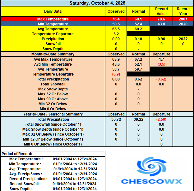
-
E PA/NJ/DE Autumn 2025 Obs/Discussion
ChescoWx replied to PhiEaglesfan712's topic in Philadelphia Region
Happy Red Phillies October to those who celebrate! Tough one last night! Today looks to be our warmest day over the next week. Lower spots in the area should approach 80 degrees. We should see temperatures a couple of degrees cooler by tomorrow and then falling to below normal levels by Thursday. Highs on Thursday should be not too far from 60 degrees. There is a chance of some beneficial rain on Tuesday night into Wednesday morning. That looks to be our only chance of rain over the next week. Go Phillies!
-
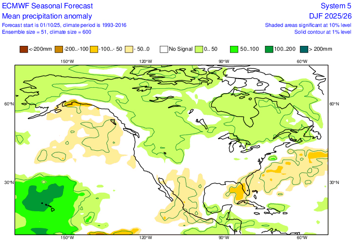
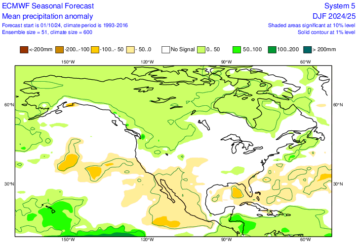
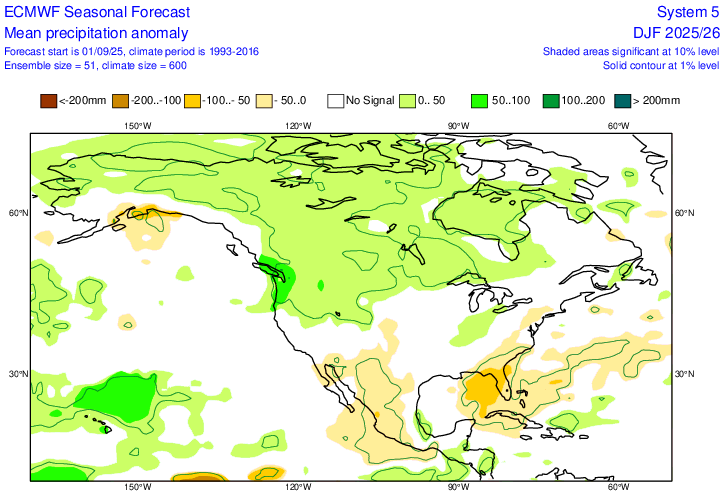
New (Oct) Euro precip anomaly forecast for DJF: very slightly wetter in NE/SE and very slightly drier part of Midwest vs Sept outlook and similar to Oct ‘24 outlook for last winter/La Ninaish NN much of E US but BN signal deep SE with lack of dominant ST jet Sept ‘25 outlook for DJF: Last Oct precip for last winter:
-

Spooky Season (October Disco Thread)
Damage In Tolland replied to Prismshine Productions's topic in New England
Couple showers Tuesday night? -

Spooky Season (October Disco Thread)
Modfan2 replied to Prismshine Productions's topic in New England
Hopefully a good time for the grass seed to take hold that I am putting down -
From 48 to 70 / 57. Warm 60 hours with 3 more days of low - mid 80s, warmest spots again to the 86-87 range. Front later PM Tue brings some rains. Cooler Wed - Fri. Models now with low cutting off under the ridge see,s similar to a few weeks ago more into the southeast by 10/12 - 10/15 peiord. Looks like ridging comes builds back east beyond there - overallwarmer.
-

2025-2026 ENSO
michsnowfreak replied to 40/70 Benchmark's topic in Weather Forecasting and Discussion
How did a colder climate make it possible? Remember places further north are different than NYC. For those in colder climes its more about patterns. You can easily see less snow in a colder winter or more snow in a milder winter. -
Being honest, I'm feeling underwhelmed with my prelim thoughts. So far everything has the feel of a slow start, couple brief but potentially exciting periods Jan/Feb, and lots of boring stuff in between. The flavors of 05-06 and 08-09 come to mind but I'm just guessing. One thing that's nearly certain is some sort of "unexpected persistence" will happen with little lead time or analysis. That kind or stuff is what keeps me out of making any kind of definitive calls from way out in time. No matter how much early season analysis is done, a piece of winter personality bucks consensus/traditional thinking. What that will be this year (if at all) is anyone's guess. My optimistic side says the AO/NAO will play nice more often than being hostile. Especially the NAO. A legit blocky winter can offset a lot of nina crappiness. I sure don't like look of Pac SSTAs so far but that's just one piece of the puzzle
-
2025-2026 ENSO
michsnowfreak replied to 40/70 Benchmark's topic in Weather Forecasting and Discussion
LOL I was going to post the exact same thing. Must be from Arkansas. Guess we somehow dont get snow in Michigan while they're buried in Arkansas -
2025-2026 ENSO
michsnowfreak replied to 40/70 Benchmark's topic in Weather Forecasting and Discussion
I dont think we'll ever average a DJF temp of 35°, certainly not in the lifetime of anyone currently living. Will probably hit it at a few times, but never average it. -
Low of 56. 85 maybe today
-
Central PA Fall Discussions and Obs
Jns2183 replied to ChescoWx's topic in Upstate New York/Pennsylvania
Maybe you can join the disaster that will be the coaching carousel this year as well Sent from my SM-X210 using Tapatalk