All Activity
- Past hour
-
WTF?
- Today
-
0z GEFS has some interesting members now
-
 63, crystal clear skies up here in Allamuchy township. Cool breeze. Amazing how getting an hour outside of NYC hiw black the skies are. So many stars.
 -
Being a near east-coaster and also considering last year’s devaststing killer season, especially in NC, I sincerely love your optimism and hope the current pattern holds. One hit already this season is more than enough. Besides it’s fortunately not easy for the EC to be hit compared to the Gulf. Getting two EC TS+ hits in one year isn’t too common…~1/3 of years since 1995. However, regarding EC hits from storms that weren’t home-brew: -2022’s only hit wasn’t til 9/30 (Ian) -2018’s only hit wasn’t til 9/14 (Florence) -2016’s only hit other than TS Bonnie in May wasn't til 10/8 (Matthew) -2012’s only hit other than TS Beryl in May wasn't til 10/29 (Sandy) -2003’s only hit wasn’t til 9/18 (Isabel) -1999’s only H hit wasn’t til 9/15-6 (Floyd) -1989’s only hit wasn’t til 9/21-2 (Hugo) -1985’s worst hit by far wasn't til 9/26-7 (Gloria) -1950’s only hit wasn’t til 10/17 (King) -1947 had a rare 3 EC hits and they were all 9/17+ and only one was home-brew -1945 had one H hit and it wasn’t til 9/15 -1944’s worst H hit wasn’t til 9/14 -1941’s only hit wasn’t til 10/6 -1938’s only hit wasn’t til 9/21 -1928’s worst hit wasn’t til 9/16 -1898’s worst hit by far wasn’t til 10/2 So, these 16 years’ EC hits weren’t til 9/14+ and 50% weren’t til 9/21+.
-
 No sound but very bright. I was waiting for the sound
 -
After that re-drenching ~2” that fell yesterday evening, I’ve had as of 11PM only some on and off largely light rain since early this morning amounting to <0.1” here despite some nearby areas having heavier rains. That gets me to a ridiculous ~16.7” MTD! The mosquitos have been constantly partying this month like it was 1999. We’ll see how the rest of the night goes.
-
Zero chance of tropical rain for Texas this season. Seems about right. Desertification's right on track! Time to pretend I'm on the Giza Plateau with the ardor of an Indiana Jones, looking for 13th Dynasty artifacts.
-

2025-2026 ENSO
donsutherland1 replied to 40/70 Benchmark's topic in Weather Forecasting and Discussion
Yes, most of the Philadelphia’s winter warming has occurred after winter 1984-85. -

2025-2026 ENSO
Stormchaserchuck1 replied to 40/70 Benchmark's topic in Weather Forecasting and Discussion
Sub 5100dm over the Artic circle tomorrow! Areas of cold 500mb >60N continues to be a theme for the warm season since May 2024, and May this year. I say for cold Winter prospects, give me cold upper latitude 500mb earlier in the year. I think it correlates to more -EPO conditions down the road. Hopefully the trend of cold 500mb continues in the Fall. It shut off after September last year, and in the Fall of the last several years. -
We are near the solar maximum, so the exact opposite. I am almost inclined to think this was a brain fart and he meant maximum. I understand the reasons why people spread disinformation, but this is something you can disprove with a quick google search. Usually when people spread bullshit they are a bit smarter about it. I know many of us are extremely anti Bastardi (for good reasons), but even he would never do something like this. The disinformation he spreads takes a bit more than a quick google search to disprove. It’s absolutely still bullshit, but he’s smart enough about it that people buy in and listen to him. I would imagine the guy claiming we are at a solar minimum would have a bunch of tweets correcting him, no?
-
Yeah, I realized you were using 1991-2020 normals. But on that and even on the 2nd chart, it still looks to me like the bulk of the warming at Phil. has been since the late (or maybe mid) 1980s. Imagine cutting the 2nd chart off in 1987. If so, I don’t think any longterm warming trend would show. Instead, it appears to me like the line would be pretty flat. Do you see what I’m seeing?
-
 it sounds like a fireball, I wonder how close to the ground it got? Did you hear any sound with it (a fireball with sound is called a bolide)?
 -
2025-2026 ENSO
donsutherland1 replied to 40/70 Benchmark's topic in Weather Forecasting and Discussion
I used the latest normals. That makes almost everything appear cold. Here’s the same chart using the NOAA’s 20th century mean as the baseline.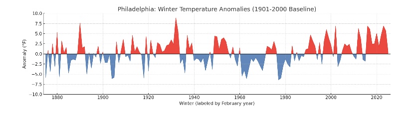
-
Very bright streak. Spooked me for a second.
-
The 1944 hurricane was extremely underrated, it was a Great Hurricane that came after a Historic Summer. Great Atlantic Hurricane (Sept. 1944) There's a good reason why New Jersey State Climatologist David Robinson calls the Great Atlantic Hurricane "the worst hurricane ever to hit New Jersey in the 20th century." The damage unleashed by this storm was devastating along the entire coastline, with hundreds of homes on Long Beach Island washed out to sea and huge piers in Atlantic City split up into pieces. A resident who witnessed the 1944 destruction in Atlantic City told The Star-Ledger decades later: "It picked up the boardwalk like toothpicks and threw it.” (Photos by New Jersey State Police | NJ State Library) Len Melisurgo | NJ Advance Media for NJ.com Great Atlantic Hurricane (Sept. 1944) This hurricane was so powerful that it swept large boats and barges onto land in Atlantic Highlands, grounded a large passenger boat in Keyport, crushed roads and sections of the boardwalk in Long Branch and destroyed the boardwalk and sea wall in Margate. (Photos by New Jersey State Police and U.S. Navy | NJ State Library) More rare photos of the Great Atlantic Hurricane of 1944 Len Melisurgo | NJ Advance Media for NJ.com Great Atlantic Hurricane (Sept. 1944) The 1944 storm was ferocious, blasting the Jersey Shore with winds as strong as 96 mph and waves reported to be as high as 25 to 30 feet. Hundreds of homes were destroyed on Long Beach Island and hundreds more on the Barnegat Peninsula. On LBI, the hurricane’s storm surge pushed vacation cottages off their foundations and deposited them blocks away. In Manasquan, the storm left 6-foot sand dunes along First Avenue, looking like snowdrifts. In Cape May, the grand piano in Convention Hall was reportedly washed out to sea. (YouTube video by wetwatervideo) Len Melisurgo | NJ Advance Media for NJ.com Great Atlantic Hurricane (Sept. 1944) This video recounts the widespread destruction in Atlantic City. One witness says parts of the city were under 5 feet of water and he watched the ocean surge rip apart large sections of the Atlantic City boardwalk. (YouTube video by pcctv1)
-
1903 also had a very strong hurricane that took a path close to the city, what category was this storm? Great Hurricane (Sept. 1903) The Great Hurricane of 1903 made a direct hit on New Jersey, causing heavy flooding and structural damage up and down the Shore and as far inland as Trenton (pictured here in a major flood that followed the storm). Among the damage reported by Shore News Today: “Hurricane-force winds downed telephone and telegraph wires across the coast, ripped the roofs off of 60 cottages and destroyed the railroad bridge to Brigantine. Most Jersey Shore fishing piers were severely damaged or destroyed.” (Photo credit: Trentoniana collection | Trenton Public Library) Len Melisurgo | NJ Advance Media for NJ.com Great Hurricane (Sept. 1903) The Great Hurricane of 1903 made a direct hit on New Jersey, causing substantial damage to houses and barns, many of which had their roofs blown off, according to a report by NorthShoreWX.com. The storm’s ferocious winds reportedly uprooted scores of shade trees and fruit trees across the Garden State. In Sea Bright, some houses were completely destroyed by this hurricane, the New York Daily News reported. Pictured is an old map showing the storm's path. (Photo credit: NOAA)
-
Don, Am I looking at that graph right? Has virtually all of the warming at Phil been since the late 1980s?
-
How bright was it? Like a regular star or brighter like a planet?
-
Wow the 1821 storm makes the much publicized 1938 storm sound like a small gale. Norfolk - Long Island Hurricane (Sept. 1821) This massive storm, known as the Norfolk and Long Island Hurricane of 1821, churned its way up the Atlantic coast from Virginia and slammed into Cape May in southern New Jersey as a fierce Category 3 hurricane before speeding up along the Jersey coast and pounding New York City and Long Island. Damage was reported to be heavy in Cape May, where a 5-foot storm surge flooded the small resort city and sustained winds were believed to be as high as 110 mph. This map, produced by the Swiss Re global reinsurance company, shows the storm's likely path. (Swiss Re) Len Melisurgo | NJ Advance Media for NJ.com Norfolk - Long Island Hurricane (Sept. 1821) This graphic shows the intense winds generated by the Norfolk and Long Island Hurricane of 1821, which flooded Cape May and pounded the Jersey Shore, New York City and Long Island. (Swiss Re)
-
love it
-
are you serious-- at what time? it has to be really bright to see one on a highway in all this light pollution!!
-
They do. I wish I had time to play. We are meeting friends in Bangor tomorrow and decided to make a weekend of it and stay in the coast. This is a nice place. It was low tide so we walked quite a ways out at Popham.
-
Saw a crazy shooting star on the way home on the southern state. Was green.
-
Those really cold summers were 1903 and 1927. Both were very wet summers in a colder climate. Drier years followed and by the time a wetter cycle (internal variability and climate change-forced) returned, the climate had warmed quite a bit from where it was prior to 1930.


