All Activity
- Past hour
-
There is strong telconnector and multi-ensemble convergence on a heavy round of psychosis.
-
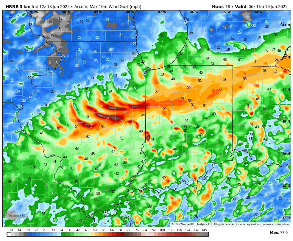
Yeah not sure what is playing into the HRRR but we have decent height falls tomorrow, increasing dynamics, steep lapse rates, and moderate instability. I know the main forcing/cold front is west...but more times than not our convection develops with the pre-frontal trough and not the actual cold front. But I would not be shocked to see the HRRR ramp up as we get closer. Same thing with the mid-western states...HRRR I think underplaying, especially Mississippi Valley
-
this may be the last day i wear my hoodie for a while..
-
Maybe a bit of chocoloate sauce dripped on the nape?
-
Agreed. I've noticed over the last couple of months or so that the meso models have under forecast strong/severe thunderstorm events for Southern New England. Models then start playing catch-up about 12 hours before the event start & continue playing catch-up right up to game time.
-
Yeah... I'm kind of Doctor J vs Mr Hyde when comes to heat. I'm utterly fascinated by the "big heat" synoptics, just like I am for big winter events. I don't like to live in them. SO ...admittedly. That said, it is not like rooting them on, tho. I believe I'm morally okay with it, because as a science curiosity, that's where I'm interesting in them is. I'm not like Kevin, who roots on the dystopian horror of people cooking in the streets from the confines of his well-A.C.ed, model interpretive war-room. They have particular identities. Especially in these recent eras of the ongoing CC/attribution stuff, when they are occurring with greater frequency all over the world, and are dangerous ... ( more deaths than all other weather event types combined), there's definitely value in learning how to use the guidance. etc etc.
-
Storm mode will evolve to be linear quickly and flow aloft is predominately unidirectional, however, enough turning of the llvl winds that there is certainly a risk for an embedded tornado or two, particularly within the Hudson and Connecticut Valley where the backed flow will be enhanced some. Also looks like a bit of a theta-e ridge which will locally enhanced llvl CAPE and decent sfc vorticity. The line arrives coinciding with an increase of the LLJ as well and models want to hang around the steeper lapse rates. If we can get discrete cells ahead of the line (big if) there will be risk for multiple tornadoes.
-
Props to the AIFS, it's been south for days now with this system.
-
Perhaps you are unclear on the concept of "not based upon all present indicators ... "
-
I think the HRRR is underplaying aerial coverage tomorrow
-
The last couple runs of the HRRR have been particularly ridiculous with that: I just want some good rain before the heat arrives this weekend.

-
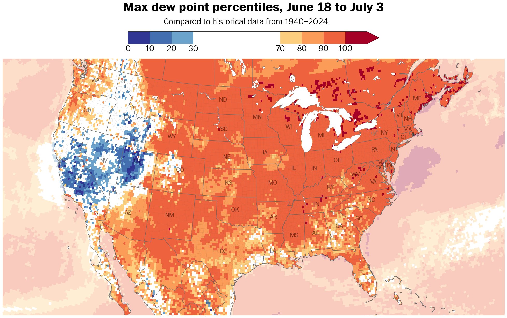
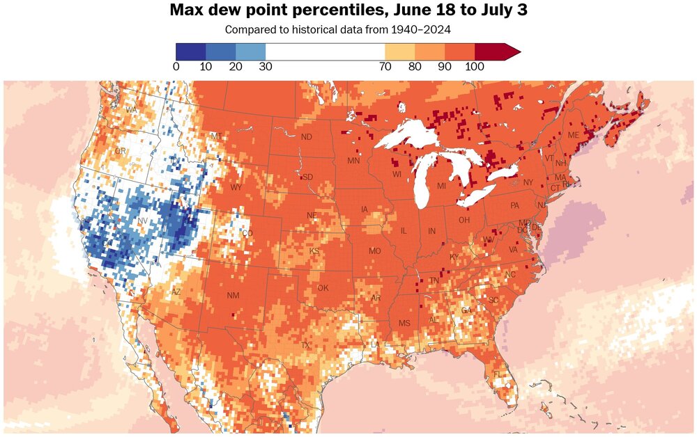
Not only hotter, but more moist and humid as dew points reach the 90 th percentile, or greater, over a vast area of the US.
-
We shall be seeing an enhanced risk tomorrow for at least western MA and western CT
-

2025 Atlantic Hurricane Season
BarryStantonGBP replied to BarryStantonGBP's topic in Tropical Headquarters
to that one guy on storm2k who predicted 13/6/3: every day is a fine day right? -
Central & Eastern Pacific Thread
BarryStantonGBP replied to Windspeed's topic in Tropical Headquarters
I heard someone had a dream last week (when Dalila was active) of logging onto the NHC front page and seeing a Category 4 off the west coast of Mexico, well before models started to initialize Look what we have here now -
Could be some record breaking high minimums.
-
Every piece of guidance has 3-4 days of 90+
-
Lol pencil that in for late September
-
Socked in again this morning with clouds, fog, mist and drizzle. Another .15" rainfall last 24 hours. Has gotten very humid and on the muggy side.
-
WHY do we keep doing this?
-
Yeah, 12z HRRR looks a little better but still messy. Hopefully we avoid too much crapvection before the main line moves through. Optimistically… I can hope whatever pops ahead of the line is rotating and interacting with the leftover boundaries from the storms that just came through here.
-
hrrr selling a 2" drought buster, need to lock in
-
Starting to look like more run of the mill type heat for most especially the city and east. The eastern periphery of the ridge is prone to backdoor fronts and cloud/T-storms. Also looks like winds will try hard to veer onshore which heightens the humidity but would make it hard to reach 95. But if we have dewpoints well into the 70s with temps over 90 it’s still disgusting. Just not historic, more like our more typical FL type heat of late. Inland away from the seabreezes or backdoor intrusions can likely make it to 100.
-
Kind of a contnuation of that buregeoning theme from last cold season of a colder se Canada...lets keep that going into next winter.
-
This is not a correct assessment based upon all present indicators ... it's okay bro. It's only mid June. We'll have other shots at this over the next 6 to 8 weeks ( before the GFS routines begins snowing at D10 in mid August LOL )